- Mudeford
-
Coordinates: 50°43′23″N 1°44′53″W / 50.723°N 1.748°W
Mudeford 
 Mudeford
Mudeford shown within DorsetOS grid reference SZ178914 District Christchurch Shire county Dorset Region South West Country England Sovereign state United Kingdom Post town CHRISTCHURCH Postcode district BH23 Dialling code 01202 or 01425 Police Dorset Fire Dorset Ambulance South Western EU Parliament South West England UK Parliament Christchurch List of places: UK • England • Dorset Mudeford was originally a small fishing village in the borough of Christchurch, Dorset southern England, lying at the entrance to Christchurch Harbour. The River Mude (which starts from Poors Common in Bransgore, Hampshire[1]) and Bure Brook (which starts from Nea Meadows in Highcliffe, Dorset) flow into the harbour there. In recent times the boundaries of Mudeford have expanded and include modern housing. Approximately 4000 people now live in the area giving a population density of roughly 24 persons per hectare.
Mudeford includes two woodland areas (known as Mudeford Woods and Peregrine Woods), a recreation ground on the north side of Stanpit (used to play cricket since the 19th century, probably as far back as the 1860s)[2] and All Saints Church (built in 1869 as a gift by Mortimer Ricardo, who lived at Bure Homage House).[3]
The village is home to both Mudeford Infants School and Mudeford Junior School.
Contents
Mudeford Quay
Mudeford Quay was constructed in the late 1940s. Prior to this, The Haven, as it was then known was surrounded by sloping beaches. The Run then was much wider than it is now and the area was subject to terrible erosion. So much so that Christchurch Council purchased the whole area in 1945. Five years later the area had been raised and reinforced with steel piles and concrete.[4][5]
Today the quay which consists of The Haven Inn public house, a number of ex-fishermans' cottages and a large car park is still used by local fishing boats as well as being a base for many water sports. A RNLI inshore lifeboat station is located on the quay.
In 1809, a troopship carrying 100 soldiers returning from the Peninsular War, sank in Christchurch Bay. The whole complement was saved by fishermen from the village. A specially built lifeboat was stationed at Mudeford from 1802, privately owned and manned by the local fisherman.[6] It was subsumed by the RNLI in 1962 and in June 1963 a new inflatable boat was delivered.[7] Between 1963 and 1995, the Mudeford Lifeboat was launched 766 times and rescued 308 people.[8]
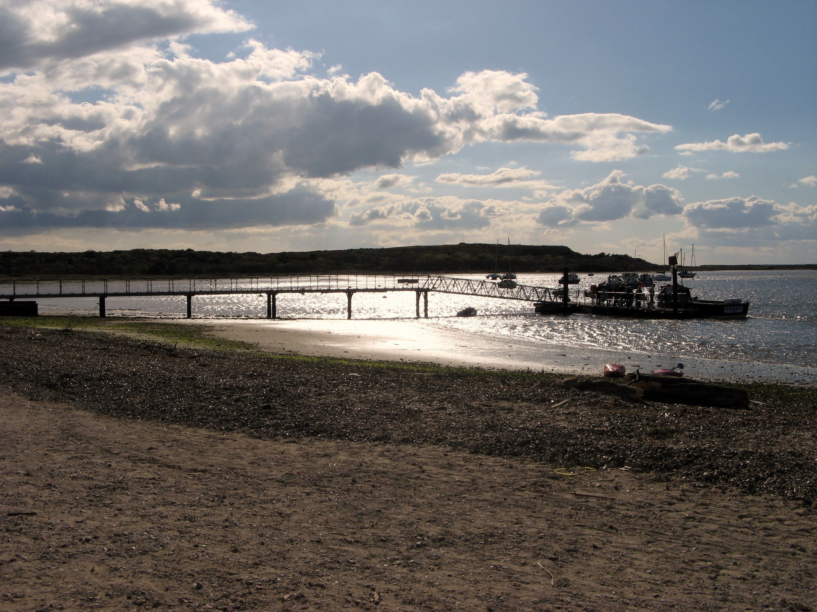
 Mudeford Ferry April 2008
The Mudeford ferry operates between the Quay and Mudeford Sandbank on Hengistbury Head.[9] The ferry was until the 1960s operated by rowing boats with payment being at the discretion of the passenger. Mudeford Quay is at the entrance to the Harbour known as "The Run". The area was historically much involved in smuggling and the site in 1784 of The Battle of Mudeford.[10] George III is recorded as having visited Mudeford in 1801 and using a bathing machine.[11]
Mudeford Spit
Historically part of Christchurch, Mudeford Spit was sold to Bournemouth Borough Council in 1935.[12] It is the larger of the two features, the other being the Haven, that almost encloses Christchurch Harbour, leaving the water within to exit through a narrow channel known as The Run. Formed by sand and shingle brought around Hengistbury Head by longshore drift and pushed towards the shore by waves from the east, the spit is the most mobile of Dorset's geographical features. Prior to the construction of the long groyne at Hengistbury Head in 1938, it tended to grow steadily in a north-easterly direction and on occasion stretched as far Steamer Point and Highcliffe Castle; most notably in 1880.[13] It has been breached a number of times naturally; 1883, 1911, 1924, 1935 and once deliberately in the 17th century when an attempt was made to construct another entrance to the harbour.[14] After the last breaching in 1935, the end of the spit broke off and drifted towards the beach at Friars Cliff where it formed a lagoon.[13] The groyne built in 1938 to protect Hengistbury Head from erosion had an adverse affect on the spit as it prevented movement of material around it. The spit began to erode due to wave action from the east and many attempts have been made since to stabilise the situation. Small seawalls were constructed on the spit in the 1960s and a large number of rubble groynes were put down during the 1980s.[13]
The Beach huts, located on Mudeford Spit, can be reached on foot or land train from the Hengistbury Head side of the harbour, or by the Ferry from Mudeford Quay.[15] Also on the spit is the "Black House", a local landmark. Although it features in a number of local smuggling legends, it was only built in 1848 for the manager of the Hengistbury Head Mining Company, and therefore these tales are unlikely to be true.[16]
Sandhills
Sandhills was the holiday home of Sir George Rose, Member of Parliament and close friend and advisor to the prime minister William Pitt. It was built on the beach at Mudeford and Sir George's other great friend, King George III stayed there on a number of occasions, helping to promote Christchurch as a tourist destination.[17] Sandhills, Mudeford was also home to George Rose's two sons: Sir George Henry Rose, politician and diplomat, and William Rose, poet.[18] Field Marshal Hugh Rose, 1st Baron Strathnairn, GCB, GCSI, son of George Henry Rose also spent time living at the family home.[19] Sandhills is now a holiday park owned by Park Holidays UK with static caravans in the grounds but the house still remains although it has been converted to flats.
Gundimore
Gundimore is a house near Avon Beach built in 1796 for the poet William Rose. Visitors to the house included fellow poets Coleridge and Southey. Sir Walter Scott stayed there whilst writing his epic poem Marmion. Rose designed one of the rooms to resemble an Arab tent, circular with a shallow pitched, conical roof.[20]
Other historic buildings still in existence
- Mudeford House (later Avonmouth Hotel and Christchurch Harbour Hotel)[21]
- Waterford Lodge (later Waterford Lodge Hotel)[22]
- Elmhurst (later The Anchorage)[23]
Bure Homage House
On the outskirts of the original Mudeford village, close to the course of Bure Brook, was an imposing mansion called Bure Homage House with a large associated estate which included Friars Cliff. It was built at the start of the 19th century, replacing Bure Farmhouse, by Charles Stuart, 1st Baron Stuart de Rothesay. In 1837, it was sold to Sophie Dawes, a renowned smuggler who became a French Baroness.[24] During World War II, it was used as an officers mess by the 405th Fighter Group who operated at RAF Christchurch. After the war it was used for a while by the Signals Research and Development Establishment.[25] It was demolished in 1957. It was situated in the area which is now called Bure Homage Gardens, and accessed via the lodge which is still to be seen opposite the Waterford Hotel. It was associated with the nearby Highcliffe Castle which was built later between 1831 and 1835. The land is now occupied by residential housing.[24]
Christchurch Airfield
Main article: Christchurch AirfieldChristchurch Airfield, which had an important role in World War II as RAF Christchurch, covered the fringes of Mudeford, but was mainly in the neighbouring district of Somerford. Since the airfield complex was demolished in 1966, it was largely replaced with residential housing and the boundary of Mudeford has expanded to include it.
Notable residents
- Sir George Rose (1744–1818), Member of Parliament and close friend and advisor to the prime minister William Pitt, built a home, 'Sandhills', at Mudeford. His other great friend, King George III stayed there on a number of occasions, helping to promote Christchurch as a tourist destination.[17]
- Sandhills, Mudeford was also home to George Rose's two sons: Sir George Henry Rose (1771–1855), politician and diplomat, and William Rose (1775–1843), poet.[18]
- Field Marshal Hugh Rose, 1st Baron Strathnairn, GCB, GCSI, (1801–1885) son of George Henry Rose also spent time living at the family home.[26]
Stanpit
Main article: StanpitStanpit village is a historic area along the southern boundary of current day Mudeford. The Stanpit road connects from the end of the original Mudeford road through to Purewell Cross. Along part of the south west side of Stanpit road is Stanpit Marsh.
The village is mentioned in the Domesday Book (1086) as 'Stanpeta' meaning 2 estates with meadows.[27]
References
- ^ "Christchurch; British History Online". British-history.ac.uk. 22 June 2003. http://www.british-history.ac.uk/report.aspx?compid=42055. Retrieved 7 May 2011.
- ^ "History Mudeford Cricket Club". Mudefordcricketclub.co.uk. http://www.mudefordcricketclub.co.uk/pageID_7326914.html. Retrieved 7 May 2011.
- ^ (PDF) Church Times Issue 7520 page 15. 27 April 2007. http://www.churchtimes.co.uk/uploads/documents/7520issue.pdf. Retrieved 7 May 2011.
- ^ Newman, Sue (2009). Christchurch Through Time. Cirencester Road, Chalford, Stroud, Glos.: Amberley Publications. p. p34. ISBN 978-1-84868-358-7.
- ^ Hodges, Michael A. (2003). Christchurch: The Golden Years. Dorset Books. p. 114. ISBN 978-1871164381.
- ^ Powell, Mike (1995). Christchurch Harbour. Briar Park Business Centre, Stour Rd, Christchurch: Natula Publications. p. 75. ISBN 1 897 887 07 8.
- ^ Powell, Mike (1995). Christchurch Harbour. Briar Park Business Centre, Stour Rd, Christchurch: Natula Publications. p. 91. ISBN 1 897 887 07 8.
- ^ Powell, Mike (1995). Christchurch Harbour. Briar Park Business Centre, Stour Rd, Christchurch: Natula Publications. p. 92. ISBN 1 897 887 07 8.
- ^ "Mudeford Ferry". Mudefordferry.co.uk. http://www.mudefordferry.co.uk/. Retrieved 7 May 2011.
- ^ "Smuggling in Hampshire and Dorset". http://www.smuggling.co.uk/gazetteer_s_13.html. Retrieved 7 May 2011.
- ^ Frith, Maxine (25 March 2005). "The tide turns against beach huts as charges erode seaside property prices". The Independent (London). http://www.independent.co.uk/news/uk/this-britain/the-tide-turns-against-beach-huts-as-charges-erode-seaside-property-prices-529881.html.
- ^ Stannard, Michael (1999). The Makers of Christchurch: A Thousand Year story. Natula Publications. p. 223. ISBN 978-1897887226.
- ^ a b c Chaffey, John (2004). The Dorset Landscape, Its Scenery and Geology. Halsgrove House, Tiverton.: Dorset Books. p. 79. ISBN 1 871164 43 5.
- ^ Stannard, Michael (1999). The Makers of Christchurch: A Thousand Year story. Natula Publications. pp. 208–209. ISBN 978-1897887226.
- ^ "Mudeford Sandbank News - Archived Articles". Msbnews.co.uk. http://www.msbnews.co.uk/regency_p1.htm. Retrieved 7 May 2011.
- ^ Newman, Sue (1998). Images of England: Christchurch. The Mill, Brimscombe Port, Stroud, Glos.: Tempus Publishing Limited. p. 97. ISBN 0 7524 1050 4.
- ^ a b Hodges, Michael A. (2003). Christchurch the Golden Years. Halsgrove House, Tiverton: Dorset Books. p. 116. ISBN 1 871164 38 9. http://www.halsgrove.com. Retrieved 15 August 2010.
- ^ a b Powell, Mike (1995). Christchurch Harbour. Briar Park Business Centre, Stour Rd, Christchurch: Natula Publications. p. 52. ISBN 1 897 887 07 8.
- ^ Powell, Mike (1995). Christchurch Harbour. Briar Park Business Centre, Stour Rd, Christchurch: Natula Publications. pp. 46 &47. ISBN 1 897 887 07 8.
- ^ "Exploring the Bournemouth Coastal Path". Leigh Hatts. 2006. http://www.bournemouthcoastpath.org.uk/2006/09/12/historic-mudeford-beach-paintings-found/. Retrieved 3 October 2010.
- ^ "The Avonmouth Hotel". Christchurch Harbour Hotel. http://www.christchurch-harbour-hotel.co.uk/accommodation/history.htm. Retrieved 7 May 2011.
- ^ "Waterford Lodge Hotel". Bw-waterfordlodge.co.uk. http://www.bw-waterfordlodge.co.uk. Retrieved 7 May 2011.
- ^ "A safe Anchorage (From Bournemouth Echo)". Bournemouthecho.co.uk. 26 March 2004. http://www.bournemouthecho.co.uk/archive/2004/03/26/Dorset+Archive/5367716.A_safe_Anchorage/. Retrieved 7 May 2011.
- ^ a b "Xchsite". Users.freenetname.co.uk. 2006-06-04. http://www.users.freenetname.co.uk/~bgwells/BAEXCHSite/xchsite.htm. Retrieved 7 May 2011.
- ^ "The 405FG at Christchurch". Daveg4otu.tripod.com. 6 June 1944. http://daveg4otu.tripod.com/airfields/xch405.html. Retrieved 7 May 2011.
- ^ Powell, Mike (1995). Christchurch Harbour. Briar Park Business Centre, Stour Rd, Christchurch: Natula Publications. pp. 46 & 47. ISBN 1 897 887 07 8.
- ^ "Stanpit Marsh". Hengistbury-head.co.uk. http://www.hengistbury-head.co.uk/stanpit.htm. Retrieved 7 May 2011.
Further reading
- Morley G (1983) Smuggling in Hampshire and Dorset 1700–1850. Newbury. Countryside Books.
- Samuel OJ (1985) Bure Farm in the Homage of Bure, Mudeford. Christchurch Local History Society
- Thomas E & Jacobs A The History of All Saints Church, Mudeford. Christchurch Local History Society.
External links
Christchurch, Dorset See also: History of Christchurch · Listed buildings in ChristchurchAreas Blackwater · Burton · Fairmile · Friars Cliff · Highcliffe · Hoburne · Hurn · Jumpers Common · Knapp · Mudeford · Portfield · Purewell · Somerford · Sopley · Stanpit · WinktonRivers Attractions Christchurch Castle · Christchurch Harbour · Christchurch Priory · Highcliffe Castle · Mudeford Quay · The Museum of Electricity · The Red House Museum · Stanpit Marsh · TucktoniaSchools Burton CoE Primary · Christchurch Junior · Highcliffe · Mudeford Infants · Mudeford Junior · The Priory CoE Primary · Somerford Infants · Somerford Junior · The Grange · TwynhamRailway
stationsAir travel Hospital Politics Battle Battle of MudefordCategories:- Villages in Dorset
- Districts of Christchurch, Dorset

Wikimedia Foundation. 2010.