- Clay, West Virginia
-
Clay, West Virginia — Town — Main Street (WV Route 16) in Clay; Photo 2007 Location of Clay, West Virginia
Coordinates: 38°27′46″N 81°4′48″W / 38.46278°N 81.08°WCoordinates: 38°27′46″N 81°4′48″W / 38.46278°N 81.08°W Country United States State West Virginia County Clay Area - Total 0.6 sq mi (1.6 km2) - Land 0.6 sq mi (1.5 km2) - Water 0.1 sq mi (0.2 km2) Elevation 709 ft (216 m) Population (2000) - Total 593 - Density 1,034.8/sq mi (399.5/km2) Time zone Eastern (EST) (UTC-5) - Summer (DST) EDT (UTC-4) ZIP code 25043 Area code(s) 304 FIPS code 54-15676[1] GNIS feature ID 1537360[2] 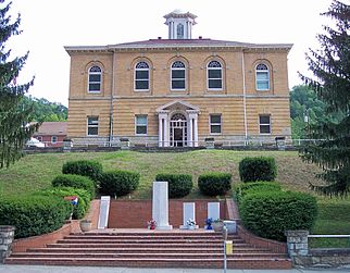 The Clay County Courthouse in 2007
Clay is a town in and the county seat of Clay County, West Virginia, United States.[3] The population was 593 at the 2000 census. It is the only incorporated town in Clay County.
Contents
History
Clay was established on the site of a farm that was the site of Clay County's first court meeting following the county's establishment in 1858. The community was initially known by the name of "Marshall," then briefly as "Henry," and then as "Clay Courthouse" and finally Clay. The town and county are both named for U.S. Senator and Secretary of State Henry Clay[4](1777–1852).
Geography
Clay is located at 38°27′46″N 81°4′48″W / 38.46278°N 81.08°W (38.462855, -81.080024),[5] along the Elk River,[6] at an elevation of 708 feet (216 m).[4]
According to the United States Census Bureau, the town has a total area of 0.6 square miles (1.6 km²). 0.6 square miles (1.5 km²) of it is land and 0.1 square miles (0.2 km²) of it (9.52%) is water.
Demographics
As of the census[1] of 2000, there were 593 people, 261 households, and 153 families residing in the town. The population density was 1,034.8 inhabitants per square mile (401.7/km²). There were 316 housing units at an average density of 551.4 per square mile (214.0/km²). The racial makeup of the town was 98.82% White, 0.17% Native American, and 1.01% from two or more races. Hispanic or Latino of any race were 0.17% of the population.
There were 261 households out of which 32.2% had children under the age of 18 living with them, 37.2% were married couples living together, 17.2% had a female householder with no husband present, and 41.0% were non-families. 39.1% of all households were made up of individuals and 19.2% had someone living alone who was 65 years of age or older. The average household size was 2.21 and the average family size was 2.91.
In the town the population was spread out with 27.8% under the age of 18, 9.1% from 18 to 24, 23.8% from 25 to 44, 22.3% from 45 to 64, and 17.0% who were 65 years of age or older. The median age was 35 years. For every 100 females there were 83.6 males. For every 100 females age 18 and over, there were 76.1 males.
The median income for a household in the town was $14,712, and the median income for a family was $15,000. Males had a median income of $25,893 versus $14,250 for females. The per capita income for the town was $11,415. About 47.3% of families and 39.1% of the population were below the poverty line, including 49.4% of those under age 18 and 12.5% of those age 65 or over.
References
- ^ a b "American FactFinder". United States Census Bureau. http://factfinder.census.gov. Retrieved 2008-01-31.
- ^ "US Board on Geographic Names". United States Geological Survey. 2007-10-25. http://geonames.usgs.gov. Retrieved 2008-01-31.
- ^ "Find a County". National Association of Counties. http://www.naco.org/Counties/Pages/FindACounty.aspx. Retrieved 2011-06-07.
- ^ a b Samples, Mack (2006). "Clay". In Ken Sullivan (ed.). The West Virginia Encyclopedia. Charleston, W.Va.: West Virginia Humanities Council. pp. 141. ISBN 0-9778498-0-5.
- ^ "US Gazetteer files: 2010, 2000, and 1990". United States Census Bureau. 2011-02-12. http://www.census.gov/geo/www/gazetteer/gazette.html. Retrieved 2011-04-23.
- ^ West Virginia Atlas & Gazetteer. Yarmouth, Me.: DeLorme. 1997. pp. 44. ISBN 0-89933-246-3.
External links
Municipalities and communities of Clay County, West Virginia County seat: Clay Town Clay

Unincorporated
communitiesAdonijah | Bentree‡ | Bickmore | Big Otter | Bomont | Dille | Duck | Floe | Fola | Glen | Harrison | Independence | Indore | Ivydale | Little Italy | Lizemores | Maysel | Nebo | O'Brion | Ovapa | Porter | Procious | Swandale | Valley Fork | Wallback‡ | Whetstone | Widen
Footnotes ‡This populated place also has portions in an adjacent county or counties
Categories:- Populated places in Clay County, West Virginia
- County seats in West Virginia
- Towns in West Virginia
- Charleston, West Virginia metropolitan area


Wikimedia Foundation. 2010.