- Conconully, Washington
-
Conconully, Washington — Town — Overview of Conconully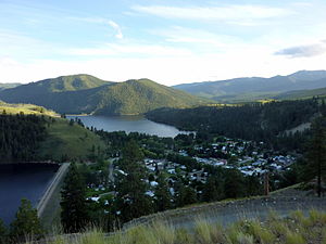 Location of Conconully, Washington
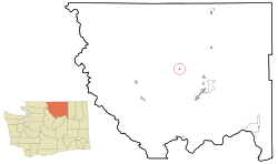
Coordinates: 48°33′32″N 119°45′4″W / 48.55889°N 119.75111°WCoordinates: 48°33′32″N 119°45′4″W / 48.55889°N 119.75111°W Country United States State Washington County Okanogan Area - Total 0.2 sq mi (0.6 km2) - Land 0.2 sq mi (0.6 km2) - Water 0.0 sq mi (0.0 km2) Elevation 2,303 ft (702 m) Population (2010) - Total 210 - Density 1,050/sq mi (322.1/km2) Time zone Pacific (PST) (UTC-8) - Summer (DST) PDT (UTC-7) ZIP code 98819 Area code(s) 509 FIPS code 53-14310[1] GNIS feature ID 1518000[2] Conconully is a town in Okanogan County, Washington, United States. The population was 210 at the 2010 census.
Contents
History
Conconully was officially incorporated on November 11, 1908. Was originally named Salmon City after the nearby Salmon Creek. It began as a gold miners camp.
Geography
Conconully is located at 48°33′32″N 119°45′4″W / 48.55889°N 119.75111°W (48.558820, -119.751054).[3]
According to the United States Census Bureau, the town has a total area of 0.2 square miles (0.6 km²), all of it land.
Demographics
As of the census[1] of 2000, there were 185 people, 94 households, and 53 families residing in the town. The population density was 834.3 people per square mile (324.7/km²). There were 192 housing units at an average density of 865.8 per square mile (337.0/km²). The racial makeup of the town was 96.22% White, 3.24% Native American, and 0.54% from two or more races.
There were 94 households out of which 13.8% had children under the age of 18 living with them, 47.9% were married couples living together, 6.4% had a female householder with no husband present, and 42.6% were non-families. 31.9% of all households were made up of individuals and 12.8% had someone living alone who was 65 years of age or older. The average household size was 1.97 and the average family size was 2.43.
In the town the population was spread out with 11.9% under the age of 18, 3.8% from 18 to 24, 21.6% from 25 to 44, 32.4% from 45 to 64, and 30.3% who were 65 years of age or older. The median age was 52 years. For every 100 females there were 107.9 males. For every 100 females age 18 and over, there were 103.8 males.
The median income for a household in the town was $23,214, and the median income for a family was $24,750. Males had a median income of $29,167 versus $22,000 for females. The per capita income for the town was $16,168. About 17.5% of families and 18.7% of the population were below the poverty line, including 21.7% of those under the age of eighteen and none of those sixty five or over.
References
- ^ a b "American FactFinder". United States Census Bureau. http://factfinder.census.gov. Retrieved 2008-01-31.
- ^ "US Board on Geographic Names". United States Geological Survey. 2007-10-25. http://geonames.usgs.gov. Retrieved 2008-01-31.
- ^ "US Gazetteer files: 2010, 2000, and 1990". United States Census Bureau. 2011-02-12. http://www.census.gov/geo/www/gazetteer/gazette.html. Retrieved 2011-04-23.
Municipalities and communities of Okanogan County, Washington County seat: Okanogan Cities 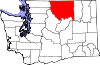
Towns Conconully | Coulee Dam ‡ | Elmer City | Nespelem | Riverside | Twisp | Winthrop
CDPs Unincorporated
communitiesIndian reservation Ghost towns Footnotes ‡This populated place also has portions in an adjacent county or counties
Categories:- Populated places in Okanogan County, Washington
- Towns in Washington (state)


Wikimedia Foundation. 2010.