- Montesano, Washington
-
- For other uses, see Montesano (disambiguation).
Montesano, Washington — City — Location of Montesano, Washington
Coordinates: 46°59′9″N 123°35′52″W / 46.98583°N 123.59778°WCoordinates: 46°59′9″N 123°35′52″W / 46.98583°N 123.59778°W Country United States State Washington County Grays Harbor Area – Total 10.4 sq mi (27.0 km2) – Land 10.3 sq mi (26.8 km2) – Water 0.1 sq mi (0.2 km2) Elevation 66 ft (20 m) Population (2010) – Total 3,976 – Density 320.4/sq mi (123.7/km2) Time zone Pacific (PST) (UTC-8) – Summer (DST) PDT (UTC-7) ZIP code 98563 Area code(s) 360 FIPS code 53-46895[1] GNIS feature ID 1511681[2] Website www.montesano.us Montesano is a city in Grays Harbor County, Washington, United States. The population was 3,976 at the 2010 census. It is the county seat of Grays Harbor County.[3]
Contents
History
Montesano was first settled in 1852 by Isaiah L. Scammon.[4]
According to Edmond S. Meany, in 1860 the county seat of what was then called Chehalis County was moved to "the place of J.L. Scammons". Mrs. Lorinda Scammon was very religious and wished to have the place named Mount Zion. Another early settler, Samuel James, suggested "Montesano" as having a more pleasant sound and meaning about the same. The suggestion was approved and soon after a post office was secured with the name Montesano.[5]
Geography
Montesano is located at 46°59′9″N 123°35′52″W / 46.98583°N 123.59778°W (46.985865, -123.597726).[6] It is on the north slope of the Chehalis River valley, near the confluence of the Wynoochee River and Chehalis River. The town is bordered on the North and west by Lake Sylvia and Sylvia Creek.
According to the United States Census Bureau, the city has a total area of 10.4 square miles (27.0 km²), of which, 10.3 square miles (26.8 km²) of it is land and 0.1 square miles (0.2 km²) of it (0.86%) is water.
Demographics
Historical populations Census Pop. %± 1890 1,632 — 1900 1,194 −26.8% 1910 2,488 108.4% 1920 2,158 −13.3% 1930 2,460 14.0% 1940 2,242 −8.9% 1950 2,328 3.8% 1960 2,486 6.8% 1970 2,847 14.5% 1980 3,247 14.0% 1990 3,060 −5.8% 2000 3,312 8.2% 2010 3,976 20.0% As of the census[1] of 2000, there were 3,312 people, 1,326 households, and 879 families residing in the city. The population density was 320.4 people per square mile (123.7/km²). There were 1,408 housing units at an average density of 136.2 per square mile (52.6/km²). The racial makeup of the city was 94.99% White, 0.12% African American, 1.87% Native American, 0.48% Asian, 0.06% Pacific Islander, 0.18% from other races, and 2.29% from two or more races. Hispanic or Latino of any race were 1.84% of the population.
There were 1,326 households out of which 30.9% had children under the age of 18 living with them, 51.4% were married couples living together, 10.5% had a female householder with no husband present, and 33.7% were non-families. 28.4% of all households were made up of individuals and 13.5% had someone living alone who was 65 years of age or older. The average household size was 2.38 and the average family size was 2.92.
In the city the population was spread out with 23.8% under the age of 18, 8.5% from 18 to 24, 28.7% from 25 to 44, 23.6% from 45 to 64, and 15.4% who were 65 years of age or older. The median age was 39 years. For every 100 females there were 99.4 males. For every 100 females age 18 and over, there were 96.2 males.
The median income for a household in the city was $40,204, and the median income for a family was $42,344. Males had a median income of $41,500 versus $30,096 for females. The per capita income for the city was $19,467. About 9.3% of families and 11.6% of the population were below the poverty line, including 12.4% of those under age 18 and 10.7% of those age 65 or over.
Attractions
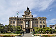 Grays Harbor County Courthouse
A prominent feature of the town is the 1911 Grays Harbor County Courthouse. This is a three-story structure with a domed tower. The interior features murals of local history. Not to be missed is the dent in the front door made by the Sheriff as he fired at a fleeing felon. The motto "come on vacation and leave on probation" has been coined for this Grays County city.
Bordering along the northern edge of the town is Lake Sylvia State Park. The park is located in dense boreal forest, almost temperate rain forest. The park offers swimming, hiking, camping, fishing, and boating, and was built around an old lumber mill pond, which was briefly the converted to power the town's first electrical generation plant. The park is home to a mixed flock of feral and wild mallard ducks, Canada Geese, a family of ospreys, as well as Bald Eagles. There is also a small group of beavers living along Sylvia Creek, which flows through the lake.
Wynooche Valley Road, the road north from Montesano which follows the course of the Wynoochee River, is the access way to the southern quarter of the Olympic National Park.
The annual Festival of Lights is a Holiday celebration that has gone strong for 22 years. Festivities include tours of decorated historic homes, a lighting contest, arts and crafts show, a children's play zone, food vendors, the jingle bell jog, a scavenger hunt, storytelling, tours of the county courthouse and murals, and a pancake breakfast. The highlight of the weekend is the Grand Parade. Other activities include the Yule Log lighting, chowder feed, and caroling.
The influential band Melvins were formed in the town. Nirvana lead singer and guitarist Kurt Cobain moved to Montesano with his father as a child, following the divorce of his parents in 1976. Cobain was shuttled between relatives until 1983 when he moved back to his mother's in Aberdeen, Washington, the city of his birth, during his sophomore year of high school.
References
- ^ a b "American FactFinder". United States Census Bureau. http://factfinder.census.gov. Retrieved 2008-01-31.
- ^ "US Board on Geographic Names". United States Geological Survey. 2007-10-25. http://geonames.usgs.gov. Retrieved 2008-01-31.
- ^ "Find a County". National Association of Counties. http://www.naco.org/Counties/Pages/FindACounty.aspx. Retrieved 2011-06-07.
- ^ Majors, Harry M. (1975). Exploring Washington. Van Winkle Publishing Co. p. 116. ISBN 9780918664006. http://books.google.com/books?id=CoWrPQAACAAJ.
- ^ Meany, Edmond S. (1920). "Origin of Washington Geographic Names". The Washington Historical Quarterly (Washington University State Historical Society) XI: 209. http://books.google.com/?id=dbsUAAAAYAAJ. Retrieved 2009-06-11.
- ^ "US Gazetteer files: 2010, 2000, and 1990". United States Census Bureau. 2011-02-12. http://www.census.gov/geo/www/gazetteer/gazette.html. Retrieved 2011-04-23.
Municipalities and communities of Grays Harbor County, Washington County seat: MontesanoCities Aberdeen | Cosmopolis | Elma | Hoquiam | McCleary | Montesano | Oakville | Ocean Shores | Westport

CDPs Aberdeen Gardens | Brady | Central Park | Chehalis Village | Cohassett Beach | Copalis Beach | Grayland | Humptulips | Junction City | Malone-Porter | Markham | Moclips | Neilton | Ocean City | Oyehut-Hogans Corner | Satsop | Taholah
Unincorporated
communitiesAmanda Park | Copalis Crossing | Pacific Beach | Quinault
Indian reservations Chehalis Indian Reservation‡ | Quinault Indian Reservation‡
Footnotes ‡This populated place also has portions in an adjacent county or counties
Categories:- Cities in Washington (state)
- Populated places in Grays Harbor County, Washington
- County seats in Washington (state)


Wikimedia Foundation. 2010.