- Washington Avenue Bridge (Minneapolis)
Infobox_Bridge
bridge_name=Washington Avenue Bridge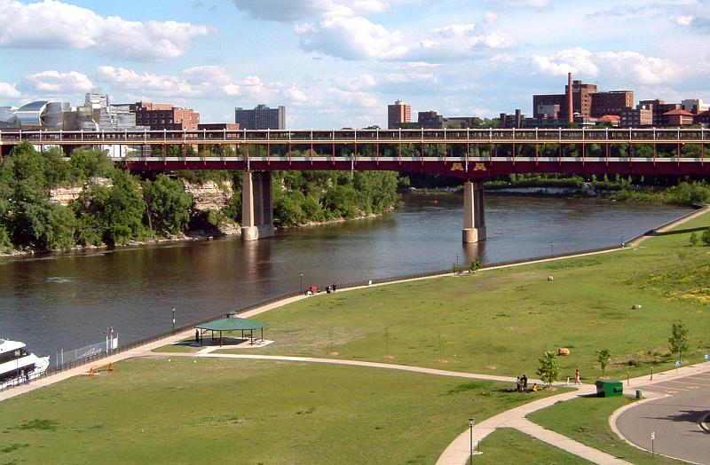
caption=The Washington Avenue Bridge in Minneapolis, looking south from NP Bridge #9
official_name=
crosses=Mississippi River
carries=Four lanes of County Road 122 on the lower deck,
bicycles and pedestrians on the upper deck
locale=Minneapolis, Minnesota
design=Plate girder bridge
mainspan=251 feet
length=1130 feet
width=Four lanes of traffic
below=70 feet
open=1965
maint=Minnesota Department of Transportation
id=9360
coordinates= coord|44|58|24|N|93|14|21|W|region:US_type:landmark
map_
map_width=300px
map_cue=Bridges over the Mississippi in Minneapolis/St. Paul.
map_text=Washington Ave. is about center on this image, between N. Pacific Bridge #9 and I-94The Washington Avenue Bridge carries County Road 122 across theMississippi River inMinneapolis, Minnesota and connects the East Bank and West Bank portions of theUniversity of Minnesota 's main campus. The bridge has two decks, with the lower deck designated for vehicle traffic and the upper level used for pedestrians and bicycles (lanes specifically for bikes are on the north side). It is a utilitarian structure with simplearchitecture , but it has cultural significance because thousands ofstudent s, faculty, staff, and visitors walk across it every day.History
An
iron truss bridge was first built here in 1884, slightly upstream from the current location (connecting Washington Avenue on both sides of the river). At the time of construction, many people lived in the river flats area below, a neighborhood known asBohemian Flats (See photo below). The bridge was strengthened in 1890 to accommodatestreetcar s, and it made up part of the first interurban line between Minneapolis and neighboring Saint Paul (seeTwin City Rapid Transit ). Streetcar service ended in 1954. Construction of the current bridge began in 1962. The 1884 bridge was torn down in 1965.This first structure was a straight east-west bridge carrying Washington Avenue, which continued directly into downtown. The new bridge aimed the west end slightly to the south, so Washington Avenue is now disjointed at that point. Continuing straight along the roadway will carry a vehicle into downtown along a short freeway-like section that meets 3rd Street South (a one-way—returning involves traveling along 4th Street). The roadway between Interstate 35W in the west and University Avenue in the east, which includes the bridge, was once designated as Minnesota State Highway 122, but that ended in 1997 when Hennepin County took over control of the roadway from the
Minnesota Department of Transportation . Returning to Washington Avenue after crossing the bridge requires taking the first exit upon reaching the west side, or turning north after reaching downtown.The top deck on the new bridge was originally just a flat space. Traversing the bridge in the harshness of
winter was very uncomfortable, so an enclosure running down the center of the pedestrian area was added by the 1970s. Originally meant to be aheated indoor pedestrian area, due to energy cost concerns, the walkway is mostly unheated. There are some heaters inside that keep the area slightly warmer than outside, and some heat loss from the steam mains, but it can still dip below the freezing point. The structure also adds awindbreak for the top level, improving conditions for people who choose to walk outside. In the summer, large overhangs also provide some shade.At least one designer had much grander plans. Winston Close, an adviser from the university to the architectural team, envisioned modeling the top level on the
Ponte Vecchio bridge inFlorence, Italy . This would have included shops, making the bridge a place to stay rather than just get across. Some effort has been put into making the site a more inviting place. The addition of the upper deck enclosure led to an annual artistic event held on the first few days of classes, where organizations of all stripes can put their brushes to panels lining the interior. While most are self-promotional messages from campus groups, some of the panels always show impressive designs.The exterior of the bridge had been a rather
drab combination ofbrown andgray for most of its existence. Some felt that it was off-balance in its university surroundings, especially after theFrank Gehry -designedWeisman Art Museum went into place next to the east end in the 1990s. University PresidentMark Yudof led a "Take Pride in U" campaign in 1997 where the top level was painted in theschool colors of maroon and gold. Later, in the first decade of the 2000s, thesuperstructure was also painted over the course of about two years. This had to be arranged with Hennepin County, which owns the bridge. It took such a long time because the old paint contained lead and had to be carefully removed.A darker facet of the bridge's history is its association with
suicide .Poet and universityprofessor John Berryman is the most famous person to have killed himself at the site, when he jumped from the bridge in 1972. About a half-dozen others have also died by landing in the river or on the flats area. It is also thought by many that this bridge is haunted by one or moreghosts . Many students have reported experiencing unexplained sounds of footsteps behind them, cold spots, and other phenomena.2008 Repairs and Pedestrian Level Restrictions
In August 2008, concerns about the strength of the upper level led Hennepin County to restrict the pedestrian and bicycle traffic to a 14-foot-wide section in the center. Engineers had decided that in preparation for repairs, the weight needed to be moved to the center, where there was support from the columns below. [ [http://www.startribune.com/local/minneapolis/27301229.html?elr=KArksDyycyUtyycyUiD3aPc:_Yyc:aUU Safety concerns prompt traffic limits on U bridge] ]
Future
The bridge may be replaced or substantially improved. In particular, plans for a new Central Corridor transit link to Saint Paul must take this span into account.
ee also
*
List of crossings of the Upper Mississippi River References
*Peter Ritter (February 24, 1999). [http://www.citypages.com/databank/20/951/article7236.asp Water Under a Troubled Bridge.] "
City Pages ".
*Scott F. Anfinson (1989). [http://www.fromsitetostory.org/sources/papers/mnarch48/48inv-ib.asp Archaeology of the Central Minneapolis Riverfront.] "The Minnesota Archaeologist", Vol. 48, No. 1-2.Minnesota Historical Society .
*Steve Riner [http://www.steve-riner.com/mnhighways/r101-149.htm#122 Details of Routes 101-149.] Unofficial Minnesota Highways Page.
*Erin Ghere (March 29, 1999). [http://www.mndaily.com/daily/1999/03/29/news/paint/ Bridge repainting project causes traffic concerns.] "The Minnesota Daily ".
* cite book
last = Costello
first = Mary Charlotte
authorlink =
coauthors =
year = 2002
title = Climbing the Mississippi River Bridge by Bridge, Volume Two: Minnesota
publisher = Adventure Publications
location = Cambridge, MN
id = ISBN 0-9644518-2-4Crossings navbox
structure = Bridges
place =Mississippi River
bridge = Washington Avenue Bridge
bridge signs =
upstream =Northern Pacific Bridge Number 9
upstream signs =
downstream =Dartmouth Bridge
downstream signs =

Wikimedia Foundation. 2010.