- Masthouse Terrace Pier
-
 London River Services
Masthouse Terrace Pier 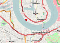
Location of Masthouse terrace Pier on the Isle of DogsLocale River Thames, London, UK Transit type River bus services Owner London River Services Operator London River Services London River Services - City Cruises
- London Eye
- Bateaux London
- Crown River Cruises
- Lower Thames & Medway
- Woolwich Ferry
- Thames Clipper
- Thames Executive Charters
- Thames River Services
- Turks Launches
- Westminster Passenger Services
- Waverley Excursions
Masthouse Terrace Pier is a pier on the River Thames in London, UK. It is located at the end of Napier Avenue, off Westferry Road, at the southern end of the Isle of Dogs, and provides river bus services managed by London River Services.
Services
Masthouse Terrace is a stop on the Thames commuter catamaran service run by Thames Clipper from Embankment, via Tower Millennium Pier, Canary Wharf and on to Greenwich, the O2 and Woolwich Arsenal Pier.
Masthouse Terrace Pier temporarily closed between 14 January 2008 and 26 April 2008 for renovation work carried out by British Waterways, at a cost of £500,000. Transport for London provided a grant of £400,000 towards this work. The refurbishment work included installation of CCTV, a new waiting shelter, maintenance and repainting work.[1]
Transport connections
Masthouse Terrace Pier is about a ten-minute walk from either Mudchute or Island Gardens DLR stations, and is on the north bank of the Thames Path. Local buses include the D7 bus.
References
- ^ "Masthouse Terrace pier temporary closure". Thames Clippers. 2008-01-10. http://www.thamesclippers.com/article/201. Retrieved 2008-04-03.
Preceding station London River Services Following station Greenland Dock Piertoward Embankment PierCommuter Service toward Woolwich Arsenal PierCoordinates: 51°29′15″N 0°01′20″W / 51.48753°N 0.022187°W
Categories:- London River Services
- Transport in Tower Hamlets
- Piers in London
- London building and structure stubs
- London Transport stubs

Wikimedia Foundation. 2010.