- U.S. Route 395 in Washington
-
This article is about the section of U.S. Route 395 in Washington. For the entire length of the highway, see U.S. Route 395.
U.S. Route 395
Route information Defined by RCW 47.17.575 Maintained by WSDOT and BCMoTI Length: 277.11 mi[1] (445.97 km) Major junctions South end: 
 I-82 / US 395 in Umatilla, OR
 I-182 / US 12 in Pasco

 I-90 / US 2 in Spokane
North end:  BC 3 near Christina Lake, BC
Highway system United States Numbered Highways
List • Bannered • Divided • ReplacedState highways in Washington
Interstate • US • State
Former PSH • 1964 renumbering • Former SR←  SR 339
SR 397  →
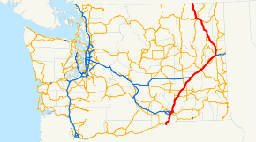
→In the U.S. state of Washington, U.S. Route 395 is a major state highway in two parts, separated by a long overlap with Interstate 90 between Ritzville and Spokane. The southern piece, from I-82 near the Tri-Cities to I-90 near Ritzville, is a high-speed four-lane divided highway. From Spokane to the Canada – United States border at Laurier, US 395 is mostly two lanes, with some wider sections near Spokane, including the under-construction North Spokane Corridor freeway.[2]
Contents
Route description
The section of US 395 within the state of Washington starts concurrent with I-82 on the Umatilla Bridge, which goes over the Columbia River. From the bridge, the US 395/I-82 freeway goes north and intersects SR 14's eastern terminus before continuing north and spliting from I-82. As US 395 splits, the freeway enters Kennewick, where it intersects SR 240 and crosses the Columbia River on the Blue Bridge.[3]
As the bridge ends, US 395 enters Pasco and joins I-182 and US 12 before exiting north at an interchange with SR 397. From the interchange, US 395 continues north on the eastern side of the Tri-Cities Airport towards Spokane. US 395 goes northeast and intersects numerous state highways, such as SR 17 in Mesa, SR 260 in Connell, SR 26 east of Hatton, and SR 21 east of Lind before joining I-90 south of Ritzville.[4]
While concurrent with I-90, US 395 intersects more highways such as SR 261 south of Ritzville, SR 23 in Sprague, SR 904 in Tyler, SR 902 west of Cheney, SR 904 in Four Lakes, and SR 902 in Hayford before joining US 2 and entering Spokane.[5]
In West Spokane, US 395/I-90/US 2 intersects the northern terminus of US 195 before US 395 and US 2 split from I-90 in Downtown Spokane. US 395 and US 2 stay joined on Division Street through Downtown Spokane where the highway intersects SR 290 and pass Gonzaga University and Washington State University's Spokane branch. After entering the northern section of Spokane, US 395 and US 2 pass the NorthTown Mall and intersect SR 291 before US 395 splits from US 2 and continues north.[6]
From the Division split, US 395 goes north and intersects more highways like SR 292 in Loon Lake, and SR 231 south of Chewelah before joining SR 20 in Colville and continuing west and intersecting SR 25 in Kettle Falls before splitting from SR 20 and going north. From the split, US 395 goes north to Laurier where it reaches the Canada – United States border.[7][8][9]

Upon crossing the border, the highway becomes BC Highway 395, commissioned in 1973, and goes for 4 kilometres (2.5 mi) to its terminus at a point on the Crowsnest Highway at the southern end of Christina Lake.
History
Oregon to Pasco
When US 395 was extended southwest from Spokane into Oregon in the 1930s, it followed existing U.S. Highways - US 730 and US 410 - between the state line and Pasco;[10][11] it was not realigned to the more direct route via Kennewick until 1985.[12] However, the road from Plymouth to Kennewick, cutting off a bend in the Columbia River, had existed (as a county road) since the early days of the state highway system,[13] and was improved by the 1930s.[10] The Washington State Legislature added the roadway to the state highway system in 1943 as part of a Maryhill-Kennewick branch of Primary State Highway 8.[14] (The main route of PSH 8 turned northeast from Maryhill to Buena via US 97.)
Pasco to Spokane
 A map of Primary State Highway 11
As part of the state's first connected state highway system, the Washington State Legislature designated the Central Washington Highway between Pasco and Spokane in 1913.[15] The State Highway Board selected a route closely paralleling the Northern Pacific Railway's Pasco Division over existing county roads.[13][16] In 1923, by which time the entire road had been improved,[17] the highway became State Road 11 (Primary State Highway 11 after 1937), but retained its name (which was changed to Columbia Basin Highway in 1929).[18][19] By that time, several routing changes had been made, with the State Highway Board moving the highway east away from the rail line between Eltopia and Connell and between Connell and Lind, and changing the direct northeasterly route from Cheney to Spokane to a northerly route enting at the Sunset Highway (now US 2) near Airway Heights.[20] In the 1930s, US 395 was extended southwest from Spokane along SR 11 to Pasco, where it continued southeast on US 410 (now US 12) and southwest on US 730 into Oregon, both branches of State Road 3.[10][11] US 10 was moved south between Cle Elum and Spokane in 1940, overlapping US 395 northeast of Ritzville.[citation needed]
Near Spokane, the Geiger Boulevard cutoff was built in about 1945 as a wartime project, improving access to Geiger Field. This included an interchange with Sunset Highway at the Spokane end.[21][22] This roadway, and the rest of US 395 between Ritzville and Pasco, was replaced by a freeway in the 1950s and 1960s, as part of the project to turn US 10 into Interstate 90. The first section to open was the bypass of Ritzville to Tokio in the late 1950s, and the final piece was between Tokio and Tyler in the late 1960s.[22] When the bypass of Cheney opened on November 18, 1966,[23] the old route became a short-lived Secondary State Highway 11H,[24] always signed as State Route 904.[25]
As the first phase of converting US 395 between Pasco and Ritzville into a limited-access highway, the Department of Highways constructed a new a two-lane alignment between Connell and east of Lind in the mid-1950s, bypassing Lind and Foulkes Roads northeast from Connell and Wahl Road south from Lind.[22][26] Another relocation was built in about 1980, moving the highway alongside the rail line between Eltopia and Connell.[22] The southernmost 7.5 miles (12 km) of SR 17, from Eltopia to Mesa, were absorbed into the realignment; SR 17's mileposts now begin at about 7.5.[1] By 1991, when the Intermodal Surface Transportation Efficiency Act designated US 395 between Reno, Nevada and Canada as a high priority corridor of the National Highway System, and earmarked $54.5 million for improvements in Washington,[27] the portion between Pasco and Mesa had been four-laned. That year, the state began an $83 million project, including $10.4 million more from the federal government, to widen the remainder north to Ritzville from two to four lanes. Several interchanges were also added to the road, then one of the state's most dangerous highways. WSDOT formally opened the last piece, 15 miles (24 km) of new northbound lanes near Lind, on November 21, 1995, completing a four-lane cross section between the Tri-Cities and Spokane.[28] The speed limit was subsequently raised from 55 to 70 miles per hour (90 to 115 km/h) in July 1996, based on road conditions and actual driving speed.[29]
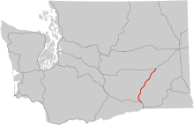
Spokane to Canada
Before the reconfiguration of 2nd and 3rd Avenues in 1951, the original routing of US 395 in Spokane ran northbound on Monroe Street for several miles, crossing the Monroe Street Bridge at Spokane Falls. After turning right onto Garland Avenue, the highway proceeded on North Wall Street, North Waikiki Road, and North Mill Road before returning to modern-day US 395. The southern end of the highway was moved up to the intersection of Sprague and Monroe in 1930 while the entire highway was shifted east onto Division Street (US 2) in 1937. Sometime in the 1950s, the southbound lanes were relocated to Browne Street, which is immediately due south of the Spokane River. A major portion of the highway from the US 2 junction to Colville has been realigned and straightened over the years, including sections near Loon Lake, Chewelah, and Arden. The largest bypass was that of Loon Lake, which was built in 1957. Another bypass circumvented Old US 395 around Springdale. That highway eventually became SR 231 while its spur was officially dubbed SR 292. Further north near the town of Arden, a new highway section was built that paralleled the Old Arden Highway, which is now used mostly by local traffic. The last leg of US 395, from Colville to the Canada – United States border, has maintained almost exactly the same alignment since it was originally built. A pair of bridges linking Stevens County to Ferry County, known as the Kettle Falls Bridges, were constructed in 1941 in the vicinity of Kettle Falls over the Columbia River. After passing through some dense forest, the highway finally ends its journey at the border station in Laurier; where the highway transitions itself onto British Columbia Highway 395. In recent years, a number of changes have been made to address growing traffic issues; including (but not limited to) the addition of left-turn channelization at important intersections, a variety of different paving projects, the construction of two roundabouts in downtown Colville, and the addition of uphill passing lanes in some places. Probably the most important construction project to date is the aforementioned North Spokane Corridor, which intends to address and alleviate a major chokepoint along the state highway system in metropolitan Spokane. The maximum speed limit along the entire route is 60 miles per hour.
References
- Kaiser, C (2009). [1] "US 395, Part 28: Spokane and Northern Spokane County (US 2/US 395 and US 395)"
Major intersections
County Location Mile[1] # Destinations Notes Benton 0.00 Umatilla Bridge over the Columbia River (state line) 1.00 131  SR 14 west – Plymouth, Vancouver
9.84 122 Coffin Road 18.19 114 Locust Grove Road (I-82 to SR 397 Intertie) 19.81 I-82 west – YakimaNorth end of I-82 overlap 20.54 North end of freeway Kennewick 23.68 Kennewick Avenue – Kennewick City Center 24.35 South end of freeway 25.01 Columbia Drive – Port of Kennewick /  SR 240 west – Richland
25.01 SR 240 west – RichlandSouthbound exit and northbound entrance 25.69 Blue Bridge over the Columbia River Franklin Pasco 26.09 Lewis Street Northbound exit and southbound entrance 26.27 Sylvester Street Northbound exit only 26.80 Court Street 27.35 I-182 west / US 12 west – Richland, YakimaSouth end of I-182/US 12 overlap 27.79 12B North 20th Avenue – Columbia Basin College 28.87 13 North 4th Avenue – Pasco City Center 29.48 14A SR 397 south (Oregon Avenue) – Finley29.48 US 12 east – Walla Walla, LewistonNorth end of I-182/US 12 overlap 30.45 Kartchner Street 31.87 North end of freeway 44.13 Eltopia West Road – Eltopia 44.13 South end of freeway Mesa 52.65  SR 17 north – Mesa, Moses Lake
Connell 61.64  SR 260 – Connell, Kahlotus
63.22 North end of freeway 63.22 Lind Road – Connell 67.68 South end of freeway Adams 72.86  SR 26 – Colfax, Othello
77.15 Gap in freeway 88.70  SR 21 – Lind, Kahlotus
94.10 Paha, Packard 102.04 Ritzville 102.69 I-90 west – SeattleSouth end of I-90 overlap; northbound exit is via Ritzville exit 103.87 221  SR 261 south – Ritzville, Washtucna
108.34 226 Schoessler Road 113.15 231 Tokio Lincoln Sprague 127.18 245  SR 23 – Sprague, Harrington
135.94 254 Fishtrap Spokane 139.61 257  SR 904 east – Tyler, Cheney
146.22 264  SR 902 east – Cheney, Medical Lake
152.47 270 SR 904 west – Four Lakes, Cheney154.73 272 SR 902 west – Medical Lake158.24 276  I-90 Bus. east – Spokane, Geiger Field
159.65 277B US 2 west – Spokane Airport, Fairchild AFB, DavenportSouth end of US 2 overlap; signed as exit 277 southbound 160.12 277A Garden Springs Signed as exit 277 southbound; no entrance ramps Spokane 161.26 279  US 195 south – Colfax, Pullman
162.08 280A Maple Street Signed as exit 280 northbound 280B Lincoln Street Northbound exit is via exit 280 163.24 I-90 east – Coeur d'AleneNorth end of I-90 overlap 163.77 Spokane Falls Boulevard Former SR 290 east 167.59  SR 291 north – Tum Tum
169.27 US 2 east (Newport Highway) – NewportNorth end of US 2 overlap 171.78 Wandermere Road 171.78 South end of freeway 173.89 Hatch Road 175.89 North end of freeway 184.32 Main Avenue – Deer Park Stevens 195.37  SR 292 – Loon Lake, Springdale
203.31 Bulldog Creek Road Former SR 232 207.22  SR 231 – Valley, Springdale
Colville 234.41  SR 20 east – Ione, Newport
South end of SR 20 overlap 243.91  SR 25 – Davenport, Northport, Trail
Ferry 246.66 SR 20 west – Republic, TonasketNorth end of SR 20 overlap 262.63 Boulder-Deer Creek Road – Curlew Laurier 275.03 Canada – United States border References
- ^ a b c Washington State Department of Transportation, State Highway Log, 2006
- ^ Google, Inc. Google Maps – U.S. Route 395 Map (Overview) (Map). Cartography by Google, Inc. http://maps.google.com/maps?f=d&hl=en&geocode=6148851770216159538,45.931720,-119.328370&saddr=I-82+W%2FUS-395+N+%4045.931720,+-119.328370&daddr=49.000098,-118.224306&mra=mi&mrsp=1,0&sz=14&doflg=ptm&sll=48.998522,-118.22525&sspn=0.016049,0.033646&ie=UTF8&ll=47.768868,-118.234863&spn=4.208578,8.613281&z=6. Retrieved 2008-07-24.
- ^ Google, Inc. Google Maps – U.S. Route 395 (Plymouth to Kennewick) (Map). Cartography by Google, Inc. http://maps.google.com/maps?f=d&hl=en&geocode=6148851770216159538,45.931720,-119.328370&saddr=I-82+W%2FUS-395+N+%4045.931720,+-119.328370&daddr=46.224829,-119.135914&mra=mi&mrsp=1,0&sz=15&doflg=ptm&sll=46.226195,-119.134669&sspn=0.008461,0.016823&ie=UTF8&ll=46.145589,-119.182434&spn=0.54232,1.07666&z=9. Retrieved 2008-07-23.
- ^ Google, Inc. Google Maps – U.S. Route 395 Map (Kennewick to Ritzville) (Map). Cartography by Google, Inc. http://maps.google.com/maps?f=d&hl=en&geocode=16769152575727669549,46.224818,-119.135859%3B1825537321276580515,47.107620,-118.396031&saddr=US-395+S+%4046.224818,+-119.135859&daddr=46.224503,-119.134369+to:US-395+N+%4047.107620,+-118.396031&mra=dpe&mrcr=0&mrsp=1&sz=11&via=1&doflg=ptm&sll=46.242077,-119.090424&sspn=0.135344,0.269165&ie=UTF8&ll=46.845164,-119.058838&spn=2.141455,4.306641&z=7. Retrieved 2008-07-23.
- ^ Google, Inc. Google Maps – U.S. Route 395 Map (Ritzville to West Spokane) (Map). Cartography by Google, Inc. http://maps.google.com/maps?f=d&hl=en&geocode=1825537321276580515,47.107620,-118.396031%3B3942522168201694042,47.633643,-117.480098&saddr=US-395+N+%4047.107620,+-118.396031&daddr=47.63334,-117.480454&mra=dme&mrcr=0&mrsp=1&sz=16&doflg=ptm&sll=47.634352,-117.478652&sspn=0.004121,0.008411&ie=UTF8&ll=47.494937,-118.042603&spn=1.057739,2.15332&z=8. Retrieved 2008-07-23.
- ^ Google, Inc. Google Maps – U.S. Route 395 Map (West Spokane to North Spokane) (Map). Cartography by Google, Inc. http://maps.google.com/maps?f=d&hl=en&geocode=3747103784443344840,47.633250,-117.480335%3B10514557170221630101,47.740062,-117.411043&saddr=I-90+E+%4047.633250,+-117.480335&daddr=47.740074,-117.411919&mra=dme&mrcr=0&mrsp=1&sz=14&doflg=ptm&sll=47.736206,-117.415009&sspn=0.016452,0.033646&ie=UTF8&ll=47.688966,-117.431488&spn=0.131732,0.269165&z=11. Retrieved 2008-07-23.
- ^ Google, Inc. Google Maps – U.S. Route 395 Map (North Spokane to Colville) (Map). Cartography by Google, Inc. http://maps.google.com/maps?f=d&hl=en&geocode=1573898959352794798,47.739780,-117.411430&saddr=N+Division+St%2FUS-2+E%2FUS-395+N+%4047.739780,+-117.411430&daddr=48.546615,-117.906132&mra=mi&mrsp=1&sz=13&doflg=ptm&sll=48.545819,-117.899094&sspn=0.032388,0.067291&ie=UTF8&ll=48.42191,-117.037354&spn=2.077808,4.306641&z=7. Retrieved 2008-07-23.
- ^ Google, Inc. Google Maps – U.S. Route 395 Map (Colville to Canada) (Map). Cartography by Google, Inc. http://maps.google.com/maps?f=d&hl=en&geocode=17655047436001117084,48.546570,-117.905840&saddr=N+Main+St+%4048.546570,+-117.905840&daddr=49.000155,-118.223963&mra=mi&mrsp=1&sz=14&doflg=ptm&sll=49.000324,-118.227139&sspn=0.016048,0.033646&ie=UTF8&ll=48.783342,-118.01239&spn=0.515769,1.07666&z=9. Retrieved 2008-07-23.
- ^ Washington State Department of Transportation. Official State Highway Map [map], 2008-2009 edition, Official State Highway Maps. (2008) Retrieved on July 23, 2008
- ^ a b c Department of Highways, Highway Map: State of Washington, Revised to April 1, 1933
- ^ a b Department of Highways, Highways of the State of Washington (Rand McNally), 1939
- ^ Session Laws of the State of Washington. 1985 chapter 177. "An act relating to state highway routes; amending RCW 47.17.055, 47.17.060, 47.17.455, and 47.17.575; adding a new section to chapter 47.17 RCW; and repealing RCW 47.17.281 and 47.17.867."
- ^ a b State Highway Board, Road Map of Washington Showing Main Traveled Roads, 1912
- ^ Session Laws of the State of Washington. 1943 chapter 239, p. 715. "An act relating to public highways; creating and establishing, describing and designating additions to the Primary State Highways of the State of Washington; eliminating certain Secondary State Highways from the Secondary State Highway System; amending sections 2, 3 and 12, chapter 207, Laws of 1937 (sections 6402-2, 6402-3 and 6402-12, Remington's Revised Statutes, Volume 7A); and declaring an emergency and that this act shall take effect April 1, 1943.": "There is hereby established an extension to Primary State Highway No. 8, described as follows: Beginning in the vicinity of Maryhill, running thence easterly by the most feasible route along the north bank of the Columbia river to a point in the vicinity of Plymouth, thence in a northeasterly direction to a junction with Primary State Highway No. 3 in the vicinity of Kennewick."
- ^ Session Laws of the State of Washington. 1913 chapter 65, p. 222. "An act relating to public highways, classifying the same and naming and fixing the routes of certain state roads.": "A highway connecting with the Inland Empire Highway at Pasco, Washington; thence by the most feasible route through Connell, Ritzville, Sprague, and Cheney to Spokane, Washington, to be known as the Central Washington Highway."
- ^ State Highway Board, Map of Washington State Highways Authorized by Legislative Acts of 1913 (with 1915 changes marked)
- ^ Rand McNally, Official 1923 Auto Trails Map, District No. 14: Washington, Oregon, Northern California, Western Idaho
- ^ Session Laws of the State of Washington. 1923 chapter 185, p. 630. "An act relating to, classifying, naming and fixing the routes of certain state highways, amending Section 6796, and repealing Sections 6791, 6792, 6793, 6794, 6795, 6797, 6798, 6799, 6800, 6801, 6802, 6803, 6804, 6805, 6806, 6808, 6809, 6811, 6812, 6813 and 6816 of Remington's Compiled Statutes.": "A primary state highway, to be known as State Road No. 11 or the Central Washington Highway, is established as follows: Beginning at Pasco in Franklin County; thence by the most feasible route in a northeasterly direction through Connell, Ritzville, Sprague and Cheney to a connection with State Road No. 2 west of the City of Spokane."
- ^ Session Laws of the State of Washington. 1929 chapter 171, p. 432. "An act establishing a primary state highway to be known as State Road No. 11, or the Columbia Basin Highway, and amending Section 10 of Chapter 185 of the Laws of 1923."
- ^ State Highway Committee, Program of State Highway Department: State and Federal Aid System to be completed by 1936, Approved by State Highway Committee April 1, 1924
- ^ Department of Highways, Twenty-First Biennial Report, 1944-1946, p. 31: "the construction of Portland cement concrete pavement on PSH No. 11 between Geiger Field and Four Lakes, a distance of 2.888 miles"
- ^ a b c d National Bridge Inventory database, 2006
- ^ Department of Highways, Official Opening, Spokane Freeway, Four Lakes to Tyler, November 18, 1966, OCLC 41812460
- ^ Session Laws of the State of Washington. 1961 (1st extraordinary session) chapter 21, p. 2625. "Relating to public highways; describing powers and duties of the interim committee on highways, streets and bridges, license department and state highway commission; establishing and designating certain highways and alternate routes; providing for surveys and studies of proposed highway additions and toll facilities; prescribing fees, size, weight, load, permits and equipment restrictions for certain motor vehicles; prescribing regulations relating to motor vehicle fuel taxes; amending...; making appropriations; providing effective dates and declaring an emergency.": "Secondary state highway No. 11H; beginning at a junction with primary state highway No. 11 in the vicinity of Tyler, thence northeasterly via Cheney to a junction with primary state highway No. 11 in the vicinity of Four Lakes: Provided, That the addition of highway No. 11H shall not become effective until such time as the interstate system by-pass of Cheney is constructed and under traffic."
- ^ From 1964 to 1970, the old numbers remained legislatively but only the new numbers were signed.
- ^ Tri-City Herald, Lind By-Pass Will Straighten Kinks, August 21, 1956
- ^ 1991, H.R.2950. "An act to develop a national intermodal surface transportation system, to authorize funds for construction of highways, for highway safety programs, and for mass transit programs, and for other purposes."
- ^ Spokane Spokesman-Review, 4-Lane Road Completed at Lind, November 22, 1995
- ^ Spokane Spokesman-Review, State Highway Speed Limits Get a Boost, July 12, 1996
U.S. Route 395Previous state:
OregonWashington Next state:
TerminusState highways in Washington related to US 395  Former or proposed: SR 294
 U.S. Routes in Washington
Adams County, Washington Highways Categories:- U.S. Highways in Washington (state)
- U.S. Route 95
- Transportation in Benton County, Washington
- Transportation in Franklin County, Washington
- Transportation in Adams County, Washington
- Transportation in Lincoln County, Washington
- Transportation in Spokane County, Washington
- Transportation in Stevens County, Washington
- Transportation in Ferry County, Washington


Wikimedia Foundation. 2010.