- Dokis 9, Ontario
-
Dokis 9 — Indian reserve — 
 Dokis 9
Coordinates: 46°08′N 80°03′W / 46.133°N 80.05°WCoordinates: 46°08′N 80°03′W / 46.133°N 80.05°W Country  Canada
Province  Ontario
District Parry Sound Settled 1890s Formed 1850 Government - Chief Denise Restoule - Federal riding Parry Sound—Muskoka - Prov. riding Parry Sound—Muskoka Area[1] - Land 153.16 km2 (59.1 sq mi) Population (2006)[1] - Total 195 - Density 1.3/km2 (3.4/sq mi) Time zone EST (UTC-5) - Summer (DST) EDT (UTC-4) Postal Code P0M 2K0 Area code(s) 705 Website www.dokisfirstnation.com Dokis 9 is a First Nations reserve and community in the Canadian province of Ontario, assigned to the Dokis First Nation. The reserve is located approximately 16 kilometers southwest of central southern Lake Nipissing along the French River. It is divided into two large parts consisting of a north island, Okikendawt, and a large southern peninsula. The two land masses, which are nestled within the flows of the French river, cover approximately 158 square kilometers. The French River watershed in Northern Ontario was created more than ten thousand years ago when the last ice-age receded and left a maze of rivers and small lakes.[2] The main settlement is found on Okikendawt island (meaning island of buckets or island of pails) which can be accessed by a gravel road which connects with Highway 64.[3] The Land is occupied by the Dokis and its cousin tribe, the Restoule‘s. The land is well known for its hunting, fishing, fur trades, and timber.[4]
Contents
History
In 1850, Michel “Eagle” Dokis signed the Robinson Huron Treaty. At this time the Dokis were operating a successful fur trading enterprise at Dokis point on Lake Nipissing, which is located at the west end of Nipissing First Nation. It wasn’t until the 1890s, as the trading business slowed significantly, that the Dokis moved onto the land they negotiated for and Dokis Village was established. The Restoules, a related tribe of the Dokis, also started inhabiting Dokis Village and surrounding lands. Both families grew vegetable and grain crops while maintaining some trapping activities. In 1909 pressure was put on the tribes to sell the timber rights of the Dokis lands and lumbering became a new revenue.[5] The sale of their timber rights in 1909 made the Dokis the richest natives in Canada at that time.[6]
Demographics
As of March 2011, the registered population of the dokis First Nation is 991 members, of whom 168 live on the reserve, 2 live on another reserve, and 821 live off reserve.[7]
Canada census – Dokis 9, Ontario Community Profile 2006 2001 Population:
Land area:
Population density:
Median age:
Total private dwellings:
Mean household income:195 (-0.5% from 2001)
153.16 km2 (59.14 sq mi)
1.3 /km2 (3.4 /sq mi)
40.2 (males: 41.0, females: 39.5)
127196 (20.2% from 1996)
153.15 km2 (59.13 sq mi)
1.3 /km2 (3.4 /sq mi)
36.7 (males: 37.7, females: 36.0)
102Population trend:[10]
- Population in 2006: 195
- Population in 2001: 196
- Population in 1996: 163
- Population in 1991: 165
Attractions
The French River Provincial Park protects most of the land along the French River except for the land occupied by the Dokis. Today, over 300 years after fur traders first navigated its waters, motorboats, kayaks, and canoes now travel the French River; lodges and cottages dot the landscape, and it provides an abundance of activities for anglers and hunters. For much of its length, the French River is a broad, tree-lined expanse of open water. It also features falls, rapids, and steep, narrow gorges. The difficult topography of the Canadian Shield supports more than 450 plant species, some of them rare. The Massassauga rattlesnake, the only poisonous snake in Ontario, is also found in this area. Deers, mooses, elks and bears are some of the larger mammals in the area. Woodpeckers, ravens, Great Blue Herons and a variety of warblers are just some of the birds that can be found along the river’s shores.[11]
Fishing
Fish is a very important resource of the Dokis. The French River inhabits many fish including: Sturgeon, walleye, musky, northern pike, smallmouth bass, rock bass, perch, catfish, and whitefish. The Dokis still use spearing and netting as techniques for catching fish today.[12]
Economy
The Dokis’s economy is derived from a number of sources including small locally owned businesses. Private and tribe owned enterprises include businesses in construction, marina operation, catering, restaurants, transportation, tourism, eco-tourism, ecology, forestry, and services to cottage owners along the French River. Some Dokis First Nation Businesses include: Cold Springs Camp, Dokis Marina and Restaurant, Migisi Marina, Riverview Cottages, Tinny’s Taxidermy, and Young Forestry Services.[13]
References
- ^ a b "Dokis 9 community profile". 2006 Census data. Statistics Canada. http://www12.statcan.gc.ca/census-recensement/2006/dp-pd/prof/92-591/details/page.cfm?Lang=E&Geo1=CSD&Code1=3549077&Geo2=PR&Code2=35&Data=Count&SearchText=dokis&SearchType=Begins&SearchPR=01&B1=All&Custom=. Retrieved 2011-04-11.
- ^ http://www.tpsgc-pwgsc.gc.ca/ontario/eaux-water/index-eng.html
- ^ http://www.Dokisfirstnation.com
- ^ http://www.dokisfirstnation.com/dokishistory.html
- ^ http://www.dokisfirstnation.com/dokishistory.html
- ^ http://www.dokisfirstnation.com/aboutdokis.html
- ^ Indian and Northern Affairs Canada - First Nation Profiles: Dokis Registered Population
- ^ "2006 Community Profiles". Statistics Canada. Government of Canada. 2009-02-24. http://www12.statcan.ca/census-recensement/2006/dp-pd/prof/92-591/index.cfm?Lang=E. Retrieved 2011-04-11.
- ^ "2001 Community Profiles". Statistics Canada. Government of Canada. 2007-02-01. http://www12.statcan.ca/english/profil01/CP01/Index.cfm?Lang=E. Retrieved 2011-04-11.
- ^ Statistics Canada: 1996, 2001, 2006 census
- ^ http://www.ontarioparks.com/english/fren.html
- ^ http://www.dokisfirstnation.com/aboutdokis.html
- ^ http://www.dokisfirstnation.com/fnbusiness.html
External links

West Nipissing French River 
Unorganized Centre Parry Sound District  Dokis 9

Unorganized Centre Parry Sound District Towns Kearney • Parry Sound • Powassan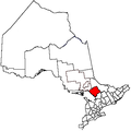
Townships The Archipelago • Armour • Callander • Carling • Joly • Machar • Magnetawan • McDougall • McKellar • McMurrich/Monteith • Nipissing • Perry • Ryerson • Seguin • Strong • WhitestoneVillages Burk's Falls • South River • SundridgeFirst Nations Dokis • French River • Henvey Inlet • Magnetawan • Naiscoutaing • Parry Island • ShawanagaLocal services boards Unorganized areas Centre Part • North East PartSee also: Communities in Parry Sound District • Census divisions of OntarioCategories:- Communities in Parry Sound District, Ontario


Wikimedia Foundation. 2010.