- Deganwy Castle
-
Deganwy Castle Conwy, North Wales 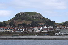
Deganwy Castle with the modern town below it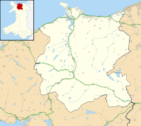
 Deganwy Castle shown within Conwy
Type Castle Coordinates grid reference SH782794 Construction
materialsStone Current
conditionEarthworks remain Deganwy Castle (modern Welsh, Castell Degannwy; also called Caer Ddegannwy in Middle Welsh) was an early stronghold of Gwynedd and lies at the mouth of the River Conwy in Conwy, north Wales. It lies at an elevation of 108 m (354 ft) above sea level.
Details
The Dark Age fortress, which is now little more than ditches and mounds, was formerly made of wood and constructed on a massive rock outcrop in what is now the suburbs of modern Llandudno. Traditionally, it was the headquarters of Maelgwn Gwynedd, King of Gwynedd (fl. c. 520 - 547). A nearby hill is called Bryn Maelgwyn and other places in the locality are associated with him. An important coin hoard of 204 Silver Cnut Pennies were found here in July 1979.
 Ruins and features of the main entrance to Deganwy Castle seen from one of the "towers"
Deganwy was probably first occupied during the Roman period, but was popular in the years following their departure because it was safe from Irish raids. The area beneath the rocky stronghold may have been the site of a settlement of serfs. The stronghold was destroyed when struck by lightning in the year 860.
The castle was rebuilt in stone for King Henry III of England, but was abandoned and finally destroyed by Llywelyn ap Gruffudd, Prince of Wales in 1263. Conwy Castle was later constructed just across the estuary.
When the ruins were excavated by archaeologist Leslie Alcock in the 1960s a dozen sherds of Dark Age pottery which had been imported from the Mediterranean were discovered indicating the far-reaching contacts of Gwynedd's royal dynasty.
See also
- Castles in Great Britain and Ireland
- List of castles in Wales
External links
Categories:- Castles in Conwy county borough
- Hill forts in Wales
- Castle ruins in Wales
- Sub-Roman Britain


Wikimedia Foundation. 2010.