- Cherangani Hills
-
Cherangani Hills, gently rolling slopes in the western highlands of Kenya, are one of Kenya's five main forests. The highlands, the large central plateau, is divided by the Mau Escarpment rising from the border with Tanzania up to the Cherangani Hills, fencing the plateau that rises to the slopes of Mount Elgon.[1]
The Cherangani Hills are not of volcanic origin, unlike most of Kenya’s mountain ranges, although they are located on a forested escarpment with shear cliff walls surrounding them on three sides.[2] Visible are forested ridges and stark, rocky gorges. The Cherangani Hills offer the best hill walking in Kenya for the visitor.[3]
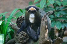 The rare De Brazza's Monkey
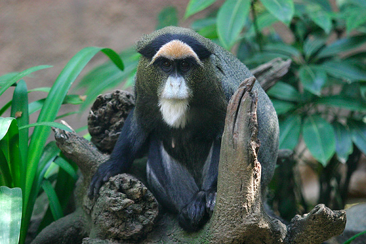
The Cherangani Hills are monitored by the United Nations Environmental Programme as one of the five most important water catchment areas in Kenya.[4] As of the last report, monitoring the change in forestation between 2000 and 2003, the Cherangani Hills were the least affected of the forests monitored, with 174.3 hectares deforested, this loss is occurring within Marakwet District and West Pokot District. Since this forest cover is indigenous, the report recommends that the area be closely watched to prevent further destruction.[5]
The rare De Brazza's Monkey has been sighted here.[6] The monkeys are confined to small areas in the Cherangani Hills that offer them little protection.[7]
Footnotes
- ^ "Kenyalogy: Geography - Rift Valley and Highlands". www.kenyalogy.com. http://www.kenyalogy.com/eng/info/geo.html. Retrieved 2008-03-18.
- ^ "Mountains>Western Highlands". www.magicalkenya.com. http://www.magicalkenya.com/default.nsf/doc21/4YND6YFZEI55?opendocument&l=1&e=3. Retrieved 2008-03-18.
- ^ Joseph Bindloss, Tom Parkinson & Matt Fletcher. "Kenya - Google Book Search". books.google.com. pp. 328. http://books.google.com/books?id=BGeXmssXsGgC&pg=RA1-PA302&lpg=RA1-PA302&dq=Cherangani+Hills&source=web&ots=6T39T8qp3o&sig=A5E3M2J0ZH5RFQ19Xt4RR5msX1M&hl=en#PRA1-PA328,M1. Retrieved 2008-03-18.
- ^ "- Changes in Forest Cover in Kenya's". www.africanconservation.org. http://www.africanconservation.org/dcforum/DCForumID5/244.html. Retrieved 2008-03-18.[dead link]
- ^ "Changes in forest cover in Kenya's five "water towers" 2000 -2003". www.unep.org. http://www.unep.org/dewa/assessments/EcoSystems/land/mountain/Tower/index.asp. Retrieved 2008-03-18.
- ^ Karere G. Mugambi, Thomas M. Butynski, Mbaruk A. Suleman & Wilbur Ottichilo. "SpringerLink - Journal Article". www.springerlink.com. http://www.springerlink.com/content/p18ku34578782545/. Retrieved 2008-03-18.
- ^ Brennan, E. Jean. "Wiley InterScience: Journal: Abstract". www3.interscience.wiley.com. http://www3.interscience.wiley.com/cgi-bin/abstract/110487428/ABSTRACT. Retrieved 2008-03-18.
Categories:- Kenya geography stubs
- Mountain ranges of Kenya
- Great Rift Valley
Wikimedia Foundation. 2010.