- Dee Why, New South Wales
-
For the ferry, see Dee Why ferry.
Dee Why
Sydney, New South Wales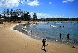
Dee Why BeachPopulation: 17,463[1] Postcode: 2099 Location: 18 km (11 mi) north-east of Sydney CBD LGA: Warringah Council State District: Manly, Wakehurst[2] Federal Division: Warringah,[3] Mackellar[4] Suburbs around Dee Why: Cromer Collaroy Narraweena Dee Why Tasman Sea Brookvale North Curl Curl Dee Why is a suburb of northern Sydney, in the state of New South Wales, Australia. Dee Why is located 18 kilometres north-east of the Sydney central business district and is the administrative centre of the local government area of Warringah Council, and along with Brookvale is considered to be the main centre of the Northern Beaches region.
Contents
History
Name
The origin of the name of neighbouring Long Reef is obvious, but the reasons for Dee Why's name remain unclear. The earliest reference to it is a pencil note in surveyor James Meehan's field book, "Wednesday, 27th Sept, 1815 Dy Beach - Marked a Honey Suckle Tree near the Beach".[5] What it meant to him was not recorded,[6] although various claims have been put forward, including:
- The letters DY were simply a marker that Meehan used to mark many other places on his map.[7]
- The name came from the local Aboriginal language that Meehan used to name many of the locations that he surveyed.[8]
- The name came from the derivative in calculus, dy/dx, in reference to the shape of the curve of the beach as seen on a map.[9]
From 1840 the name was recorded as one word, 'Deewhy', but was split in two during the 1950s. The term 'Dee Why' was also used to name 'Dee Why Heights' or Highlands, known as Narraweena since 1951, and 'Dee Why West', the name of which was changed to Cromer in 1969.[7]
Pre-European history
Little is known of the Aboriginal people who lived in the Dee Why area before European occupation, although there is evidence of a midden at the southern end of Dee Why Beach, and the indigenous people were known to fish on the then wider and deeper lagoon, where black swans were once seen in large flocks.[8]
Early development
The first land in the area to be listed by the New South Wales government Gazette was 700 acres (280 ha) granted to William Cossar in the early 19th century, but by the mid-19th century most of the land in what is now Dee Why had been acquired by James Jenkins and other members of the Jenkins family. Elizabeth Jenkins, eldest daughter of James, gave all her land to the Salvation Army upon her death in 1900, in recognition of their support in her old age. The Salvation Army received in total 1,740 acres (700 ha) of land, 200 acres (81 ha) of which were in Dee Why. An industrial farm, as well as hostels for boys, girls and women were established on this land. Access to the beach was limited by the Salvation Army's land, with a wire netting barrier running along its length.[8]
Warringah Council was formed in 1906, giving Dee Why residents a local government. In 1911 it was decided that the tram line that had expanded in sections from Manly since 1903 was to be extended from Brookvale on to Collaroy Beach via Pittwater Road, and soon after to Narrabeen.[10] The line opened on 3 August 1912 with an hourly service, and it was perhaps this development that caused the Salvation Army in 1913 to progressively sell off most of its holdings on the Northern Beaches, starting with The Oaks Estate Auction, which gave its name to one of the main streets of Dee Why, Oaks Avenue. Another main street, Howard Avenue, commemorates Commissioner Thomas Howard, the first commissioner of the Salvation Army in Australia and New Zealand. By 1920, most of Dee Why had been subdivided.[11] From the end of 1938, the trams, as a result of losses due to low population density and competition with new bus routes that duplicated their services, operated only at peak hours for commuters and on weekends for tourists, and finally ceased operating with the final run on 30 September 1939.[10]
In 1971, work began on a new Dee Why civic centre, inspired by Sulman Prize-winning architects Edwards, Madigan & Torzillo. The building was completed in 1972 and the Council moved there in 1973 from the Shire Hall in Brookvale where meetings had been held since 1912, making Dee Why the seat of Warringah Council.[12]
Geography
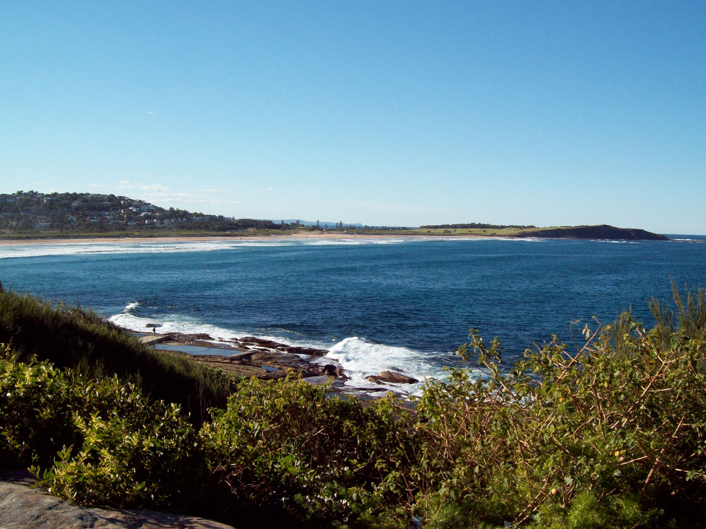
 Dee Why Beach and Long Reef from the Bicentennial Coastal Walkway
Dee Why is contained in the drainage basin of Dee Why Lagoon, and stretches from Victor Road in the west to Dee Why Beach in the east, and from the crest of Wingala Hill to the northern edge of Dee Why Lagoon. The Bicentennial Coastal Walkway from Queenscliff to Palm Beach leads from North Curl Curl Beach in the south, along the cliffs of Dee Why Head and down to the southern end of Dee Why Beach. The track exhibits the coastal heath ecosystem that used to be spread all over the Warringah area, and has been extensively regenerated since 1991.[13]
Another significant natural area within Dee Why is the Stony Range Botanic Garden, established in 1957 on the site of an old quarry and located just south of the Dee Why town centre. The garden, which contains plants from all over Australia as well as those indigenous to the area, has four main sections, the rainforest gully, the sandstone heath on the site of the quarry, the Federation Cascades built in 2001 to commemorate the centenary of the federation of Australia, and the primitive plant section, with examples of plant species that have survived for millions of years. The garden is open from 8am to 5pm every day except Christmas Day, and admission is free.[14]
Dee Why Beach
 Dee Why Beach and Dee Why Lagoon, view from Long Reef
Dee Why Beach runs for about 1.2 km along the eastern border, overlooking the Tasman Sea. To the north are the dunes separating the beach from the Dee Why Lagoon. At its southern end is the Ted Jackson Reserve (renamed from Dee Why Beach Reserve in October 2010),[15] with picnic areas and century old Norfolk Island Pines, similar to the ones in Manly. The reserve is contained by a seawall running for approximately 400m, and was upgraded in 2006, with new pathways, stairs, lookout platforms, an upper promenade and the restoration of the war memorial.[16] There are two playgrounds in the vicinity, located at the southern end of the beach and west of the Dee Why Surf Life Saving Club, near to the lagoon, and several ocean pools located below cliffs to the south. Car parking facilities exist in the streets to the south, as well as a car park next to the Life Saving Club.
 Tank traps dating from World War II in Dee Why Lagoon.
Dee Why Lagoon
Behind the beach's remaining dunes, to the north of The Strand, is Dee Why Lagoon. Its entrance marks the northern end of Dee Why Beach and the southern extent of Long Reef Beach. The high conservation value of the lagoon and its surrounding area was recognised in 1973 when it was proclaimed a wildlife refuge. It is an extremely significant area for local and migratory birds, and is listed on migratory bird agreements with Japan and China. The Dee Why Lagoon Wildlife Refuge covers an area of 77 hectares, of which the lagoon takes up 30 hectares. The rest of the reserve is primarily swamp-based bushland, as well as the coastal dune ecosystem between the lagoon and the sea. It is a major scenic feature of the Northern Beaches, situated off Pittwater Road, and accessible from Dee Why Parade and The Strand.[17]
Commercial areas
 Apartments on the corner of Pittwater Road and Dee Why Parade.
 Shop selling flowers on Fisher Road, in suburban Dee Why.
The main commercial area in Dee Why is centred on either side of Pittwater Road, the main arterial road on the Northern Beaches, and continues down the streets leading to the beach as well as upwards along Fisher Road. This area is characterised by 1960s shop-top, two and three storey buildings and later, four to ten storey developments. The most significant of these later buildings is Dee Why Grand in the south of the main commercial area. Completed in mid 2010, it includes a shopping arcade and the new Dee Why Hotel, as well as two 10 storey residential towers and a significant amount of commercial office space. Also on Pittwater Road is the Warringah Council Chambers and the Dee Why branch of Warringah Library, one of four networked branches of the Library.
The Strand, running along the southern Dee Why beach front, is a major commercial area, and features two to four storey buildings with cafes, restaurants and bars overlooking the beach.
There is also a set of eight mainly single storey shops at the corner of South Creek Road and Pittwater in the northern part of Dee Why, next to the lagoon, as well as a few corner stores scattered in the more suburban areas.
Transport
Public transport in Dee Why primarily runs along Pittwater Road in the form of buses, with services southwards to the City, Manly and North Sydney, and northwards to Collaroy, Cromer, Narrabeen, and the Pittwater area. The main bus stop for these services is located at the intersection with Howard Avenue. There are also semi-regular services to Chatswood via McInstosh Road to the west, as well as to Manly via Freshwater. Two express services to the city also run from near Dee Why Beach in the early morning and back from the city in the afternoon to serve commuters on weekdays.[18]
Sport and recreation
There are many sporting clubs in the area of Dee Why.
One of the well known teams is the Rugby Union side, Dee Why Lions. Dee Why Lions have very well established teams in the game of Rugby ranging from children's teams to the senior team that competes in the NSW Suburban Rugby Union sixth-division Meldrum Cup.
DYFC (Dee Why Football Club)[soccer], also known as "The Swans", was “officially” formed in 1946 making it one of the oldest soccer teams in the peninsular Northern Beaches. It is possible, however, that the team could have a longer history than this. Local historians know of two medals, dating to 1925 and 1926, that were awarded to players for matches undertaken as part of the Dee Why team. According to the club website, amongst the notable events in their history was an exhibition match that took place against Manly Warringah in 1983. Dee Why won the match 2-1 and the winning goal was scored by guest player George Best, a former Manchester United and Northern Ireland national football team member.[19]
Dee Why is also home to the Dee Why Surfing Fraternity, Australia's oldest surfboard riders club, founded in 1961 and still competing each month.[20]
Education
There are two public primary schools in Dee Why, both along Fisher Road: Dee Why Public School (1922) and Fisher Road Special School (1953). St Kevin's Catholic Primary School (1935) lies across Oaks Avenue from the church of the same name.
St Luke's Grammar School (founded 1993 from Roseby Preparatory (Junior) School, Peninsula Grammar (Boys) School and St Luke's Anglican College for Girls), a K – 12 Anglican school, can be found on Headland Road in the south on the western slopes of Wingala Hill.
Religion
At the 2006 census, the main religious affiliations in Dee Why were Roman Catholic (26.4%), No Religion (19.1%), Anglican (18.6%), Eastern Orthodox (4%), Uniting Church (3.4%), and Buddhism (3%).[21]
Churches
Dee Why, being the most populous suburb on the Northern Beaches, is home to churches of many denominations. A Methodist church was built on the corner of Howard Avenue and Avon Road in the 1930s, and is currently the oldest church building in Dee Why. With the rest of the Methodist Church, it joined the Uniting Church at its founding in 1977. It is currently home to the Cecil Gribble Congregation, a Tongan congregation of the Uniting Church. St John's Anglican Church was established in 1922. The current church, constructed in 1957 on the corner of Oaks Avenue and Avon Road, is well known for its modern stained glass artwork, installed over a period of years, including the recent addition of the Missions to Seamen Window in the new chapel, from the old MTS Chapel in The Rocks.[22] St Kevin's Catholic Church was established in 1923 on Oaks Avenue.[23] The current building, built in 1962, has a very distinctive design mimicking the structure of a tent. The Dee Why Baptist Church (1940) was renamed the New Life Baptist Church in 2000.[24] St David's Uniting Church, the spire of which can be seen from a long way on Pittwater Road in both directions, was built in the 1940s as a Presbyterian church, joining the Uniting Church with two-thirds of the Presbyterians in 1977. The short section of road from Pittwater Road to Fisher Road was formerly known as part of Howard Avenue, but was renamed in the late 1990s to St David Avenue. The Salvation Army still maintains a presence in Dee Why, with a church located on Fisher Road, and there is a Jehovah's Witness Kingdom Hall further north on Pittwater Road.
- Churches
-

The oldest church in Dee Why, currently the Cecil Gribble Congreation, of the Uniting Church.
-

St John's Anglican Church.
-

St Kevin's Catholic Church, with its distinctive tent-like architecture.
-

Dee Why Baptist Church.
-

St David's Uniting Church.
Mosque
Dee Why is also home to the only mosque on the Northern Beaches. It is located on South Creek Road, just north of the shops at the corner of Pittwater Road and South Creek Road.
Governance
Dee Why is within the Warringah Council Local Government Area, and is home to the Warringah Council Civic Centre built in 1973, which contains the Council Chambers and is situated just to the north of the Sulman Award-winning Library, completed in 1966. Parts of the suburb lie in the A and B Wards of the Council.
Dee Why is in both the federal electorates of Warringah, represented by Tony Abbott leader of the Liberal Party and the current opposition leader, and the electorate of Mackellar, which is currently represented by Bronwyn Bishop, also of the Liberal Party. The suburb lies within both the state electorates of Wakehurst and Manly, who are represented by the Liberal Party members Brad Hazzard, the Planning Minister, and Mike Baird, the State Treasurer, respectively.
References
- ^ Australian Bureau of Statistics (25 October 2007). "Dee Why (State Suburb)". 2006 Census QuickStats. http://www.censusdata.abs.gov.au/ABSNavigation/prenav/LocationSearch?collection=Census&period=2006&areacode=SSC11291&producttype=QuickStats&breadcrumb=PL&action=401. Retrieved 13 February 2008.
- ^ "State Electoral Office search results". NSW State Electoral Office. http://www.elections.nsw.gov.au/redistribution_2004/district_search?queries_locality_query=Dee+Why. Retrieved 10 December 2006.
- ^ "Division of Warringah". Australian Electoral Commission. http://www.aec.gov.au/profiles/nsw/warringah.htm. Retrieved 16 November 2010.
- ^ "Division of Mackellar". Australian Electoral Commission. http://www.aec.gov.au/profiles/nsw/mackellar.htm. Retrieved 16 November 2010.
- ^ Messent, David (1999). Sydney's Northern Beaches. David Messent Photography. ISBN 0-9577124-05.
- ^ Pollen, Frances (ed.) (1990). The Book of Sydney Suburbs. Australia: Angus & Robertson Publishers. p. 82. ISBN 0-207-14495-8.
- ^ a b Boyce, Jim (2006). Pictorial History: Warringah. Alexandria, New South Wales: Kingsclear Books. p. 130. ISBN 0-908272-85-5.
- ^ a b c Boyce, Jim (2006). Pictorial History: Warringah. Alexandria, New South Wales: Kingsclear Books. p. 63. ISBN 0-908272-85-5.
- ^ Pender, Bill (1999). Cambridge Mathematics Year 11 3 unit. Port Melbourne, Victoria: Cambridge University Press. p. 250. ISBN 0-521-65864-0.
- ^ a b "Brief Background History of Tramways in Manly". Manlymania. January 2011. Archived from the original on 11 June 2011. http://www.webcitation.org/5zMGhvnIp. Retrieved 11 June 2011.
- ^ Boyce, Jim (2006). Pictorial History: Warringah. Alexandria, New South Wales: Kingsclear Books. p. 7. ISBN 0-908272-85-5.
- ^ "Centenary of Warringah". Warringah Council. 31 March 2009. http://www.warringah.nsw.gov.au/council_now/centenary.aspx. Retrieved 11 June 2011.
- ^ "Dee Why Headland/Escarpment". Warringah Online. Warringah Council. 20 December 2007. http://www.warringah.nsw.gov.au/environment/DeeWhyHeadlandEscarpment.aspx. Retrieved 11 November 2008.
- ^ "Stony Range Botanic Garden". Warringah Online. Warringah Council. 16 September 2008. http://www.warringah.nsw.gov.au/environment/StonyRangeBotanicGarden.aspx. Retrieved 11 November 2008.
- ^ "Ted Jackson is remembered" (PDF). Media Release. Warringah Council. 19 October 2010. http://www.warringah.nsw.gov.au/news_events/documents/MediaReleaseTedJacksonReserve.pdf. Retrieved 16 November 2010.
- ^ "RESERVE THE STRAND DEE WHY - CONSTRUCTION OF TIMBER DECK, NEW PAVED PROMENADE AND ASSOCIATED LANDSCAPE WORKS" (PDF). Report to Independent Hearing & Assessment Panel Meeting on 12 April 2006. Warringah Council. 13 December 2006. http://www.warringah.nsw.gov.au/council_then/documents/IHAP_2006041232.pdf. Retrieved 16 November 2010.
- ^ "Dee Why Lagoon Wildlife Reserve". Warringah Online. Warringah Council. 21 December 2007. http://www.warringah.nsw.gov.au/environment/DeeWhyLagoonWildlifeRefuge.aspx. Retrieved 11 November 2008.
- ^ "Northern Region Guide Map" (PDF). Sydney Buses. NSW Government. http://www.sydneybuses.info/uploads/file/pdfs/network-maps/northern-region-map.pdf. Retrieved 16 November 2010.
- ^ "Dee Why Football Club : History". Dee Why Football Club. http://dyfc.com.au/about/history. Retrieved 12 September 2011.
- ^ "Dee Why Surfing Fraternity History". Dee Why Surfing Fraternity. 26 December 2008. http://dysf.info/history1.html. Retrieved 29 August 2010.
- ^ "20680-Religious Affiliation (narrow groups) by Sex - Dee Why" (Excel). Australian Bureau of Statistics. Commonwealth of Australia. 27 June 2007. http://www.censusdata.abs.gov.au/ABSNavigation/download?format=xls&collection=Census&period=2006&productlabel=Religious%20Affiliation%20(narrow%20groups)%20by%20Sex&producttype=Census%20Tables&method=Place%20of%20Usual%20Residence&areacode=SSC11291. Retrieved 16 November 2010.
- ^ "Resources – History". St Johns Anglican Church. http://www.stjohnsdeewhy.org.au/r_history.html. Retrieved 31 August 2010.
- ^ "St Kevin". St Kevins Catholic Church. http://www.stkevinsdy.org.au/ChurchHTML/profile.htm. Retrieved 31 August 2010.
- ^ "New Life". New Life Baptist Church. http://www.nl.org.au/about.html. Retrieved 31 August 2010.
External links
- Dee Why, New South Wales is at coordinates 33°45′16″S 151°17′07″E / 33.75444°S 151.28538°ECoordinates: 33°45′16″S 151°17′07″E / 33.75444°S 151.28538°E
- Warringah Council website
Suburbs of Warringah Council | Northern Beaches | Sydney Allambie Heights · Beacon Hill · Belrose · Brookvale · Collaroy · Collaroy Plateau · Cottage Point · Cromer · Curl Curl · Davidson · Dee Why · Duffys Forest · Forestville · Frenchs Forest · Freshwater · Ingleside · Killarney Heights · Manly Vale · Narrabeen · Narraweena · North Balgowlah · North Curl Curl · North Manly · Oxford Falls · Queenscliff · Terrey Hills · Wheeler HeightsList of Sydney suburbs Categories:- Suburbs of Sydney
- Beaches of New South Wales


Wikimedia Foundation. 2010.