- Nolin River Lake
-
Nolin River Lake 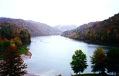
Location Edmonson / Grayson / Hart counties, Kentucky, USA Coordinates 37°18′40.81″N 86°14′15.09″W / 37.3113361°N 86.237525°WCoordinates: 37°18′40.81″N 86°14′15.09″W / 37.3113361°N 86.237525°W Lake type reservoir Primary inflows Nolin River Primary outflows Nolin River Basin countries United States Nolin River Lake is a reservoir in Edmonson, Grayson, and Hart counties in Kentucky. It was impounded from the Nolin River by the United States Army Corps of Engineers in 1963.[1] The Nolin River dam was authorized in 1938 as part of a flood control act. The lake varies from 2,890 acres (11.7 km²) in the winter to 5,795 acres (23.5 km²) in the summer.
Nearby attractions include Mammoth Cave National Park, Nolin Lake State Park, Moutardier Resort and Marina, and Wax Marina.
References
- ^ Kleber, John E., ed (1992). "Lakes". The Kentucky Encyclopedia. Associate editors: Thomas D. Clark, Lowell H. Harrison, and James C. Klotter. Lexington, Kentucky: The University Press of Kentucky. ISBN 0-8131-1772-0.
External links
- US Army Corps of Engineers page on Nolin Lake
- Nolin Lake State Park facilities map
- Nolin Lake Sate Park interactive GIS map
Lakes and reservoirs of Kentucky Lake Barkley · Barren River Lake · Beaver Lake · Boltz Lake · Buckhorn Lake · Bullock Pen Lake · Lake Beshear · Cannon Creek Lake · Lake Carnico · Carr Creek Lake · Cave Run Lake · Cedar Creek Lake · Cranks Creek Lake · Lake Cumberland · Dale Hollow Lake · Dewey Lake · Doe Run Lake · Elk Lake · Elmer Davis Lake · Fishtrap Lake · Grayson Lake · Green River Lake · Greenbo Lake · Guist Creek Lake · Herrington Lake · Kentucky Lake · Kincaid Lake · Laurel River Lake · Lake Linville · Lake Malone · Martins Fork Lake · Nolin River Lake · Paintsville Lake · Pan Bowl Lake · Rough River Lake · Shanty Hollow Lake · Shelby Lake · Swan Lake · Taylorsville Lake · Wilgreen Lake · Williamstown Lake · Willisburg Lake · Wood Creek Lake · Yatesville Lake
 Categories:
- 1963 establishments
- Geography of Edmonson County, Kentucky
- Geography of Grayson County, Kentucky
- Geography of Hart County, Kentucky
- Reservoirs in Kentucky
- Buildings and structures in Edmonson County, Kentucky
- Buildings and structures in Grayson County, Kentucky
- Buildings and structures in Hart County, Kentucky
- Kentucky geography stubs


Wikimedia Foundation. 2010.