- Crab Orchard, Tennessee
-
Crab Orchard, Tennessee — City — Crab Orchard, with Big Rock Mountain in the background Location of Crab Orchard, Tennessee
Coordinates: 35°54′21″N 84°52′38″W / 35.90583°N 84.87722°WCoordinates: 35°54′21″N 84°52′38″W / 35.90583°N 84.87722°W Country United States State Tennessee County Cumberland Government – Mayor Jane Lingersol Area – Total 11.1 sq mi (28.8 km2) – Land 11.1 sq mi (28.8 km2) – Water 0.0 sq mi (0.0 km2) Elevation 1,677 ft (511 m) Population (2000) – Total 838 – Density 75.5/sq mi (29.1/km2) Time zone Central (CST) (UTC-6) – Summer (DST) CDT (UTC-5) ZIP code 37723 Area code(s) 931 FIPS code 47-17840[1] GNIS feature ID 1281520[2] Crab Orchard is a city in Cumberland County, Tennessee, United States. The population was 838 at the 2000 census.
Contents
Geography
Crab Orchard is located at 35°54′21″N 84°52′38″W / 35.905965°N 84.877239°W (35.905965, -84.877239).[3] The town is situated atop the Cumberland Plateau in a gap amidst the Crab Orchard Mountains, a sub-range of the Cumberland Mountains. This gap has long been frequented by travelers between East and Middle Tennessee. Today, both Interstate 40 and U.S. Route 70 pass through Crab Orchard.
Big Rock Mountain (el. 2,703 ft/824m) rises prominently to the north of Crab Orchard. Haley Mountain (el. 2,660 ft/811m) and Black Mountain (2,827 ft/861m) dominate the view to the south. A section of the Cumberland Trail will, when completed, traverse Crab Orchard from north to south.
According to the United States Census Bureau, the city has a total area of 11.1 square miles (29 km2), all land.
Demographics
As of the census[1] of 2000, there were 838 people, 345 households, and 245 families residing in the city. The population density was 75.5 people per square mile (29.1/km2). There were 448 housing units at an average density of 40.4 per square mile (15.6/km2). The racial makeup of the city was 99.40% White, 0.12% Native American, and 0.48% from two or more races. Hispanic or Latino of any race were 0.36% of the population.
There were 345 households out of which 31.0% had children under the age of 18 living with them, 59.4% were married couples living together, 8.1% had a female householder with no husband present, and 28.7% were non-families. 26.4% of all households were made up of individuals and 9.3% had someone living alone who was 65 years of age or older. The average household size was 2.43 and the average family size was 2.93.
In the city the population was spread out with 23.3% under the age of 18, 7.5% from 18 to 24, 31.0% from 25 to 44, 25.1% from 45 to 64, and 13.1% who were 65 years of age or older. The median age was 38 years. For every 100 females there were 98.1 males. For every 100 females age 18 and over, there were 102.2 males.
The median income for a household in the city was $22,986, and the median income for a family was $29,833. Males had a median income of $24,135 versus $15,809 for females. The per capita income for the city was $11,161. About 12.7% of families and 14.3% of the population were below the poverty line, including 18.1% of those under age 18 and 4.5% of those age 65 or over.
History
Crab Orchard's position in a gap in the Crab Orchard Mountains made it an early "gateway" to the Cumberland area as early as the late 18th century. Pioneers passing through the area named it for its abundance of wild crab apple trees.[4] In the 1780s, a road was built through the gap to help provide protection for travelers migrating from East Tennessee to the Nashville area.[5] The historian J.G.M. Ramsey reported several Cherokee, Creek, and Shawano attacks at "the Crab-Orchard" during a period of heightened tensions between Native Americans and encroaching Euro-American settlers in the early 1790s. Around 1792, a small band of troops led by Captain Samuel Handley was attacked by a mixed group of Cherokee, Creek, and Shawano at Crab Orchard, ending in Handley's capture.[6] In April of 1794, a group of travelers was ambushed by a band of Creeks, killing early Cumberland County settler Thomas "Big Foot" Spencer. A few weeks later, a "Lieutenant McClelland" was attacked and routed by a band of Creeks at Crab Orchard.[7][8]
In the late 18th century, as Cherokee attacks subsided, the Walton Road was built as part of the stage road system connecting the Knoxville and Nashville areas. The road passed through Crab Orchard, bringing a steady stream of travelers and migrants to the area. Around 1800, Sidnor's Inn opened at Crab Orchard, with Bishop Francis Asbury being among its earliest guests. In 1827, Robert Burke, whose wife operated a tavern at what is now Ozone established the Crab Orchard Inn, which would remain open until the early 20th century.[9]
Although one of the oldest communities in the Cumberland area, Crab Orchard was not officially incorporated until 1973.[10]
Stone quarries and mines
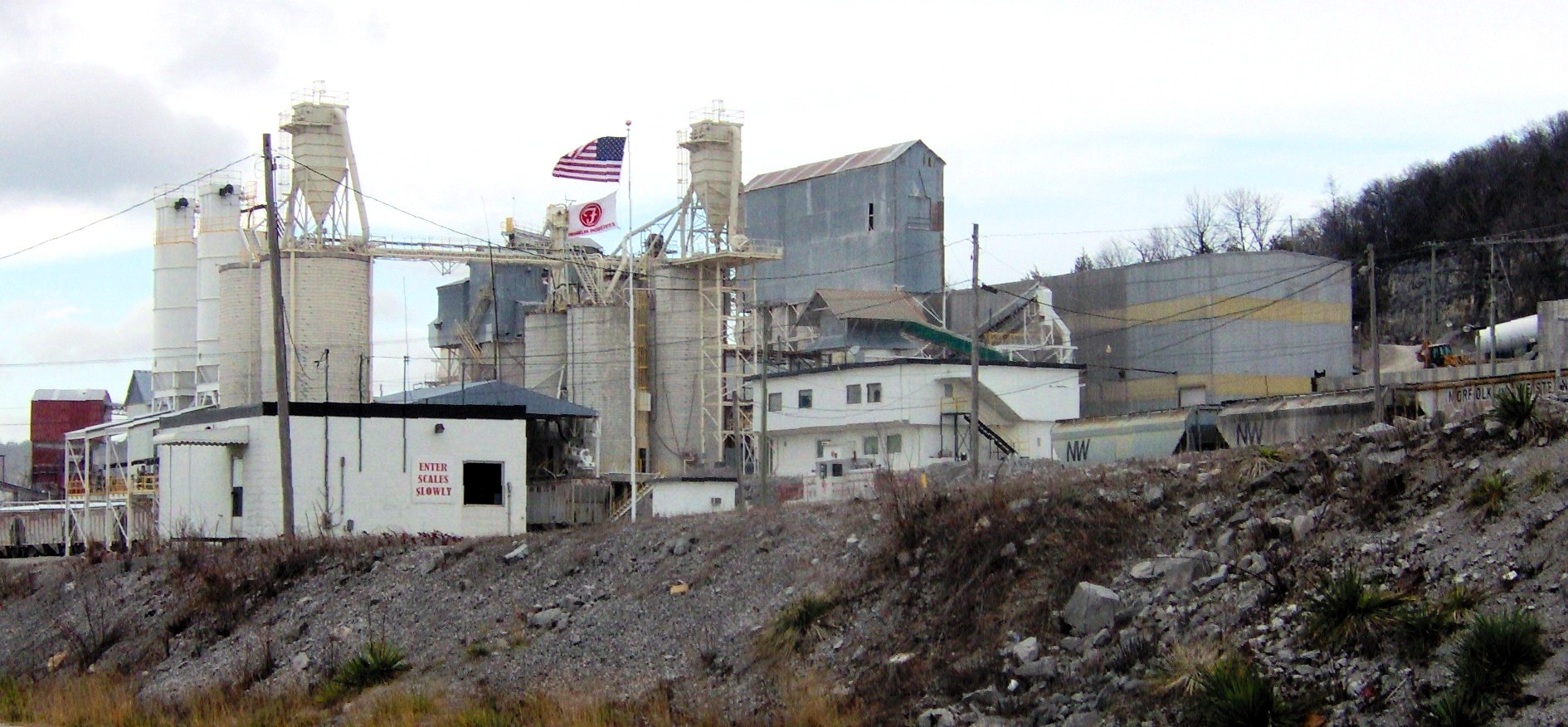
 Franklin Industrial Minerals mine and plant in Crab Orchard
Crab Orchard has given its name to a rare type of durable sandstone found in its vicinity. First used in local structures and sidewalks in the late 19th century, the Crab Orchard stone gained popularity in the 1920s when it was used in the construction of Scarritt College in Nashville. Numerous buildings in Crossville, including the Cumberland County Courthouse, have been constructed with Crab Orchard stone.[11]
Crab Orchard is also home to a large limestone mine operated by Franklin Industrial Minerals. The mine and its accompanying plant dominate the south side of the Crab Orchard gap along Interstate 40 and US-70.
References
- ^ a b "American FactFinder". United States Census Bureau. http://factfinder.census.gov. Retrieved 2008-01-31.
- ^ "US Board on Geographic Names". United States Geological Survey. 2007-10-25. http://geonames.usgs.gov. Retrieved 2008-01-31.
- ^ "US Gazetteer files: 2010, 2000, and 1990". United States Census Bureau. 2011-02-12. http://www.census.gov/geo/www/gazetteer/gazette.html. Retrieved 2011-04-23.
- ^ Helen Bullard and Joseph Krechniak, Cumberland County's First Hundred Years (Crossville, Tenn.: Centennial Committee, 1956), 122.
- ^ J.G.M. Ramsey, The Annals of Tennessee (Johnson City, Tennessee: Tennessee Overmountain Press, 1999), 500-501.
- ^ Ramsey, Annals of Tennessee, 571-572.
- ^ Ramsey, The Annals of Tennessee, 591-595.
- ^ Michael Boniol, "Cumberland County History," 2003. Retrieved: 2 January 2008.
- ^ Bullard and Krechniak, Cumberland County's First Hundred Years, 21, 122.
- ^ The WPA Guide to Tennessee (Knoxville: University of Tennessee Press, 1986), 441. Originally compiled by the Federal Writers' Project of the Works Project Administration as Tennessee: A Guide to the State, and published in 1939.
- ^ Carroll Van West, "Crab Orchard Stone." The Tennessee Encyclopedia of History and Culture, 2002. Retrieved: 2 January 2008.
Municipalities and communities of Cumberland County, Tennessee Cities Crab Orchard | Crossville

Town Unincorporated
communitiesCategories:- Cities in Tennessee
- Populated places in Cumberland County, Tennessee


Wikimedia Foundation. 2010.