- Elizabethton, Tennessee
-
Elizabethton, Tennessee — City — Downtown Elizabethton, July 4th parade (2008).
Nickname(s): The City of Power Map spot for Elizabethton, Tennessee.
Coordinates: 36°20′11″N 82°14′21″W / 36.33639°N 82.23917°WCoordinates: 36°20′11″N 82°14′21″W / 36.33639°N 82.23917°W Country United States State Tennessee County Carter Explored: 1759 Settled: 1769 Established: 1799 Government – Type Council Manager – Mayor Curt Alexander – Mayor Pro Tem Samuel Shipley – City Manager Fred R. Edens Jr. Area – Total 9.4 sq mi (24.3 km2) – Land 9.2 sq mi (23.7 km2) – Water 0.2 sq mi (0.6 km2) Elevation 1,593 ft (465 m) Population (2010) – Total 14,176 – Density 1,459.5/sq mi (563.5/km2) Time zone EST (UTC-5) – Summer (DST) EDT (UTC-4) ZIP codes 37643-37644 Area code(s) 423 FIPS code 47-23500[1] GNIS feature ID 1328127[2] Website http://www.elizabethton.org Elizabethton is the county seat of Carter County, Tennessee, United States.[3] Elizabethton is also the historical site both of the first independent American government (known as the Watauga Association, created in 1772) located west of both the Eastern Continental Divide and the original thirteen British American colonies.
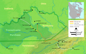
Elizabethton is also the historical site of the Transylvania Purchase (1775), a major historic muster site during the American Revolutionary War for both the Battle of Musgrove Mill (1780) and the Battle of Kings Mountain (1780), and a local community within the secessionist North Carolina "State of Franklin" territory (1784–1788).
The population of Elizabethton was enumerated at 14,176 during the 2010 U.S. Decennial Census.[4]
Geography
Northeast Tennessee location
Elizabethton is centrally located within the "Tri-Cities" area (encompassed by Bristol, Johnson City, and Kingsport) of Northeast Tennessee.[5][6]
Time offset from Coordinated Universal Time (UTC): UTC-5 (Eastern Standard Time).
According to the United States Census Bureau, the city has a total area of 9.4 square miles (24.3 km), of which, 9.2 square miles (23.7 km) of it is land and 0.2 square miles (0.6 km) of it (2.35%) is water.[7]
The elevation at Elizabethton Municipal Airport is 1,593 feet (486 m) ASL (the highest point of elevation in Carter County is at Roan Mountain with an elevation of 6,285 feet (1,916 m) ASL) and the airport is located on the eastern side of the city along State Highway 91 Stoney Creek Exit.[8][9] Elizabethton is also connected to larger commercial, shuttle, and cargo flights out of Tri-Cities Regional Airport located adjacent to the main campus of Northeast State Technical Community College at nearby Blountville, Tennessee.
Lynn Mountain reaches 2,380 feet (730 m) ASL at the summit (36.350°N, 82.191°W) and is located directly across the U.S. Highway 19-E from the downtown Elizabethton business district.
Elizabethton also shares a contiguous western border with Johnson City.
Climate
Climate data for Bristol-Tri Cities reporting area Month Jan Feb Mar Apr May Jun Jul Aug Sep Oct Nov Dec Year Record high °F (°C) 79
(26)80
(27)85
(29)89
(32)92
(33)97
(36)102
(39)101
(38)98
(37)90
(32)81
(27)78
(26)102
(39)Average high °F (°C) 44.1
(6.7)48.9
(9.4)58.4
(14.7)67.1
(19.5)74.9
(23.8)81.8
(27.7)84.8
(29.3)83.9
(28.8)78.5
(25.8)68.2
(20.1)57.4
(14.1)47.8
(8.8)66.3 Daily mean °F (°C) 34.2
(1.2)38.0
(3.3)46.5
(8.1)54.6
(12.6)63.0
(17.2)70.7
(21.5)74.2
(23.4)72.8
(22.7)66.6
(19.2)55.0
(12.8)45.5
(7.5)37.3
(2.9)54.9 Average low °F (°C) 24.3
(−4.3)27.0
(−2.8)34.6
(1.4)42.0
(5.6)51.0
(10.6)59.5
(15.3)63.5
(17.5)61.7
(16.5)54.7
(12.6)41.8
(5.4)33.6
(0.9)26.8
(−2.9)43.4 Record low °F (°C) −21
(−29)−15
(−26)−2
(−19)21
(−6)30
(−1)38
(3)48
(9)43
(6)34
(1)20
(−7)5
(−15)−9
(−23)−21
(−29)Precipitation inches (mm) 3.52
(89.4)3.40
(86.4)3.91
(99.3)3.23
(82)4.32
(109.7)3.89
(98.8)4.21
(106.9)3.00
(76.2)3.08
(78.2)2.30
(58.4)3.08
(78.2)3.39
(86.1)41.33
(1,049.8)Snowfall inches (cm) 5.6
(14.2)4.1
(10.4)1.9
(4.8)0.9
(2.3)0
(0)0
(0)0
(0)0
(0)0
(0)0.1
(0.3)0.3
(0.8)2.2
(5.6)15.1
(38.4)% humidity 59.0 71.5 69.0 67.0 69.5 73.0 75.0 76.5 76.5 74.0 68.5 69.5 74.0 Avg. precipitation days (≥ 0.01 in) 13.3 11.9 13.0 11.3 12.3 11.9 11.5 10.0 8.8 8.4 10.2 12.0 134.6 Avg. snowy days (≥ 0.1 in) 4.6 3.1 1.5 0.3 0 0 0 0 0 0.1 0.4 2.2 12.2 Source no. 1: NOAA[10] Source no. 2: Climate-zone.com (humidity)[11] Demographics
 Built in 1882, the Elizabethton Covered Bridge(spans 134 feet (41 m) across the Doe River.
As of the census of 2000,[12] there were 13,372 people, 5,454 households, and 3,512 families residing in the city. The population density was 1,459.3 people per square mile (563.6/km²). There were 5,964 housing units at an average density of 650.9 per square mile (251.4/km²). The racial makeup of the city was 95.30% White, 2.47% African American, 0.16% Native American, 0.55% Asian, 0.01% Pacific Islander, 0.49% from other races, and 1.02% from two or more races. Hispanic or Latino of any race were 1.18% of the population.
There were 5,454 households out of which 26.6% had children under the age of 18 living with them, 46.6% were married couples living together, 14.7% had a female householder with no husband present, and 35.6% were non-families. 32.6% of all households were made up of individuals and 16.5% had someone living alone who was 65 years of age or older. The average household size was 2.24 and the average family size was 2.82.
In the city the population was spread out with 20.5% under the age of 18, 10.8% from 18 to 24, 24.5% from 25 to 44, 23.1% from 45 to 64, and 21.0% who were 65 years of age or older. The median age was 40 years. For every 100 females there were 82.3 males. For every 100 females age 18 and over, there were 76.8 males.
The median income for a household in the city was $25,909, and the median income for a family was $33,333. Males had a median income of $26,890 versus $20,190 for females. The per capita income for the city was $14,578. About 15.2% of families and 19.4% of the population were below the poverty line, including 29.8% of those under age 18 and 16.1% of those age 65 or over.
Water Resources and Renewable Energy
Doe River
 "The City of Power" electric sign that was erected over the old Elk Avenue Bridge (circa 1912-1913).
The Doe River forms in Carter County, Tennessee near the North Carolina line, just south of Roan Mountain State Park. The river initially flows north and is first paralleled by State Route 143; at the community of Roan Mountain, Tennessee, it then continues to flow west and is at this point paralleled by U.S. Route 19E. The Doe River flows to the east of Fork Mountain; the Little Doe River flows by the Fork Mountain to the west.
Below the confluence of both the Doe River and the Little Doe River at Hampton, the Doe River then travels roughly in a northern downstream direction through the Valley Forge community, and is rejoined by U.S. Route 19E. Pushing through a mountain gap just north of Hampton, the volume of the river is amplified by the waters flowing from McCathern Spring.
 Broad Street Bridge .
Further downstream, the Doe River flows by the East Side neighborhood and parallel with Tennessee State Route 67 and then underneath the historic Elizabethton Covered Bridge, built in 1882 and located within the Elizabethton downtown business district. Connecting 3rd Street and Hattie Avenue, the covered bridge is adjacent to a city park and spans the Doe River. The covered bridge, although now closed to motor traffic, is still open for bicycles and pedestrians.
Most of Elizabethton's downtown is listed on the National Register of Historic Places for its historical and architectural merits. The Elizabethton Historic District contains a variety of properties ranging in age from the late 18th century through the 1930s. However, the Elizabethton Covered Bridge is an important focal point and a well-known landmark in the state. In addition to the Covered Bridge, the downtown historical district also contains the 1928 Elk Avenue concrete arch bridge, and just a little further downstream on the Doe River, Tennessee State Route 67 passes another similar concrete arch bridge locally known as the Broad Street Bridge.
Elizabethton celebrates in the downtown business area for one week each June with the Elizabethton Covered Bridge Days featuring country and gospel music performances, activities for children, Elk Avenue car club show, and many food and crafts vendors.
Watauga River
 Raft guide plunging whitewater rafters downstream through "The Big Hole" in the Bee Cliff Rapids
Two Tennessee Valley Authority reservoirs in Carter County — impounded behind both the TVA Watauga Dam (itself forming the TVA Watauga Reservoir)[13] and the immediately downstream TVA Wilbur Reservoir[14] — are located southeast and upstream of Elizabethton on the Watauga River. The Appalachian Trail crosses over both the Watauga River and the Tennessee Valley Authority reservation in Carter County to the southeast of Elizabethton.[15][16]
The Watauga River flows past Elizabethton. Elizabethton lies on the south bank of the Watauga and along either side of its principal tributary, the Doe River. The downtown business district is located approximately one-quarter mile upstream of the confluence of both the Doe River and the Watauga River. The Doe River flows underneath the historic wooden covered bridge that is located within the Elizabethton downtown business district.
The city of Elizabethton was at one time promoted as "The City of Power" as the town is located just southeast of the Wilbur Dam hydrogeneration site spanning the Watauga River. Construction of Wilbur Dam first began during 1909 and two hydroelectric generating units were online with power production at Wilbur Dam when it was completed in 1912.[14] A third generating unit was added to Wilbur Dam in 1926, and a fourth hydrogeneration unit was added to Wilbur Dam after the Tennessee Valley Authority acquired the power production facility in 1945.[14]
The Bee Cliff Rapids — a popular summer destination on the Watauga River for whitewater rafters during the summer months — are located southeast of Elizabethton and downstream of the TVA Wilbur Dam.
The Watauga River downstream of the western side of Elizabethton has one of the only two sections of trophy trout streams across the entire state of Tennessee.
Holston Mountain Communication Towers
 The main waterfall at Blue Hole Falls located northeast of Elizabethton on Holston Mountain.
Elizabethton itself lies within a river valley basin mostly surrounded by mountain ridges and significant hills, such as Holston Mountain, the southern end of which lies just northeast of Elizabethton. Panhandle Road is located off State Highway 91 in Carter County and ascends Holston Mountain for three miles (5 km) from the eastern side and ends four miles (6.5 km) along the ridge southwest of Holston High Point. During periods of heavy snow and ice, the National Forest Service closes off Panhandle Road with an iron gate.
Located near the Cherokee National Forest boundary and to the left of Panhandle Road is a parking area and foot trail that leads down the slope to the Blue Hole Falls (approximately 45 feet (14 m) high). The last three miles (5 km) of Panhandle Road are filled with washouts, steep drop-offs, and no turnarounds. Vehicle travel on those last three miles (5 km) is at the driver's risk.
 Holston High Point as seen from Holston High Knob.
Early broadcasters in the 1950s and 1960s quickly realized Holston Mountain would be a prime radio-television transmission location because it is the highest visible point that faces most of the major cities in Northeast Tennessee in the surrounding valley between Knoxville, Tennessee, to southwest of Roanoke, Virginia. As a result, the Holston Mountain ridge is the transmitter site for three television stations in the Tri-Cities, Tennessee Television Designated Market Area (DMA). The broadcasting antenna for WCYB-TV, Channel 5, Bristol, Virginia is on Rye Patch Knob, with the top of the antenna 341 feet (104 m) above ground, 2,431 feet (741 m) above the surrounding valley floor, and 4,533 feet (1381.6 m) above mean sea level. The single tower that antenna sits on, is the highest and tallest man-made structure on the mountain. The television towers for WJHL-TV, Channel 11, Johnson City, Tennessee, and WKPT-TV, Channel 19, Kingsport, Tennessee, are standing side by side in a common broadcasting antenna farm on the southwest slope of Holston High Point, one mile (1.5 km) southwest of Rye Patch Knob. The antenna for WJHL-TV stands 200 feet (61m) above ground, 2,319 feet (707m) above the surrounding valley floor, and 4,370 feet (1,332m) above mean sea level. The antenna for WKPT-TV next door stands 193 feet (58.8m) above ground, also 2,319 feet (707m) above the valley floor, and 4,366 feet (1,331m) above mean sea level. The stations' digital antennas are also on their respective towers.
Holston Mountain is also the transmitting site for three FM Class C radio stations: WTFM-FM 98.5, Kingsport, Tennessee; WXBQ-FM 96.9, Bristol, Virginia and WETS-FM 89.5, Johnson City, Tennessee. All three antennas and the backup antennas are located at the antenna farm on the southwest slope of Holston High Point. Also located on the ridge are the antenna for one FM Class C1 radio station, WHCB-FM 91.5, Bristol, Tennessee, located at Rye Patch Knob; one FM Class C2 antenna for radio station WCQR-FM 88.3, Kingsport, Tennessee, and one FM Class D antenna for radio station W214AP-FM 90.7, Johnson City, Tennessee, both transmitting from the antenna farm on the southwest slope of Holston High Point. Various U.S. federal, Tennessee state, Sullivan, Washington and Carter County governmental agencies, along with utility microwave relay stations, also transmit base-to-mobile communications from the Holston High Point antenna farm and Rye Patch Knob.
The Federal Aviation Administration also maintains a navigational beacon at the Holston Mountain summit.
Connection with U.S. Interstate Highway System


 Interstate 26 Exit 24 at Johnson City then east

 Tennessee State Route 67 to Elizabethton.
History
Native American inhabitants
 A proposed route for the de Soto Expedition, based on Charles M. Hudson map of 1997.
The area now known as Tennessee was first settled by Paleo-Indians nearly 11,000 years ago. The names of the cultural groups that inhabited the area between first settlement and the time of European contact are unknown, but several distinct cultural phases have been named by archaeologists, including Archaic, Woodland, and Mississippian whose chiefdoms were the cultural predecessors of the Muscogee people who inhabited the Tennessee River Valley prior to Cherokee migration into the river's headwaters.
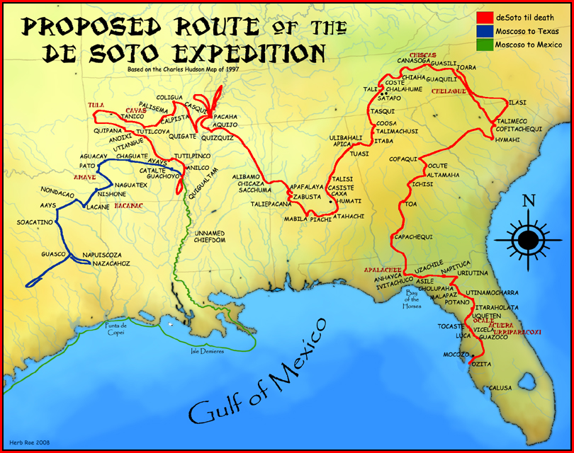
When Spanish explorers first visited Tennessee, led by Hernando de Soto in 1539–43, it was inhabited by tribes of Muscogee and Yuchi people. Possibly because of European diseases devastating the Native tribes, which would have left a population vacuum, and also from expanding European settlement in the north, the Cherokee moved south from the area now called Virginia. As European colonists spread into the area, the native populations were forcibly displaced to the south and west, including all Muscogee and Yuchi peoples, the Chickasaw, and Choctaw. From 1838 to 1839, nearly 17,000 Cherokees were forced to march from "emigration depots" in Eastern Tennessee, such as Fort Cass, to Indian Territory west of Arkansas. This came to be known as the Trail of Tears, as an estimated 4,000 Cherokees died along the way.[17]
Colonial settlement
In 1759, a young James Robertson accompanied explorer Daniel Boone on his third expedition to lands beyond the Alleghany Mountains. The party discovered the "Old Fields" (lands previously cultivated by generations of Native Americans) along the Watauga River valley at present day Elizabethton, in which Robertson planted with corn while Boone continued on to Kentucky. By 1769 Daniel Boone had formed an association with North Carolina promoter and judge Richard Henderson with a goal to purchase and settle a vast tract of Cherokee lands in present day Middle Tennessee and Kentucky, and Boone later relocated his family to the Watuaga Settlement sometime during the Spring of 1771.[18]
James Robertson later returned to North Carolina, and there married Charlotte Reeves in 1767. After the Battle of Alamance in 1771, many North Carolinians refused to take the new oath of allegiance to the Royal Crown and withdrew from the province. Instead of taking their new oath of allegiance, James Robertson led a group of some twelve or thirteen families involved with the Regulator movement from near where present day Raleigh, North Carolina now stands. In 1772, Robertson and the pioneers who had settled in Northeast Tennessee (along the Watauga River, the Doe River, the Holston River, and the Nolichucky River met at Sycamore Shoals to establish an independent regional government known as the Watauga Association.[19]
However, in 1772, surveyors placed the land officially within the domain of the Cherokee tribe, who required negotiation of a lease with the settlers. Tragedy struck as the lease was being celebrated, when a Cherokee warrior was murdered by a white man. Robertson's skillful diplomacy made peace with the irate Native Americans, who threatened to expel the settlers by force if necessary.
All of present day Tennessee was once recognized as one single North Carolina county: Washington County, North Carolina. Created in 1777 from the western areas of Burke and Wilkes Counties, North Carolina, Washington County had as a precursor a Washington District of 1775-76, which was the first political entity named for the Commander-in-Chief of American forces in the Revolution.[20]
Previously named as Wayne County within the "lost" State of Franklin (along with present day Johnson County, Tennessee; 1785–86),[20] Carter County is named in honor of Landon Carter, Chairman of the Court as defined by the articles of the Watauga Petition and Speaker of the defunct Franklin Senate. Elizabethton, previously named as Tiptonville within the State of Franklin, is the county seat and was renamed for Landon's wife, Elizabeth MacLin Carter, as well as Elizabeth McNabb, the wife of David McNabb who, with Landon, were members of a committee appointed by the Tennessee Assembly in 1796 to locate and name the county seat of Carter County.
Landon Carter was the son of early Carter County settler, John Carter. John Carter's circa 1780 home known as the Carter Mansion still serves as a tourist attraction. The oldest frame house in Tennessee, this former frontier plantation home is located on the Broad Street Extension on the eastern side of town above the banks of the Watauga River. A landscape painting of a Virginia plantation that was discovered underneath ancient layers of paint covering the wall surface above a fireplace mantle suggest that John Carter may have possibly been an illegitimate son of the wealthy Virginia plantation owner Robert "King" Carter[21] and half-brother to Virginia plantation owner Landon Carter.
American Revolution
 Daniel Boone Escorting Settlers through the Cumberland Gap (George Caleb Bingham, oil on canvas, 1851–52)
Elizabethton (at Sycamore Shoals) was also the Fort Watauga site of the Transylvania Purchase. In March 1775, land speculator and North Carolina judge Richard Henderson met with more than 1,200 Cherokees at Sycamore Shoals, including Cherokee leaders such as Attacullaculla, Oconostota, and Dragging Canoe. In the Treaty of Sycamore Shoals (also known as the Treaty of Watauga), Henderson purchased all the land lying between the Cumberland River, the Cumberland Mountains, and the Kentucky River, and situated south of the Ohio River. The land thus delineated, 20 million acres (81,000 km²), encompassed an area half as large as the present state of Kentucky. Henderson's purchase was in violation of North Carolina and Virginia law, as well as the Royal Proclamation of 1763, which prohibited private purchase of American Indian land. Henderson may have mistakenly believed that a newer British legal opinion had made such land purchases legal.
Before the Sycamore Shoals treaty, Henderson had hired Daniel Boone, an experienced hunter who had explored Kentucky, to travel to the Cherokee towns and inform them of the upcoming negotiations. Afterwards, Boone was hired to blaze what became known as the Wilderness Road, which went through the Cumberland Gap and into central Kentucky. Along with a party of about thirty workers, Boone marked a path to the Kentucky River, where he established Boonesborough (near present-day Lexington, Kentucky), which was intended to be the capital of Transylvania. Other settlements, notably Harrodsburg, were also established at this time. Many of these settlers had come to Kentucky on their own initiative, and did not recognize Transylvania's authority. A Daniel Boone Trail historical marker is found just outside the downtown Elizabethton business district.
Early during the American Revolutionary War, Fort Watauga at Sycamore Shoals was the attacked in 1776 by Dragging Canoe and his warring faction of Cherokee opposed to the Transylvania Purchase (also referred to by settlers as the Chickamauga), and the surviving frontier fort on the banks of the Watauga River.
The Overmountain Men serving under Col. Isaac Shelby (who years earlier worked as a surveyor for the Transylvania Company) and other Patriot forces engaged and defeated a larger force of British Loyalists at the Battle of Musgrove Mill near present day Clinton, South Carolina. Fort Watauga later served as the September 26, 1780[22] staging area for a much larger contingent of some 1,100 Overmountain Men who were preparing to trek over the Blue Ridge Mountains at Roan Mountain to both engage, and later defeat, the British Army Loyalist forces and later at the Battle of Kings Mountain in North Carolina.
Prior to the American Revolutionary War very little gunpowder had been made in the United States; and, as a British colony, most had been imported from Britain.[23][page needed] In October 1777, the British Parliament banned the importation of gunpowder into America. Five hundred pounds of black powder was manufactured for the Overmountain Men by Mary Patton and her husband at their Gap Creek powder mill, and the Overmountain Men stored the Patton black powder on that first rainy night in a dry cave known as Shelving Rock that is located nearby the Roan Mountain State Park at present day Roan Mountain, Tennessee.[22] During January 1781, the Overmountain Men also fought the British at the Battle of Cowpens in South Carolina.
U.S. Civil War
On the recommendation of Military Governor of Tennessee Andrew Johnson, U.S. naval officer Samuel Powhattan (S.P.) Carter was promoted to the brevet rank of brigadier general and assigned by U.S. President Abraham Lincoln to engage cavalry based in Kentucky against Confederate held railroad lines and bridges in Tennessee during the Civil War.
In early 1861, after receiving a letter from Carter assuring his loyalty to the Union should a civil war break out, Tennessee Governor Andrew Johnson used his influence in the United States Department of War for Carter to organize and train militia within East Tennessee. After leading successful cavalry operations at the Battle of Mill Springs on January 19, 1862, Carter accepted a commission as Brigadier General of volunteers in May and later continued leading operations at the Battle of Cumberland Gap in June as well as raids against Holston, Carter's Station, and Jonesville in December, in support of General William S. Rosecrans' attack on Murfreesboro.
Carter's younger brother, William B. Carter (1820–1902), planned and coordinated the so-called East Tennessee bridge-burnings in 1861. On the night of November 8 of that year, Carter's pro-Union conspirators destroyed five railroad bridges across Confederate-occupied East Tennessee. Daniel Stover, a son-in-law of Andrew Johnson who lived near Elizabethton in the Siam community, led the party that destroyed the bridge at Union Depot (modern Bluff City). Confederate authorities place much of East Tennessee under martial law as a result of the bridge-burning incident.
In July 1863, Carter was placed in command of the XXIII Corps cavalry division and would continue campaigning across Tennessee throughout the year. By 1865, Carter was in North Carolina and commanding the left wing of the Union forces at the Battle of Kingston. He was promoted to Brevet Major General of Volunteers, briefly commanding the XXIII Corps before being mustered out of volunteer service in January 1866.
While Carter was serving in the Union Army, the U.S. Navy promoted him to lieutenant commander in 1863, then to commander in 1865. A Tennessee Historical Marker located on West Elk Avenue in front of the S.P. Carter Mansion in downtown Elizabethton, Tennessee commemorates his life and naval career.
The Veterans' Monument in downtown Elizabethton was originally constructed and dedicated in 1912 to "the memory of the old soldiers of Carter County since the days of the Revolution."[24] It is in the form of an obelisk, constructed primarily from river rock collected from the nearby Doe River, guarded by two short Civil War field cannon.
Railroad history
During the early 20th century, Elizabethton became a rail hub, served by three different railroad companies.
Beginning in the 1880s, the narrow gauge engine known as the "Tweetsie" ran on East Tennessee and Western North Carolina Railroad (a.k.a. the 'ET&WNC ) between Johnson City and passing through Elizabethton before climbing into the Blue Ridge Mountains, eventually connecting to Boone, North Carolina in 1916.
In 1927, the 9-mile (14 km) portion of the ET&WNC railroad from Johnson City to Elizabethton was converted to standard gauge in order to more efficiently serve the NARC and Bemberg Rayon Plants.
The narrow gauge portion of the ET&WNC ceased operations in 1950 and was subsequently abandoned, however the standard gauge portion of the line from Johnson City to Elizabethton continued to operate until 2003 as the East Tennessee Railway. Today the railroad's dormant track remains in place, though its future is uncertain.
One of the ET&WNC's narrow gauge steam locomotives (Engine #12) is still in existence, operating at the "Tweetsie Railroad" theme park at nearby Boone, North Carolina.
The Southern Railway operated a branch line into Elizabethton until the flood of 1940. It connected with the ET&WNC at a small railroad yard near the confluence of the Watauga River and the Doe River.[25]
In the 1910s and 1920s, another small railroad, The Laurel Fork Railway, operated out of Elizabethton paralleling the ET&WNC and Doe River to Hampton, Tennessee. At Hampton the line split off and ran to a sawmill near present-day Watauga Lake.[26]
North American Rayon Corp., American Bemberg Corp., and the 1929 Rayon Plants Strikes
Beginning during the late 1920s, German and Dutch business investors established two major rayon manufacturing plants (Bemberg and the North American Rayon Corporation) in Elizabethton along the banks of the Watauga River, producing rayon material for both U.S. domestic and export markets. Even today, you can find examples of the construction or major renovation of Elizabethton buildings located within the downtown area that can be easily dated from the Elizabethton rayon economic boom of the late 1920s.
During World War II. the U.S. government seized managerial control of these critical rayon plants in Elizabethton. A post-war hiring apex of the Elizabethton rayon industry occurred in 1949 when over 6,100 employees were working at both of the Elizabethton rayon mills.[27]
A specialized fiber utilized by NASA within the Space Shuttle program was manufactured at the Elizabethton plants during the 1980s, and after many years of a declining U.S. rayon market and increased foreign competition following the General Agreement on Tariffs and Trade and North American Free Trade Agreement, the remaining rayon mill (owned by the North American Rayon Corporation) closed down during the late 1990s.
The City of Power and the Tennessee Valley Authority
Elizabethton was first serviced by relatively inexpensive hydroelectric power during the early 1910s, leading to the popular "The City of Power" moniker. The Horseshoe section of the Watauga River (found within the Tennessee Valley Authority reservation behind the TVA Wilbur Dam) is the site of the first hydroelectric dam constructed in Tennessee (beginning in 1909), going online with power production and distribution in 1912.
 U.S. President
Herbert C. HooverThe 1928 Republican U.S. Presidential candidate Herbert C. Hoover made his only southern campaign stop at Elizabethton and delivered his nationally broadcasted October 6, 1928 election "stump speech" delivered before 50,000 people gathered at the base of Lynn Mountain in Harmon Field (now at both the mini-park and the Elizabethton/Carter County Chamber of Commerce building location on U.S. 321) during Elizabethton's Second Annual Industrial Celebration.[28]
During the Elizabethton speech (at a location within easy walking distance to the confluence of both the Watauga River and the Doe River), Hoover "...allued to a matter of growing concern, the status of the Federal Government's involvement in the [hydrogeneration] production of [electric] power, specifically the Muscle Shoals (Alabama) issue: "There are local instances where the Government must enter the business field as a by-product to some great major purpose such as an improvement in navigation, flood control, irrigation, scientific research or national defense."[28]
Ironically, it was the succession of Republican presidents in the White House at the time leading up to the Great Depression — first President Coolidge in 1928, and then later followed by President Hoover later in 1931 — choosing to veto the federal legislation passed by the U.S. Congress that would have created a water power development agency of the federal government.
It was U.S. Senator George W. Norris of Nebraska who sponsored the Tennessee Valley Authority Act of 1933, water power development legislation which was finally enacted during the administration of President Franklin D. Roosevelt that created the Tennessee Valley Authority. Norris was later an important proponent of the Rural Electrification Act of 1936.
Following the end of World War II, the TVA Watauga Dam and Reservoir were completed three miles (5 km) upstream of the Wilbur Dam in 1948.[16][16]
The TVA Wilbur Dam has four hydroelectric generating turbines with a production capacity of 10,700 kilowatts of electricity.[29]
U.S. Bicentennial - Overmountain Victory Trail
 U.S. President
Jimmy CarterLiberty: The Saga of Sycamore Shoals (formerly known as The Wataugans)[30] is the official outdoor historical drama of the state of Tennessee. It is presented by the Watauga Historical Association and the Sycamore Shoals Historic Area in Elizabethton every July on the last three Thursday-Friday-Saturday weekends of the month. Employing a mixed cast of volunteer professional and amateur local actors and re-enactors engaged through an open casting call, Liberty: The Saga of Sycamore Shoals depicts the early history of the area that is now Northeast Tennessee.
Elizabethton is one of several cities now under consideration by the U.S. National Park Service as a new permanent location for the USNPS Overmountain Victory National Historic Trail Headquarters/Visitor Center.[31]
Hikers, military reenactors, and scouts have followed within segments of the famous overmountain victory trail, and in 1975 three Elizabethton boy scouts were among those who completed the first re-enactment of the overmountain march (approximately 214 miles (344 km) in one direction) from Elizabethton at Sycamore Shoals to the Kings Mountain National Military Park. In 1980, President Jimmy Carter — recognizing the historical significance of the frontier patriots marching over the Appalachian mountains to fight the British Army at the Battle of King's Mountain — signed federal law designating the historical overmountain route as the Overmountain Victory National Historic Trail, the first National Historic Trail established within the eastern United States.[32][33][34]
Notable natives and residents
- Paul Edward Anderson — 1956 Olympic gold medalist in weightlifting
- William Gannaway Brownlow — Governor of and U.S. Senator from Tennessee
- Samuel P. Carter — U.S. Army general and U.S. Navy admiral
- Dayton E. Phillips — U.S. Representative from Tennessee
- Jeff Reed — Major League Baseball catcher
- Alfred A. Taylor — Tennessee politician (August 6, 1848 - November 23, 1931).
- Robert Love Taylor — politician
- Jason Witten — National Football League tight end
See also
Places
Persons
Events
Other
- A.Y. McDonald Manufacturing Company
- Milligan College
- Scottish Indian trade
References
- ^ "American FactFinder". United States Census Bureau. http://factfinder.census.gov. Retrieved 2008-01-31.
- ^ "US Board on Geographic Names". United States Geological Survey. 2007-10-25. http://geonames.usgs.gov. Retrieved 2008-01-31.
- ^ "Find a County". National Association of Counties. http://www.naco.org/Counties/Pages/FindACounty.aspx. Retrieved 2011-06-07.
- ^ http://factfinder2.census.gov/faces/tableservices/jsf/pages/productview.xhtml?pid=DEC_10_DP_DPDP1&prodType=table%7C U.S. Decennial Census (2010)
- ^ U.S. Gazetteer
- ^ "US Gazetteer files: 2010, 2000, and 1990". United States Census Bureau. 2011-02-12. http://www.census.gov/geo/www/gazetteer/gazette.html. Retrieved 2011-04-23.
- ^ Tennessee QuickFacts from the US Census Bureau
- ^ http://www.elizabethtonairport.com/ContentPages/Layout.htm[dead link]
- ^ http://tn.gov/environment/parks/RoanMtn/index.shtml
- ^ "Climatography of the United States, No. 20, 1971-2000: Bristol-Tri Cities Airport". NOAA.gov. February 2004. http://cdo.ncdc.noaa.gov/climatenormals/clim20/tn/401094.pdf. Retrieved September 13, 2010.
- ^ "Bristol-Johnson City". Climate-zone.com. http://www.climate-zone.com/climate/united-states/tennessee/bristol-johnson-city/. Retrieved September 13, 2010.
- ^ U.S. Decennial Census "2000 U.S. Decennial Census". http://factfinder.census.gov/servlet/SAFFFacts?_event=&geo_id=16000US4723500&_geoContext=01000US%7C04000US47%7C16000US4723500&_street=&_county=Elizabethton&_cityTown=Elizabethton&_state=&_zip=&_lang=en&_sse=on&ActiveGeoDiv=&_useEV=&pctxt=fph&pgsl=160&_submenuId=population_0&ds_name=null&_ci_nbr=null&qr_name=null®=null%3Anull&_keyword=&_industry=%7C2000 U.S. Decennial Census.
- ^ Tennessee Valley Authority - Watauga Reservoir. http://www.tva.gov/sites/watauga.htm
- ^ a b c Tennessee Valley Authority - Wilbur Reservoir. http://www.tva.gov/sites/wilbur.htm
- ^ TVA: Watauga Reservoir
- ^ a b c http://www.tva.gov/sites/wilbur.htm TVA: Wilbur Reservoir
- ^ Satz, Ronald. Tennessee's Indian Peoples. Knoxville, TN: University of Tennessee Press, 1979. ISBN 978-0-87049-285-3
- ^ "Daniel Boone", The Tennessee Encyclopedia of History and Culture. The University of Tennessee Press
- ^ "Watauga Petition". Ensor Family Pages.
- ^ a b http://www.jcedb.org/history/lostco.php "Lost Counties of Tennessee.
- ^ The Tennessee Conservationist Magazine: Unique TN History Preserved at the Carter Mansion
- ^ a b http://www.nps.gov/archive/ovvi/tn/travelog.htm U.S. National Park Service.
- ^ Brown, The Big Bang: A History of Explosives, p?
- ^ Merritt, Frank. Later history of Carter County, 1865-1980. Elizabethton, Carter County Homecoming '86 Heritage Project, 1986.
- ^ http://www.johnsonsdepot.com/ Johnson's Depot - The Online History of Johnson City, Tennessee
- ^ http://www.tehcc.org/lfrr.htm/ http://www.tehcc.org/lfrr.htm[dead link]
- ^ North American Rayon Corporation and American Bemberg Corporation. The Tennessee Encyclopedia of History and Culture
- ^ a b "Hoover Day in Dixie: Elizabethton's Second Annual Industrial Celebration October 6th, 1928". Dan W. Crowe, 1979.
- ^ Elizabethton.org. History - Historic Places.
- ^ Tennessee Department of Environment and Conservation. Tennessee State Parks Feature.
- ^ "Feasibility Study and Environmental Assessment for a Headquarters and Visitor Center". USNPS.
- ^ Overmountain Victory National Historic Trail (U.S. National Park Service)
- ^ http://www.ovta.org/ Home Page
- ^ http://tn.gov/environment/parks/SycamoreShoals/index.shtml
External links
Municipalities and communities of Carter County, Tennessee County seat: ElizabethtonCities Elizabethton | Johnson City‡ | Watauga‡

CDPs Central | Hunter | Pine Crest | Roan Mountain
Other
communityFootnotes ‡This populated place also has portions in an adjacent county or counties
Categories:- Populated places in Carter County, Tennessee
- Cities in Tennessee
- County seats in Tennessee
- Early American land companies
- Johnson City metropolitan area
- North Carolina in the American Revolution
- Tennessee in the American Revolution
- Populated places established in 1769


Wikimedia Foundation. 2010.