- Ormskirk Grammar School
-
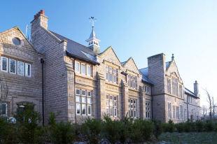
Ormskirk Grammar School Established 1610 Closed 2001 Type Grammar school, later comprehensive Location Ruff Lane
Ormskirk
Lancashire
L39 4QY
England
Local authority Lancashire Gender Mixed Ages 11–18 Coordinates: 53°33′54″N 2°52′46″W / 53.5650°N 2.8795°W
Ormskirk Grammar School was a school in Ormskirk, West Lancashire, England.
Contents
History
It was founded circa 1610 and moved from the original school house at Barkhouse Hill to Ruff Lane in 1850. The architect Sydney Smirke designed the original school room and school masters house which is to the west of the main school building. The school was consistently extended for the next 150 years to extend either side of Mill Street. It was situated in the east of the town, towards the hospital.
In the 1960s it had 750 boys and girls, and 850 in the early 1970s.
Comprehensive
It became a comprehensive in the late 1970s, year by year, with around 1,000 boys and girls.
Closure
It closed when the school amalgamated with Cross Hall High School, resulting in the formation of Ormskirk School in 2001 and was largely demolished to make way for housing in 2005 leaving only the original building on Ruff Lane which has now been converted into flats.
Alumni
- John Christie, Royal Mint executive
- Ray Connolly, novelist
- Rt Rev Frederick Charles Darwent, Bishop of Aberdeen and Orkney from 1978-92
- Vickey Dixon, hockey player
- Frederick Greer, 1st Baron Fairfield, Lord Justice of Appeal from 1927-38
- John Forshaw CB MC, architect, Chief Architect at the Ministry of Housing and Local Government from 1951-9
- Tom Frost, Group Chief Executive from 1987-92 of the National Westminster Bank
- Tom Middlehurst, Welsh Assembly Member from 1999-2003 for Alyn and Deeside
- Christine Morgan, Head of BBC Religion Radio since 2009, former Radio 4 producer, and married to Paul Vallely
- Sidney Procter CBE, Group Chief Executive from 1982-5 of the Royal Bank of Scotland Group, and Chief Executive from 1978-82 of Williams & Glyn's Bank
References
- History of Ormskirk Grammar School in Lancashire, David Orritt, 30 November 1988, Carnegie, ISBN 0948789263
External links
Categories:- Ormskirk
- Defunct grammar schools in England
- Educational institutions disestablished in 2001
- Educational institutions established in the 1610s
- Schools in West Lancashire
- Defunct schools in Lancashire
Wikimedia Foundation. 2010.