- Barajevo
-
Barajevo
Барајево— Municipality and Town — 
Coat of armsLocation of the municipality of Barajevo within Serbia
Coordinates: 44°35′N 20°25′E / 44.583°N 20.417°E Country Serbia District Belgrade Settlements 13 Government – Mayor Branka Savić (DS) Area[1] – Municipality 213 km2 (82.2 sq mi) Population (2011 census)[2] – Town 8,325 – Municipality 24,641 Time zone CET (UTC+1) – Summer (DST) CEST (UTC+2) Postal code 11460 Area code +381 11 Car plates BG Website www.barajevo.org.rs Barajevo (Serbian Cyrillic: Барајево, pronounced [bǎrajɛv̞ɔ]) is a suburban settlement and one of 17 municipalities which constitute the City of Belgrade, the capital of Serbia.
Contents
Municipality
Settlements
The municipality of Barajevo covers an area of 213 km² and includes 13 settlements, all of which are statistically classified as rural, not urban:
- Arnajevo
- Baćevac
- Barajevo
- Beljina
- Boždarevac
- Guncati
- Lisović
- Manić
- Meljak
- Rožanci
- Šiljakovac
- Veliki Borak
- Vranić
It also includes various sub-settlements and hamlets spawning around the central settlements:
- Bela Reka
- Dražanovac
- Dubrave
- Gaj
- Glumčevo Brdo
- Karaula
- Nenadovac
- Pajšuma
- Rašića Kraj
- Ravni Gaj
- Srednji Kraj
- Stara Lipovica
- Suva Šuma
- Taraiš
- Trebež
- Vitkovica
Population
Municipality has a population of 24,641 (census 2002), with an estimated 26,449 inhabitants on 31 December 2005 (124 per km²). Thanks to the immigration, it is one of the fastest growing areas of Belgrade, with an average annual growth of 2%. The rapid population growth is not followed by the equal development of infrastructure (good roads, waterworks, sewage system, waste disposal) even though in 2005 a construction of major water processing plant was finished. Two major traffic routes, the Ibarska magistrala (Highway of Ibar) and the railway Belgrade-Bar (Montenegro), are passing through the municipal territory.
Population of the municipality:
- 1961: 17,461
- 1971: 16,552
- 1981: 18,815
- 1991: 20,846
- 2002: 24,641
- 2005: 26.449
Ethnic structure (census 2002): Serbs 94,5%, Roma 0,8%, Montenegrins 0,7%.
Location
Municipality is located in the low part of Šumadija, southeast of the Belgrade, with an elevation spanning from 140 to 364 m. Most of the municipal territory belongs to the drainage area of the Turija river, right tributary of the Peštan river, which in turn flows into the Kolubara, thus whole area geographically gravitates to the Kolubara region.
History
Municipality was created in 1956 and immediately became administratively part of the wider Belgrade area. In 1957 a nearby municipality of Beljina was annexed to Barajevo, and in 1960 Umka municipality haas been divided between Čukarica and Barajevo (villages of Meljak and Vranić).
Recent presidents of the municipal assembly:
- 2000 - February 9, 2001; Zoran Jevtić (1947)
- February 9, 2001 - November 1, 2001; Miodrag Skoknić (1931) (acting)
- November 1, 2001 - February 20, 2003; Dragoljub Stanić (acting)
- February 20, 2003 - February 12, 2007; Rade Stevanović (1956)
- February 12, 2007 - February 21, 2007; Branislav Đurić (acting)
- February 12, 2007 - May, 2007; Rade Stevanović (second time)
- May, 2007 - June 25, 2007; Igor Jevtić (1975) (acting)
- June 25, 2007 - (present); Branka Savić (1956)
Settlement
Location and Population
The settlement itself is still statistically classified as a rural (village). It is growing by even higher rate than the municipality as a whole (census 2002, 8,325 inhabitants; estimate 31 December 2005, 9,231 inhabitants; annual growth rate of 2,9%). It is located east of the 'Parcanski vis' hill, northern part of the Kosmaj mountain, in the valley of the Beljanica river (or Barajevska reka; Cyrillic: Бељаница or Барајевска река), a tributary to the Turija river.
Population of the settlement:
- 1921: 2,330
- 1953: 3,361
- 1971: 3,486
- 1981: 4,225
- 1991: 6,093
- 2002: 8,325
- 2005: 9,231
Many outer settlements and hamlets are built as Barajevo grows and stretches in all directions making one continuous built-up are with the neighboring settlements (Guncati, Baćevac, Lisović, Boždarevac, Guberevac in Sopot municipality): Bela Reka, Dražanovac, Dubrave, Gaj (a separate local community with a population of 1,930 in 2002), Glumčevo Brdo (a separate local community, split after the 2002 census), Karaula, Nenadovac, Pajšuma, Ravni Gaj, Srednji Kraj, Stara Lipovica, Suva Šuma, Trebež (the industrial zone), Vitkovica.
Economy
The economy is not much developed. Being an agricultural area, Barajevo has a mill, large orchard farm, a veterinarian station and the hunting & forestry company of Lipovička šuma. Wheat, barley, oats and corn are being grown. Industry is based on the small construction and electronic companies and the ball bearing factory.
Barajevo is outside major roads, but it is located on the Belgrade-Bar railway. The settlement itself was further away, but as it grew, it reached the railway.
Culture and Tradition
Cultural festival, the Barlet, (Barajevo summer) is held annually. Artificial lake 'Duboki potok' (Cyrillic: Дубоки поток; Deep brook) is located near the Barajevo, with the large weekend-settlement.
First mention of the name Barajevo is from the 16th century. The popular story that the settlement got its name from the multitude of springs in this area [Serbian: bara je ovo (this is a pond)] is probably not true.
The Farm
Reality show The Farm is captures in village Lisović.[3]
See also
- Subdivisions of Belgrade
- List of Belgrade neighborhoods and suburbs
References
- Mala Prosvetina Enciklopedija, Third edition (1985); Prosveta; ISBN 86-07-00001-2
- Jovan Đ. Marković (1990): Enciklopedijski geografski leksikon Jugoslavije; Svjetlost-Sarajevo; ISBN 86-01-02651-6
- Srpska porodična enciklopedija, Vol. II (2006); Narodna knjiga and Politika NM; ISBN 86-331-2731-8
- ^ "Municipalities of Serbia, 2006". Statistical Office of Serbia. http://webrzs.stat.gov.rs/axd/en/Zip/OG2006webE.zip. Retrieved 2010-11-28.
- ^ "2011 Census of Population, Households and Dwellings in the Republic of Serbia – FIRST RESULTS". Bulletin (Statistical Office of the Republic of Serbia) 540. 2011. ISSN 0354-3641. http://media.popis2011.stat.rs/2011/prvi_rezultati.pdf. Retrieved 2011-11-21.
- ^ http://farma.rtvpink.com/?strana=7&vesti=1&sekcija=glavna&katv=1&jezik=1&broj=114&datum=2010-09-13
External links
Municipalities of Belgrade Municipalities Barajevo · Čukarica · Grocka · Lazarevac · Mladenovac · Novi Beograd · Obrenovac · Palilula · Rakovica · Savski Venac · Sopot · Stari Grad · Surčin · Voždovac · Vračar · Zemun · Zvezdara
Municipalities and cities of Serbia Central Serbia Belgrade (Barajevo • Čukarica • Grocka • Lazarevac • Mladenovac • Novi Beograd • Obrenovac • Palilula • Rakovica • Savski Venac • Sopot • Stari Grad • Surčin • Voždovac • Vračar • Zemun • Zvezdara) • Čačak • Jagodina • Kragujevac (Aerodrom • Pivara • Stanovo • Stari Grad • Stragari) • Kraljevo • Kruševac • Leskovac • Loznica • Niš (Crveni Krst • Medijana • Niška Banja • Palilula • Pantelej) • Novi Pazar • Požarevac • Smederevo • Šabac • Užice • Valjevo • Vranje • Zaječar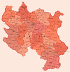 Aleksandrovac • Aleksinac • Aranđelovac • Arilje • Babušnica • Bajina Bašta • Batočina • Bela Palanka • Blace • Bogatić • Bojnik • Boljevac • Bor • Bosilegrad • Brus • Bujanovac • Crna Trava • Čajetina • Ćićevac • Ćuprija • Despotovac • Dimitrovgrad • Doljevac • Gadžin Han • Golubac • Gornji Milanovac • Ivanjica • Kladovo • Knić • Knjaževac • Koceljeva • Kosjerić • Krupanj • Kučevo • Kuršumlija • Lajkovac • Lapovo • Lebane • Lučani • Ljig • Ljubovija • Majdanpek • Mali Zvornik • Malo Crniće • Medveđa • Merošina • Mionica • Negotin • Nova Varoš • Osečina • Paraćin • Petrovac • Pirot • Požega • Preševo • Priboj • Prijepolje • Prokuplje • Rača • Raška • Ražanj • Rekovac • Sjenica • Smederevska Palanka • Sokobanja • Surdulica • Svilajnac • Svrljig • Topola • Trgovište • Trstenik • Tutin • Ub • Varvarin • Velika Plana • Veliko Gradište • Vladičin Han • Vladimirci • Vlasotince • Vrnjačka Banja • Žabari • Žagubica • Žitorađa
Vojvodina 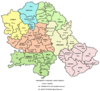 Ada • Alibunar • Apatin • Bač • Bačka Palanka • Bačka Topola • Bački Petrovac • Bečej • Bela Crkva • Beočin • Čoka • Inđija • Irig • Kanjiža • Kikinda • Kovačica • Kovin • Kula • Mali Iđoš • Nova Crnja • Novi Bečej • Novi Kneževac • Odžaci • Opovo • Pećinci • Plandište • Ruma • Sečanj • Senta • Šid • Srbobran • Sremski Karlovci • Stara Pazova • Temerin • Titel • Vrbas • Vršac • Žabalj • Žitište
Kosovo Dečani • Đakovica • Dragaš • Glogovac • Gnjilane • Istok • Kačanik • Klina • Kosovo Polje • Kosovska Kamenica • Kosovska Mitrovica • Leposavić • Lipljan • Mališevo • Novo Brdo • Obilić • Orahovac • Peć • Podujevo • Priština • Prizren • Štimlje • Srbica • Štrpce • Suva Reka • Uroševac • Vitina • Vučitrn • Zubin Potok • Zvečan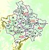 New Municipalities: Đeneral Janković • Gračanica • Junik • Klokot-Vrbovac • Mamuša • Parteš • RanilugPlanned Municipality: North Kosovska MitrovicaCategories:
- Municipalities of Belgrade
- Populated places in Central Serbia
- Suburbs of Belgrade


Wikimedia Foundation. 2010.