- Coates, West Sussex
-
Coordinates: 50°57′08″N 0°34′46″W / 50.95226°N 0.57937°W
Coates 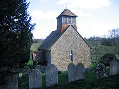
Church of St. Agatha
 Coates
Coates shown within West SussexOS grid reference SU998179 Parish Barlavington District Chichester Shire county West Sussex Region South East Country England Sovereign state United Kingdom Police Sussex Fire West Sussex Ambulance South East Coast EU Parliament South East England UK Parliament Horsham List of places: UK • England • West Sussex Coates Castle Site of Special Scientific Interest 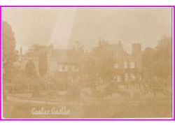

 Shown within West Sussex
Area of Search West Sussex Grid reference SU991175 Coordinates 50°56′54″N 0°35′18″W / 50.9483°N 0.588398°W Interest Biological Area 7.59 ha (18.8 acres) Notification 1993 Natural England website Coates is a downland village in the Chichester district of West Sussex, England. Coates lies one mile (1.7 km) southwest from Fittleworth and four miles (6.8 km) south-east-by-south from Petworth. It is within the ancient divisions of the Bury Hundred and the Rape (county subdivision) of Arundel.The village is bounded north by the Rother Navigation.
Contents
St Agatha's Church,
The Anglican church of St Agatha[1] is first recorded in about 1100 in the Chartulary of Lewes Priory, stating that the Church of "Cotes" made an annual donation to the Prior. The church is of early English style and consists of a single nave now covered by a wood floor with a bellcote (rebuilt 1961) and a small square chancel. The chancel arch is plain and half circular. One Norman window has survived on the south wall. The larger windows are late 14th century and of early English lancet type. A small Sussex marble lead-lined font stands extant at the west end of the nave[2] and constructed within the south wall of the chancel is a sedile ( pl sedilia) or priest's chair. Unusually the entrance to the church is on the north side presumably for the ease of the residents from the nearby manor house Coates Manor.[3] The Registers date from 1559[3] and the living is linked to nearby Burton,(West Sussex) (Bodecton). Since 1982 St Agatha's has been within the parish of Barlavington and Sutton and Bignor.
Coates Manor House
Coates Manor House is Elizabethan in origin and the former seat of the Coates family whose name is given to the village. It is well known for its gardens which are available for public viewing by appointment as part of the National Gardens Scheme.[4]
Coates Castle
Coates Castle, a Grade-II mansion listed by English Heritage lies on land above the village in a position that affords extensive views across the Sussex countryside. It was built in 1820 by John King in the Strawberry Hill gothic style and was extensively renovated in the early twenty first century after years of gradual decline. It is the place where Louisa Hamilton, Duchess of Abercorn, an ancestor of Princes William and Harry, died on 31 March 1905.(There is a memorial inside the church commemorating her life) and visitors to the house are known to have included Sir Winston Churchill and Kaiser Wilhelm. In the fifties it was owned by the former Master of the Hursley and Hambledon Hunt Gerald Joynson who renovated it and eccentrically installed in a room a specially constructed coffin for himself[5]
During the Second World War it was requisitioned and used by the army. It was here in 1940-41 that Lieutenant- colonel Stewart Blacker invented the Spigot Mortar or Blacker Bombard a cheap and easily produced piece of anti-tank ordinance required after the British Army's heavy equipment at been lost at Dunkirk. It was used extensively by the Home Guard[6]
Conservation area
Coates contains a Site of Special Scientific Interest as designated by English Nature. This consists of three blocks of land all within a one kilometre radius of Coates Castle and which contains an important British population of the Field Cricket Gryllus campestris, an insect protected under Schedule 5 of the Wildlife and Countryside Act 1981.[7] It is one of three known populations and the only one that was not subject to a reintroduction.
Coates Common and Lords Piece are areas of Sussex heathland containing breeding populations of heathland birds including Nightjar and Dartford Warbler.[8]
References
- ^ A Church Near You
- ^ J.L. Andre, Fonts in Sussex Churches, Sussex Archaeological Collections 44, 1901, # 35 drawing of font
- ^ a b The Sussex Archaeological Society: St Agatha's Church, Coates: A Short Guide
- ^ Coates Manor
- ^ The Sussex Argus 2 January 2004
- ^ Oxford Dictionary of National Biography, Latham Valentine Stewart Blacker (1887–1964), Stuart Macrae, rev., first published Sept 2004, 770 words
- ^ (PDF) SSSI Citation — Coates Castle. Natural England. http://www.english-nature.org.uk/citation/citation_photo/1006512.pdf. Retrieved 4 April 2009.
- ^ Sussex Ornithological Society June 2007
External links
 Media related to Coates, West Sussex at Wikimedia CommonsCategories:
- Villages in West Sussex
- Grade II* listed buildings in West Sussex
- Sites of Special Scientific Interest notified in 1993
- Sites of Special Scientific Interest in West Sussex


Wikimedia Foundation. 2010.