- Deerfoot Trail
-
Deerfoot Trail 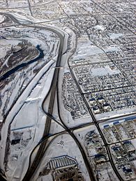
Deerfoot Trail at the interchange with Peigan Trail looking NorthLocation: Calgary, Alberta Deerfoot Trail is a freeway section of the Queen Elizabeth II Highway (Highway 2) in Calgary, Alberta, Canada. It was formerly known as Blackfoot Trail Freeway, but was renamed to honour the first Native American to win the marathon.
Deerfoot Trail stretches 50 kilometres (31 mi), from Calgary's northern city limit to its merger with Highway 2A (Macleod Trail) just north of Okotoks, and features 21 interchanges.[1] It is Alberta's busiest highway with traffic volumes ranging between 27,000 and 158,000 vehicles per day depending on the location.[1] Its busiest stretch is between Memorial Drive and 16 Avenue NE (Trans-Canada Highway). The majority of Deerfoot Trail is six lanes in total width, but there are a number of four-, eight- and ten-lane sections. The posted speed limit is 100 km/h (62 mph).
Deerfoot Trail was constructed in five stages:
- 1971 – northern City boundary to 16 Avenue NE;
- 1975 – 16 Avenue NE to 17 Avenue SE;
- 1980 – 17 Avenue SE to Glenmore Trail;
- 1982 – Glenmore Trail to Highway 22X (Marquis of Lorne Trail); and
- 2003 – Highway 22X to Highway 2 north of Okotoks.
In the fall of 2005, the last set of traffic signals was removed from Douglasdale Boulevard in southeast Calgary and replaced with a parclo interchange, rendering the road a freeway for its entire journey through the City of Calgary.
The province took over responsibility from the city for highway maintenance and upgrades. The road is currently maintained by Carmacks Enterprises between the northern city limit and the Macleod Trail merger.
There have been 10,000 collisions on Deerfoot Trail in the past five years, including 24 fatalities, according to the City of Calgary.[2]
References
- ^ a b Alberta Transportation (2010-11-03). "Deerfoot Trail construction wraps up busy year". http://alberta.ca/home/NewsFrame.cfm?ReleaseID=/acn/201011/294380E42E633-937C-CFC4-EB0F94E338D38795.html. Retrieved 2010-11-19.
- ^ Calgary Herald (May 2007). "Driver says barrier saved his life". http://www.canada.com/calgaryherald/news/story.html?id=1986bae0-b7a9-4013-9e89-448eb011fde1&k=43275. Retrieved 2007-05-07.
See also
Roads in Calgary, Alberta North-south routes Nose Hill Drive • Sarcee Trail • Shaganappi Trail • Crowchild Trail · Centre Street · Macleod Trail · Edmonton Trail • Blackfoot Trail • Deerfoot Trail • Barlow Trail • Metis Trail • 52 Street EEast-west routes Country Hills Boulevard • Beddington Trail • Airport Trail • McKnight Boulevard • John Laurie Boulevard • Memorial Drive • Bow Trail • 17 Avenue SW • 17 Avenue SE • Heritage Drive • Southland Drive • Anderson Road • Canyon Meadows DriveHighways and expressways 1 (16 Avenue N) · 1A (Crowchild Trail) · 2 (Deerfoot Trail) · 2A (Macleod Trail) · 8 (Glenmore Trail) · 22X (Marquis of Lorne Trail) · 201 (Stoney Trail) • 560 (Glenmore Trail) • 563 (Old Banff Coach Road) • 772 (Symons Valley Road) • 773 (37 Street SW)Highways in Alberta 
Expressways
and FreewaysNamed
HighwaysAnthony Henday · Bicentennial · Bighorn · Bow Valley Parkway · Bow Valley Trail · Buffalo · Cowboy · Crowsnest · David Thompson · Devonian Way · Dinosaur · Forestry Trunk · Grizzly · Hoo Doo Trail · Icefields Parkway · Mackenzie · Northern Woods and Water Route · Parkland · Poundmaker · Queen Elizabeth II · Red Coat Trail · Sherwood Park Freeway · Stoney · Trans-Canada · Veterans Memorial · Yellowhead1-216 Series 1 · 1A · 1X · 2 · 2A · 3 · 3A · 4 · 5 · 6 · 7 · 8 · 9 · 10 · 10X · 11 · 11A · 12 · 13 · 13A · 14 · 15 · 16 · 16A · 17 · 18 · 19 · 20 · 20A · 21 · 22 · 22X · 23 · 24 · 25 · 26 · 27 · 28 · 28A · 29 · 31 · 32 · 33 · 35 · 36 · 37 · 38 · 39 · 40 · 41 · 41A · 42 · 43 · 44 · 45 · 47 · 49 · 50 · 52 · 53 · 54 · 55 · 56 · 58 · 59 · 60 · 61 · 62 · 63 · 64 · 64A · 66 · 68 · 69 · 72 · 88 · 93 · 93A · 100 · 201 · 216Categories:- Freeways in Alberta
- Roads in Calgary
- Alberta road stubs
- Calgary stubs

Wikimedia Foundation. 2010.