- Opticks (software)
-
Opticks 
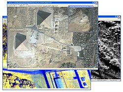
Imagery of the pyramids.Developer(s) Ball Aerospace & Technologies Corp. Initial release May 2, 2001 Stable release 4.7.0 (June 17, 2011) [+/−] Preview release 4.7.0 rc2 (June 9, 2011) [+/−] Written in C++, Python Operating system Windows XP & Windows XP x64, Linux, Solaris 10 Available in English Type Remote sensing application License LGPL 2.1 Website http://opticks.org/ Opticks is an open source, remote sensing application that supports imagery, video (motion imagery), Synthetic Aperture Radar (SAR), multi-spectral, hyper-spectral, and other types of remote sensing data. Opticks is unlike other remote sensing applications because it treats imagery and video alike. Opticks is one of the only remote sensing applications that supports processing remote sensing video. Opticks was initially developed by Ball Aerospace & Technologies Corp. and other organizations for the United States Intelligence Community. Ball Aerospace open sourced Opticks hoping to increase the demand for remote sensing data and broaden the features available in existing remote sensing software. The Opticks software and its plug-ins are developed by over twenty different organizations.
Opticks can also be used as a remote sensing software development framework. Developers can extend Opticks functionality using its plug-in architecture and public application programming interface (API). Opticks is open source, licensed under GNU Lesser General Public License (LGPL) 2.1. Opticks was brought into the open source community in Dec 2007 and has a large developer community. Over two hundred developers are registered on its site and over twenty different organizations are developing plug-ins.
See also
- Remote sensing
- Synthetic aperture radar
- Hyperspectral
- Multispectral
- Imagery analysis
- LIDAR
- RADAR
- Open-source software
References
- Opticks Website - Open Source website managed by CollabNet
- CNET Article - Open source in the US Department of Defense: the Opticks story
- Yahoo Article - Ball launches open source software
External links
Categories:- Remote sensing software
- Remote sensing
- Windows software
- Solaris software
- Free software programmed in C++
- 2001 software


Wikimedia Foundation. 2010.