- Mexico City Metrobús
-
Mexico City Metrobús 
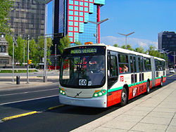
Metrobús on Avenida de los Insurgentes crossing Paseo de la ReformaFounded 2005 Locale Mexico City Service type bus rapid transit Routes 3 Stops 114 Fleet 269 Articulated buses
+ 13 Bi-articulated buses
= 282 total[1]Web site www.metrobus.df.gob.mx (in Spanish) Metrobús is a bus rapid transit (BRT) system in Mexico City, Mexico. It comprises 3 lines that traverse the city and connect with other forms of transit. It was officially opened to the public with service along Line 1 on 19 June 2005. Line 2 opened on 16 December 2009,[2] and Line 3 opened on 8 February 2011.[3]
Contents
Routes and Hours

The first line covers a distance of up to 30 kilometres (19 mi), running in a dedicated bus-lane built within the central reservation (median) of Avenida de los Insurgentes.[4] Avenida Insurgentes is one of the city's main north-to-south arterial routes, constitutes a section of the Pan-American Highway, and is reputed to be the longest urban avenue in the world.
This line starts at Metro Indios Verdes, a large multimodal transport node in the Gustavo A. Madero borough. From there it runs south, through Cuauhtémoc and Benito Juárez, before terminating in the La Joya[disambiguation needed
 ] district of Tlalpan borough, providing a total of 45 stations. It was built in two sections, with a split at Metro Insurgentes, the notional dividing point between the avenue's northern and southern stretches, just south of where Avenida Insurgentes intersects with Paseo de la Reforma.
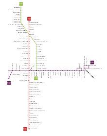 System map
On its route south from Indios Verdes, the Metrobús also connects with Metro stations at Deportivo 18 de Marzo, Potrero, La Raza, Buenavista, Revolución, Insurgentes, and Chilpancingo, providing connections with Metro Lines 1, 2, 3, 5, 6, and 9. The proposed southward extension of Mexico City Metro Line 7 will also enable that line to connect at the Metrobús' original southernmost station, Doctor Gálvez.[citation needed]

Line 2 runs 20 kilometres (12 mi) from Tacubaya in the west, where there is a connection to the Metro Tacubaya station; to Tepalcates in the east, where there is a connection to the Metro Tepalcates station.[5]

Line 3 runs 17 kilometres (11 mi) from Tenayuca northwest of the city southward to Etiopía II, where there is connection to Metrobús Line 2 as well as the Metro Etiopía station.[3]
The MB operates from 04:30 to 24:00 (midnight) Monday through Friday, and from 05:00 to 24:00 on Saturdays, Sundays and Holidays. Hours for individual stations may vary in the mornings.[1] A flash-based map of the system is available at the Metrobús website.[5]
History
The Mexico City Metrobús was opened along the northern most portion of Line 1 on 19 June 2005.[4] Initial service was from Metro Indios Verdes south to Metro Insurgentes. This was quickly followed by a southward expansion from Metro Insurgentes to MB station Doctor Gálvez, bringing the line length up to 20 kilometres (12 mi). Many of the stations along Line 1 feature cantilevered glass canopies designed by architect Carlos Monge.[6]
Before and after
The system replaced 372 standard buses and microbuses that served Avenida de los Insurgentes with 212 articulated buses that run at an average speed of 20 km/h (12 mph), doing 60 km/h (37 mph) as maximum. Doing so, travel times along the corridor are reduced up to 50%.[citation needed]
Environmental impact
Besides addressing the bus service problem, the BRT Metrobús project emerged in the context of the city’s efforts to reduce Air pollution in Mexico City with a program called Proaire 2002-2010.[7] According to Metrobús, annual environmental benefits include a reduction of 35,400 long tons (36,000 t) of Carbon dioxide, 9,700 long tons (9,900 t) of Carbon monoxide, 206 long tons (209 t) of NOx, and 1.27 long tons (1.29 t) of PM10 particulates.
Capacity and traffic
According to information from the Mexico City government published in April 2006, the Metrobús carried more than 260,000 passengers daily.
2008 expansion
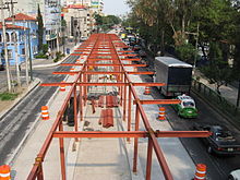 MB station Xola under construction near the intersection of Eje Central and Eje 4 Sur, 25 August 2008
The original Line 1 was expanded with the inclusion of nine new stations in order to achieve full coverage of Avenida Insurgentes. The southward expansion of service along Line 1 started service on 13 March 2008 and brought the line's length up to 30 kilometres (19 mi).[4]
A second Metrobús line was also built in 2008, running west to east along Eje 4 Sur. This second line connects Metro Tacubaya, Etiopía, Patriotismo and with the Insurgentes Metrobús at its Nuevo León stop, and was opened on 16 December 2009.[2]
2010 expansion
According to the Mexican newspaper, El Universal, construction of the first 16 km (9.9 mi) of Línea 3 (line 3) began on 5 March 2010 and was scheduled to end in April 2011.[8] However, service along Line 3 started on 8 February 2011.[3] During construction, for every tree taken down three were planted, for a total of 1,546 trees planted. In addition, it was estimated that Line 3 will carry 100,000 passengers per day.[8] Travel time will be reduced by up to 40%.
2011 expansion

In late 2010 the Head of Government of the Federal District Marcelo Ebrard announced a plan to build a new Metrobús Line 4 that would run from near Buenavista Station in the west of the city eastward towards Mexico City International Airport.[9] Construction on Line 4 started on 4 July 2011,[10] although the start of construction was met with some protest from residents and business owners along the proposed route.[11]
The plans for Line 4 include a two step construction process with the first 28 kilometres (17 mi) operational segment to be built between Buenavista and Metro San Lázaro.[12] A later extension would provide travel between San Lázaro and the Airport.[12] Instead of travelling along a single avenue or axis road Line 4 traffic will circulate around the Centro Histórico.[12] To navigate the turns and narrow streets in and near the Centro Histórico Line 4 will use 12-metre (39 ft) long light buses instead of the 18-metre (59 ft) articulated buses used on the other lines in the system.[12] The stations for Line 4 will appear more like conventional bus stops and will be built at curbside instead of within a dedicated portion of a central reservation as used on the other lines.[12]
Passenger access and payment
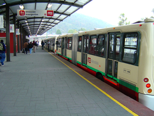
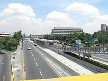 Southern section of Avenida de los Insurgentes seen from a bridge of the Periférico near the Perisur Mall, showing the Perisur MB station
Ticketing is by pre-paid proximity smartcard, which travellers have to pass through turnstiles at the entry to the separated bus platforms. During the early months of the system's operations, limited availability of the cards required a temporary method for access to the system involving purchasing a normal single-trip paper ticket at a cost of MXN$4.50. Starting in October 2005, and with smartcard supply able to cover the demand, access is done exclusively by using the card.
As of 2010, the single-trip cost is MXN$5.00 (about € 0.27 or US$ 0.38) A new MB smartcard, preloaded with one voyage, can be purchased for MXN$15.00 (≈ € 0.80/US$ 1.14) and "recharged" for MXN$5.00 per trip.
The smartcard system has generated controversy, especially from occasional and one-time users who complain about the MXN$15.00 fee for a single-voyage card, for this is common that sometimes people ask others who have the smartcard to charge for them a trip.
Service is free for those over 70 years old, or disabled, as well as for children under 5 accompanied by an adult.[13]
List of stations
- Official name (if any) in brackets. Metro stations in italics are the nearest, though not interconnected.
 Indios Verdes Station.
Line 1 (Avenida Insurgentes) Indios Verdes - El Caminero
- Indios Verdes <->
 Indios Verdes
 - Deportivo 18 de Marzo <->
 Deportivo 18 de Marzo
 - Euzkaro >>> Deportivo 18 de Marzo
- Potrero <-> Potrero
- La Raza <->
 La Raza
 - Circuito >>> La Raza
- San Simón >>> Tlatelolco
- Manuel González >>> Tlatelolco
- Buenavista <->
 Buenavista
 - El Chopo >>> Buenavista
- Revolución <->
 Revolución
 - Tabacalera >>> Revolución
- Reforma >>> Revolución
- Hamburgo >>>
 Insurgentes
 - Insurgentes (Glorieta de los Insurgentes) <-> Insurgentes
- Durango >>> Insurgentes
- Álvaro Obregón >>> Insurgentes
- Sonora >>>
 Chilpancingo
 - Campeche >>> Chilpancingo
- Chilpancingo <-> Chilpancingo
- Nuevo León
- La Piedad
- Poliforum (Poliforum Siqueiros)
- Nápoles
- Colonia del Valle
- Ciudad de los Deportes >>>
 San Antonio
 - Parque Hundido >>>
 Insurgentes Sur
 - Félix Cuevas <-> Insurgentes Sur
- Río Churubusco >>> Insurgentes Sur
- Teatro Insurgentes >>> Barranca del Muerto
- José María Velasco >>> Barranca del Muerto
- Francia >>> Barranca del Muerto
- Olivo
- Altavista >>> Miguel Ángel de Quevedo
- La Bombilla >>> Miguel Ángel de Quevedo
- Doctor Gálvez
- Ciudad Universitaria >>> Universidad
- Perisur >>> Universidad
- Villa Olímpica
- Corregidora
- Ayuntamiento
- Fuentes Brotantes
- Santa Úrsula
- La Joya
- El Caminero (Monumento al Caminero)
Line 2 (Eje 4 Corredor) Tacubaya - Tepalcates
- Tacubaya <-> Tacubaya
- Parque Lira
- Antonio Maceo
- De la Salle
- Patriotismo <-> Patriotismo
- Escandón
- Nuevo León
- Viaducto
- Amores
- Etiopía/Plaza de la Transparencia <-> Etiopía
- Doctor Vértiz
- Centro SCOP
- Álamos
- Xola <-> Xola
- Las Américas
- Andrés Molina
- La Viga >>>
 Santa Anita
 - Coyuya >>>
 Coyuya
- Canela
- Tlacotal
- Goma
- Iztacalco
- UPIICSA
- El Rodeo
- Río Tecolutla
- Río Mayo
- Rojo Gómez
- Río Frío
- Del Moral
- Leyes de Reforma
- CCH Oriente
- Constitución de Apatzingán
- Canal de San Juan <->
 Canal de San Juan
 - Nicolás Bravo
- Gral. A. de León
- Tepalcates <-> Tepalcates
Line 3 (Eje 1 Poniente) Tenayuca - Etiopía
- Tenayuca
- San José de la Escalera
- Progreso Nacional
- Tres Anegas
- Júpiter
- La Patera
- Poniente 146 >>> Politécnico
- Montevideo
- Poniente 134 >>> Vallejo
- Poniente 128
- Magdalena de las Salinas
- Coltongo >>> Autobuses del Norte
- Cuitláhuac
- Héroe de Nacozari
- Hospital La Raza
- La Raza 2
- Circuito >>> La Raza
- Tolnahuac
- Tlatelolco
- Ricardo Flores Magón
- Guerrero >>> Guerrero
- Buenavista II >>> Buenavista
- Mina
- Hidalgo >>> Hidalgo
- Juárez
- Balderas
- Cuauhtémoc >>> Cuauhtémoc
- Jardín Pushkin
- Hospital General >>> Hospital General
- Doctor Márquez
- Centro Médico >>> Centro Médico
- Obrero Mundial
- Etiopía/Transparencia <-> Etiopía
See also
- Servicio de Transportes Eléctricos
References
- ^ a b "Metrobús - Ciudad de México: FAQ" (in Spanish). Sistema de Corredores de Transporte Público de Pasajeros del D.F., Metrobús. http://www.metrobus.df.gob.mx/faq.html. Retrieved 17 September 2011.
- ^ a b "Metrobús - Ciudad de México: Ficha técnica de Línea 2" (in Spanish). Sistema de Corredores de Transporte Público de Pasajeros del D.F., Metrobús. http://www.metrobus.df.gob.mx/fichas.html#dos. Retrieved 17 September 2011.
- ^ a b c "Metrobús - Ciudad de México: Ficha técnica de Línea 3" (in Spanish). Sistema de Corredores de Transporte Público de Pasajeros del D.F., Metrobús. http://www.metrobus.df.gob.mx/fichas.html#tres. Retrieved 17 September 2011.
- ^ a b c "Metrobús - Ciudad de México: Ficha técnica de Línea 1" (in Spanish). Sistema de Corredores de Transporte Público de Pasajeros del D.F., Metrobús. http://www.metrobus.df.gob.mx/fichas.html#uno. Retrieved 17 September 2011.
- ^ a b "Metrobús - Ciudad de México: Mapa de Sistema" (in Spanish). Sistema de Corredores de Transporte Público de Pasajeros del D.F., Metrobús. http://www.metrobus.df.gob.mx/mapa.html. Retrieved 17 September 2011.
- ^ "Metrobus" (in Spanish). Fideicomiso para el Mejoramiento de las Vías de Comunicación del Distrito Federal. http://www.fimevic.df.gob.mx/metrobus/default.htm. Retrieved 17 September 2011.
- ^ "PROAIRE 2002-2010" (in Spanish). Secretaría del Medio Ambiente del Gobierno del Distrito Federal. 12 July 2004. http://www.sma.df.gob.mx/sma/index.php?opcion=26&id=253. Retrieved 17 September 2011.
- ^ a b Balboa, Berenice (12 May 2010). "Aceleran construcción de la Línea 3 del Metrobús" (in Spanish). El Universal. http://www.eluniversal.com.mx/notas/679781.html. Retrieved 2010-05-19.
- ^ Robles, Johana (28 November 2010). "L-4 de Metrobús arranca a principios de 2011: GDF" (in Spanish). El Universal (Mexico City). http://www.eluniversal.com.mx/ciudad/104254.html. Retrieved 18 September 2011.
- ^ Robles, Johana (4 July 2011). "Inicia construcción de L4 del Metrobús" (in Spanish). El Universal (Mexico City). http://www.eluniversal.com.mx/edomex/4927.html. Retrieved 18 September 2011.
- ^ Robles, Johana (4 July 2011). "Comerciantes se manifiestan contra L4 de Metrobús" (in Spanish). El Universal (Mexico City). http://www.eluniversal.com.mx/notas/777003.html. Retrieved 18 September 2011.
- ^ a b c d e "Metrobús - Ciudad de México: Línea 4" (in Spanish). Sistema de Corredores deTransporte Público de Pasajeros del D.F., Metrobús. http://www.metrobus.df.gob.mx/linea4.html. Retrieved 17 September 2011.
- ^ "Metrobús - Ciudad de México: Gratuidad" (in Spanish). Sistema de Corredores de Transporte Público de Pasajeros del D.F., Metrobús. http://www.metrobus.df.gob.mx/beneficios.html. Retrieved 17 September 2011.
External links
- Metrobús official website - In Spanish
 Urban public transport networks and systems in Mexico
Commuter rail 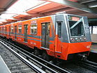
Rapid transit Light rail Trolleybus Trolleybuses in Guadalajara · Trolleybuses in Mexico CityBus rapid transit Guadalajara Macrobus · Metrobús of Mexico CityMultimodal operating authorities Servicio de Transportes Eléctricos (Mexico City)Categories:- Transportation in Mexico City
- Bus companies of Mexico
- Bus rapid transit in Mexico


Wikimedia Foundation. 2010.