- List of countries spanning more than one continent
This is a list of countries spanning more than one continent, sometimes referred to as transcontinental states. The definitions of what
continent (s) a particularcountry covers may vary according to which criteria are used (whether purely geographical or geological or, on the other hand, political, economic or cultural criteria). An example isRussia , which has its historical core as well as most of its population (72%), economic activity and political institutions (such as its capital city) inEurope , yet "geographically" most of the territory (71%) is actually inAsia .The article
borders of the continents describes the details and disputes of continental boundaries, which are reflected in this list.Separately listed below are 1.) countries whose contiguous continental territory or where nearby islands lie in two (or more) different continents, and 2.) distant non-contiguous parts lie on a different continent than the rest of the country.
Contiguous boundary
Africa and Asia
:"See
Borders of the continents for more details about the geographical border between Africa and Asia."The border betweenAsia andAfrica is considered to go along the Isthmus of Suez and theSuez Canal inEgypt . The border continues through theGulf of Suez ,Red Sea andGulf of Aden .Yemen controlsHanish Islands in the Red Sea which lie beyond this border,Fact|date=September 2008 as well asSocotra , so it has non-contiguous island territory in Africa, but is not considered a transcontinental country.Egypt
Three of 29 governorates of
Egypt lie entirely on AsianSinai Peninsula and two are transcontinental:Ismailia Governorate is nearly equally divided by theSuez Canal , andSuez Governorate , which is coterminous with thetranscontinental city ofSuez , has a small portion east of the Canal.Asia and Europe
:"See Borders of the continents for more details about the geographical border between
Europe andAsia .":"See also Geographic criteria for EU membership."Western sources, such as the National Geographic Society, usually state that the Europe-Asia boundary follows the watershed of the
Ural Mountains to the source of theUral River , then follows that river to theCaspian Sea . The border then follows the watershed of the Caucasus Mountains from the Caspian Sea to the Black Sea. This is the definition illustrated in this section, although variations exist.*
Azerbaijan - situated in Eastern Europe and Western Asia.
* Georgia - situated in Eastern Europe and Western Asia. [As atranscontinental country , Georgia may be considered to be inEurope and/orAsia . The UN [http://unstats.un.org/unsd/methods/m49/m49regin.htm classification of world regions] places Georgia inWestern Asia ;CIA world factbook and " [http://www.britannica.com/ebc/article-9365466 Encyclopædia Britannica] " also place Georgia in Asia. Conversely, numerous sources place Georgia in Europe such as theEuropean Union [http://europa.eu/abc/european_countries/others/georgia/index_en.htm] ,BBC [http://news.bbc.co.uk/2/hi/europe/country_profiles/1102477.stm] , "Oxford Reference Online" [http://www.oxfordreference.com/views/ENTRY.html?entry=t186.e21064&srn=1&ssid=416740626#FIRSTHIT] , " [http://www.m-w.com/dictionary/Georgia Merriam-Webster's Collegiate Dictionary] ", and [http://worldatlas.com/webimage/countrys/eu.htm www.worldatlas.com] . Georgia is a Member ofCouncil of Europe ]
*Kazakhstan - situated in Central Asia and Eastern Europe.
*Russia - situated in Northern Asia and Eastern Europe.
*Turkey - situated in Western Asia and Southeastern Europe.Azerbaijan
The northeastern Azerbaijan district borders run mostly along the main Caucasus watershed. Five districts are entirely within Europe, and the transcontinental
Khizi district is almost equally divided on the two sides of the watershed. Azerbaijan is a member of the Council of Europe.Georgia
Georgia's regional borders cross the main Caucasus watershed perpendicularly in the east-central region of the country, though some of its subdivisional lines follow it. Georgia's three transcontinental regions are
Shida Kartli ,Mtskheta-Mtianeti , andKakheti .The Java district of Shida Kartli is transcontinental (mostly in Europe) and the region's other four districts are entirely within Asia. The Kazbegi and Dusheti districts of Mtskheta-Mtianeti are transcontinental, with the
Khevi subdivision of Kazbegi and theKhevsureti subdivision of Dusheti being entirely in Europe and theMtiuleti subdivision of Kazbegi being transcontinental, and the region's other three districts are entirely within Asia. TheAkhmeta district of Kakheti is transcontinental, with itsTusheti subdivision in Europe, and the region's other seven districts are entirely within Asia. Georgia is a member of the Council of Europe.South Ossetia includes the northern half of Shida Kartli (including Java) and very small portions of the three neighbouring Georgian regions. [http://en.wikipedia.org/wiki/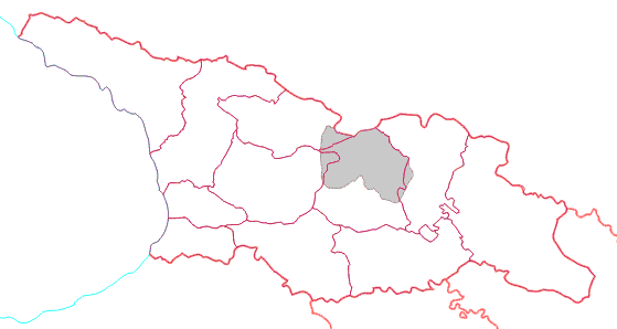
]Kazakhstan
Kazakhstan's provincial borders don't follow the Ural River, although some of its western district borders do so. Two of the provinces are transcontinental,
Atyrau Province andWest Kazakhstan Province . The capital of the former,Atyrau , is split by the mouth of the Ural and is atranscontinental city . Almost all of it is in Asia with a small portion in Europe. Two of Atyrau Province's districts are entirely in Europe, three of its districts are entirely in Asia, and its Inderskiy and Makhambetskiy districts are transcontinental. [ [http://www.brif.kz/eng/maps/atyrau_region.php www.brif.kz] ] Five of West Kazakhstan's districts and the province's capital city of Oral are entirely in Europe, five of its districts are entirely in Asia, and its Akzhaikskiy district is transcontinental. [ [http://www.brif.kz/eng/maps/west_kaz_region.php www.brif.kz] ]Russia
Russian regions' borders follow the
Ural Mountains andUral River closely enough. There is a very small area (less than 300 km²) of Russian territory south of the main Caucasus watershed in Asia.Orenburg on the Ural River is atranscontinental city . More detail on the political divisions through which the intercontinental boundary runs can be found here. Russia is a member of the Council of Europe.Turkey
Three of Turkey's provinces are entirely in Europe while Çanakkale and Istanbul are transcontinental provinces. Three of Çanakkale's districts are entirely in Europe and its other nine districts are entirely in
Asia . Nineteen of Istanbul's districts are entirely in Europe and its other twelve districts (formingAnatolia ) are entirely in Asia.North and South America
:"See Borders of the continents and
South America pages for more details about the geographical border between the two Americas."Panama
Most authorities and most Panamanians consider
Panama to beNorth America 's southernmost nation, entirely within bothCentral America and North America. An alternative view is that the man-madePanama Canal , being a concrete line to demarcate theIsthmus of Panama, divides the continents. That would placeDarién Province and four "comarca s indígenas" entirely in South America.Panamá Province andColón Province would both be transcontinental, with Colón nearly equally divided between both Americas and Panamá Province unequally divided, with nearly a 1:4 ratio in South America's favour. A map of the locations of the districts of these two provinces and their area and population numbers is needed. ThePearl Islands andTaboga Island in theGulf of Panama are part of Panamá Province and would be associated with South America and North America, respectively. Six other provinces and the "comarca indígena" ofNgöbe-Buglé would be entirely in North America.Non-contiguous
Africa and Europe
:"See Borders of the continents for more details about the geographical border between
Africa andEurope ."* Italy: Although mainland
Italy ,Sardinia ,Sicily , theAegadian Islands ,Ustica , and theAeolian Islands are associated withEurope , the closest land toPantelleria and thePelagie Islands isTunisia on the African mainland. They belong to the transcontinental Sicilian provinces of Trapani and Agrigento, respectively, and they are coterminous with the "comuni " of Pantelleria andLampedusa e Linosa , respectively.
* Malta:Malta has been geopolitically European in modern times, but may be considered geographically associated with Africa. More detail may be found here.
* Portugal:Continental Portugal is inEurope , while theAzores archipelago (also associated with Europe) and the archipelago ofMadeira (geographically part ofAfrica ) in theAtlantic Ocean constitute theAutonomous regions of Portugal . The Azores has two islands (Corvo and Flores) that are part of the American plate while the latter region also includesPorto Santo Island , theDesertas Islands , and theSavage Islands , all of which are in fact African islands.
* Spain: Although its mainland is inEurope ,Spain has holdings (theCanary Islands in the Atlantic and its "Plazas de soberanía " includingCeuta and Melilla on the African mainland) that are geographically part ofAfrica . They are consideredAutonomous communities of Spain . The African Mediterranean island ofIsla de Alborán belongs to thetranscontinental city ofAlmería and the transcontinental province of Almería.Asia and Africa
* Yemen: Although mainland
Yemen is in the southernArabian Peninsula and thus part ofAsia , and itsHanish Islands andPerim in theRed Sea are associated with Asia, Yemen controls thearchipelago ofSocotra , which lies east of the horn ofSomalia and is much closer toAfrica thanAsia . Socotra and the mainland city ofAden constitute the transcontinental'Adan Governorate .Asia and Oceania
*
Indonesia : Indonesia is commonly associated with Asia,Southeast Asia orMalay Archipelago . However, eastern provinces of Indonesia fromWallace Line to east are geographically associated with Oceania such asWest Nusa Tenggara ,East Nusa Tenggara , Maluku,North Maluku , West Papua and Papua. [Indonesia is generally considered a territory of Southeastern Asia (UN region); wholly or partially, it is also frequently included inAustralasia orMelanesia . Maps or atlases usually include Indonesian portion ofNew Guinea (Irian Jaya ) andMaluku Islands .
]* East Timor:
East Timor is classified as Asian by the United Nations, [ [http://www.un.org/depts/dhl/maplib/worldregions.htm UN World Macro Regions and Components] ] and a member of theASEAN Regional Forum . [ [http://www.smh.com.au/news/world/east-timor-asean-bid/2006/07/22/1153166635002.html smh.com.au] ] East Timor has applied for membership of theAssociation of Southeast Asian Nations (ASEAN), at which it is an observer; it is also an observer at thePacific Islands Forum (PIF). Biogeographically, East Timor lies withinWallacea , an ecological transition zone between Asia andAustralasia .cite book |last=Severin |first=Tim |title=The Spice Island Voyage: In Search of Wallace |publisher=Abacus Travel |year=1997 |location=Great Britain |id=ISBN 0-349-11040-9] The Portuguese sources, "Lello Universal" and "Enciclopédia Luso-Brasileira", described Timor as being in Oceania. The social organization of its tribal population is extremely similar to societies in Oceania. [Marcos, Artur. Timor Timorense - Com suas línguas, literatura, lusofonia. Colibri Editions, 1995. ISBN972-8288-11-5] The languages spoken in the territory are mainlyAustronesian , the same group that comprises the languages ofMaritime Southeast Asia which includesMalaysia ,Indonesia , andthe Philippines , and also New Guinea which is usually considered as part ofMelanesia . [ [http://www.ethnologue.com/show_country.asp?name=TL Languages of East Timor] ]*
Australia : TheCommonwealth of Australia consists of its namesake continent and island possessions associated with Oceania, Asia, andAntarctica . Its Indian Ocean island possessions ofChristmas Island and theCocos (Keeling) Islands are associated withAsia . The majority of the ancestry of Australia's Asian island residents is Asian and the majority of them are Muslim or Buddhist.* Japan: All of
Japan consists of Asian islands except for the remote and uninhabitedMinami Torishima , which is an Oceanian island and administratively part of the city ofTokyo and the subdivision of Ogasawara Village, along with other outlying Japanese islands to the south and southeast of the city.Fact|date=November 2007North America and Oceania
* While the territory of the
United States lies overwhelmingly in North America, it includes the state ofHawaii inOceania , as well as other Oceanian island possessions and Alaskan islands on NE Asia's continental shelf.North and South America
* Most geographic authorities delineate the land border dividing the Americas somewhere along the
Isthmus of Panama . The most common demarcation follows the Darien watershed along the Colombia-Panama boundary. A less common dividing line (but used herein) is thePanama Canal transecting the isthmus; by that definition,Panama would be reckoned to have territory in both continents.Panama City , Panama's capital, sits on the Pacific (southern) coast near the Panama Canal in the eastern (South American) portion of the country. Panama lies almost entirely on theCaribbean Plate , with a small portion on the South American Plate. Geopolitically and geographically, all of Panama is generally considered a part of North America alone and among the countries ofNorth America .
* The sea islands division is more complicated. AllCaribbean islands are often labeled as North American. The Dutch dependencyAruba , some parts of theNetherlands Antilles (Bonaire andCuraçao islands), and the state ofTrinidad and Tobago lie on thecontinental shelf of South America, and are considered South American.Venezuela 'sIsla Aves and theColombia n islands ofSan Andrés and Providencia are geographically North American. Isla Aves is one of theFederal dependencies of Venezuela under the administration of thetranscontinental city ofCaracas . North American Caribbean islands belonging to South American countries: South American Caribbean islands:*
Aruba : Lies on the continental shelf of South America, and is thus considered to lie entirely inSouth America , but all Caribbean islands are often labelled as North American, and the language and cultural links are not to South America.
*Colombia: MainlandColombia is in northwesternSouth America andMalpelo Island in thePacific Ocean is also associated with South America, but the nation also controls theSan Andrés and Providencia archipelago , 400 miles WNW of Colombia's Caribbean coast, near the Caribbean coast ofNicaragua . This archipelago is coterminous with the department of the same name.
*Netherlands Antilles :Bonaire andCuraçao lie entirely inSouth America because of the position of the continental shelf, whileSaba ,Sint Eustatius , andSint Maarten lie entirely inNorth America . Similarly to Aruba, its historical connections are with the other Caribbean islands that are often labelled as North American, and the language and cultural links are not to South America but increasingly because of tourism and the financial industry to other English speaking Caribbean nations.
*Trinidad and Tobago : Lies on the continental shelf of South America, and is thus considered to lie entirely inSouth America , but all Caribbean islands are often labelled as North American, and the language and cultural links are not to South America but to the rest of the English speaking Caribbean nations.Other examples
*
Chile is mostly on the South American mainland and includes the Oceanian islands ofEaster Island andSala y Gómez Island. They and the outlying South AmericanJuan Fernández Islands andDesventuradas Islands are part of theValparaíso Region .
*Denmark includes the North American island ofGreenland and theFaroe Islands associated with Europe. Greenland was integrated into the Danish Kingdom in 1953 andhome rule was granted in 1979. For more information see "Rigsfællesskabet ".
*France includesoverseas departments in Africa (Réunion ), North America (Guadeloupe ,Martinique ,Saint Pierre and Miquelon ), and South America (French Guiana ). These entities have the same legal status as the departments ofMetropolitan France . There are other island possessions associated with North America, Africa, Oceania, and Antarctica that are French overseas collectives or part of theFrench Southern and Antarctic Lands .
* TheNetherlands has the Caribbean island possessions of theNetherlands Antilles andAruba . While Aruba has self-government, the Netherlands Antilles are divided into special municipalities by island group. Parts of the Netherlands Antilles will be moving toward greater incorporation into the metropolitan Netherlands, while others for self-government soon.These examples have integral parts associated with other continents.
France ,Norway ,South Africa , and theUnited Kingdom may also be considered transcontinental by virtue of distant island possessions associated with a continent other than where the country is based.Antarctica: claims
A number of nations claim ownership over portions of the continent of
Antarctica . Some, includingArgentina andChile , consider the Antarctic land they claim to be integral parts of their national territory. Some nations also have sub-Antarctic island possessions north of 60°S latitude and thus recognized by international law under theAntarctic Treaty System , which holds in abeyance land claims south of 60°S latitude.References
See also
*
Borders of the continents
*List of countries by continent
*List of transcontinental empires and countries in history
*Thalassocracy
*Dependent territory External links
* [http://www.world-gazetteer.com/wg.php?x=1136330434&men=ipda&lng=en&des=gamelan&dat=200&srt=pnan&col=aohdqcfbeimg#continents Transcontinental states according to World Gazetteer]
Wikimedia Foundation. 2010.