- Murfreesboro, North Carolina
-
Murfreesboro, North Carolina — Town — Location of Murfreesboro, North Carolina
Coordinates: 36°26′28″N 77°5′49″W / 36.44111°N 77.09694°WCoordinates: 36°26′28″N 77°5′49″W / 36.44111°N 77.09694°W Country United States State North Carolina County Hertford Area – Total 2.2 sq mi (5.7 km2) – Land 2.2 sq mi (5.6 km2) – Water 0.0 sq mi (0.1 km2) Elevation 85 ft (26 m) Population (2000) – Total 2,045 – Density 946.7/sq mi (365.5/km2) Time zone Eastern (EST) (UTC-5) – Summer (DST) EDT (UTC-4) ZIP code 27855 Area code(s) 252 FIPS code 37-45640[1] GNIS feature ID 1021587[2] Murfreesboro is a town in Hertford County, North Carolina, United States. The population was 2,045 at the 2000 census. Murfreesboro is located in North Carolina's Inner Banks region.
Contents
Geography
Murfreesboro is located at 36°26′28″N 77°5′49″W / 36.44111°N 77.09694°W (36.440983, -77.096901).[3]
According to the United States Census Bureau, the town has a total area of 2.2 square miles (5.7 km²), of which, 2.2 square miles (5.6 km²) of it is land and 0.04 square miles (0.1 km²) of it (1.82%) is water.
Demographics
As of the census[1] of 2000, there were 2,045 people, 919 households, and 574 families residing in the town. The population density was 946.7 people per square mile (365.5/km²). There were 986 housing units at an average density of 456.4 per square mile (176.2/km²). The racial makeup of the town was 60.00% White, 37.56% African American, 0.49% Native American, 0.24% Asian, 0.93% from other races, and 0.78% from two or more races. Hispanic or Latino of any race were 2.00% of the population.
There were 919 households out of which 23.4% had children under the age of 18 living with them, 44.5% were married couples living together, 15.1% had a female householder with no husband present, and 37.5% were non-families. 34.1% of all households were made up of individuals and 17.5% had someone living alone who was 65 years of age or older. The average household size was 2.22 and the average family size was 2.82.
In the town the population was spread out with 22.0% under the age of 18, 7.3% from 18 to 24, 23.2% from 25 to 44, 25.6% from 45 to 64, and 22.0% who were 65 years of age or older. The median age was 43 years. For every 100 females there were 83.1 males. For every 100 females age 18 and over, there were 76.4 males.
The median income for a household in the town was $29,716, and the median income for a family was $43,417. Males had a median income of $31,392 versus $21,523 for females. The per capita income for the town was $17,054. About 11.5% of families and 18.6% of the population were below the poverty line, including 24.2% of those under age 18 and 14.7% of those age 65 or over.
History
Before European Settlement
The first residents of the area, now known as Murfreesboro, were Native Americans from tribes such as Nottoways, Meherrins and Chowanokes.[4]
The first European to visit the area was John White of Roanoke Colony in the 16th century. It was also visited by an expedition from Jamestown, Virginia in the 17th century.[4]
The last native inhabitants, the Chowanokes, were expelled after warring with the English in 1675 and 1676. After that, they were moved to a reservation east of the Chowan River in what is now Gates County, North Carolina.[5]
The Beginning of Settlement to the American Revolution
The first known deed to property in the area is a land grant dated November 5, 1714 to Henry Wheeler for a tract on the Meherrin River which included what is now Murfreesboro. Several other transactions quickly followed and in 1735, Joseph Parker founded the Meherrin Church, making it the second oldest Baptist church in North Carolina.[4] (now known as the Meherrin Baptist Church)
On May 27, 1746, James Jordon Scott sold 150 acres (0.61 km2) on the Meherrin River, (part of Wheeler's original grant) to an Irish immigrant, William Murfree of Nansemond County, Virginia. On December 12, 1754, the General Assembly designated Murfree's Landing as a King's Landing where imports and exports would be inspected by a representative of the King.[4]
Revolution to the American Civil War
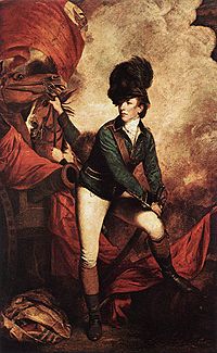 "Lieutenant-Colonel Banastre Tarleton" by Sir Joshua Reynolds
On July 17, 1781, British forces led by Banastre Tarleton and Tarleton's Raiders attacked Maney's Neck near Murfree's Landing. William Mufree's son, Hardy Murfree led a local militia that repulsed the attack at Skinner's Bridge.[4]
William Murfree contributed 97 acres (390,000 m2) of land surrounding Murfree's Landing in 1787 to the growing settlement to form a town. The town was chartered by the General Assmebly and renamed Murfreesboro on January 6, 1787.[4][6] This act also provided for the establishment of a public dock as the town was located at the northernmost point of navigation on the Meherrin river.[4]
Murfreesboro was designated by the US Congress in 1790 as an official port of entry, and the customs records indicate a profitable three-cornered trade with New England and the West Indies.[citation needed]
In 1809, the Hertford Academy was established in Murfreesboro and opened for business in 1811. In 1814, Harriet Sketchly and Martha Sketchly arrived and expanded the female department of the academy considerably so that by 1849, it became the Chowan Baptist Female Institute, the forerunner of Chowan University.[7]
In 1831 Murfreesboro sent armed forces led by Captain Solon Borland to Southampton County, Virginia to quell Nat Turner's slave rebellion.[8]
Education
Chowan University, a small Baptist university, is located in Murfreesboro. Local children may attend Riverview Elementary School and Hertford County Middle School, both of which are part of the Hertford County Public School system.
Commerce
Murfreesboro is no longer an active port. The last commercial vessel to operate on a regular basis was a Texaco Oil barge that ceased service to the town in October 1966.[4]
The town is served by the Roanoke-Chowan News-Herald Newspaper which is based in nearby Ahoskie.
Attractions
The old Murfreesboro public school (which housed grades 1 - 12 until 1972) has been remodeled into the Brady C. Jefcoat Museum housing the collections of Brady Jefcoat, a Raleigh, North Carolina native. It includes hundreds of well-preserved ordinary items from the late 19th and early 20th century, including functional phonographs, radios, washing machines, and agricultural implements, as well as a wide variety of other novelties.[9]
Entertainment
A different musical group performs on the first Saturday of each month at the auditorium behind the Brady C. Jefcoat Museum, and a public boat landing on the edge of town offers easy access to the Meherrin River, which in turn flows into the larger Chowan River a few miles downstream.
Highlights of town events include the annual North Carolina Watermelon Festival, the annual Roanoke-Chowan Pork-Fest barbecue competition held on the grounds of the Brady C. Jefcoat Museum each May, as well as July 4 fireworks celebration. There is also an annual all-night-long Relay For Life fundraiser festival each April. Each year in the few weeks before Christmas, a candlelit tour of historic homes in the town is conducted. There is also an annual Christmas parade featuring local businesses and churches.
Famous residents
- Curtis Deloatch, Carolina Panthers Cornerback[10]
- Richard Gatling, inventor of the machine gun, was born in the countryside north of Murfreesboro[citation needed]
- Khalid Sheikh Mohammed, an alleged Al Qaeda leader attended Chowan University in 1983.[11]
- Walter Reed was married in Murfreesboro[citation needed]
- William N. H. Smith, Democratic Congressman and North Carolina Supreme Court Justice
- John Hill Wheeler, the first US ambassador to Nicaragua and head of the US Mint in Charlotte, North Carolina was born in Murfreesboro on August 2, 1806.[4]
External links
- Murfressboro Historic Association
- Chowan University
- Brady C. Jefcoat Museum
- North Carolina Watermelon Festival
- Roanoke-Chowan Pork-Fest
- Meherrin Baptist Church
- Candelight Tour of Murfreesboro
- Murfreesboro Baptist Church
- Town of Murfreesboro
References
- ^ a b "American FactFinder". United States Census Bureau. http://factfinder.census.gov. Retrieved 2008-01-31.
- ^ "US Board on Geographic Names". United States Geological Survey. 2007-10-25. http://geonames.usgs.gov. Retrieved 2008-01-31.
- ^ "US Gazetteer files: 2010, 2000, and 1990". United States Census Bureau. 2011-02-12. http://www.census.gov/geo/www/gazetteer/gazette.html. Retrieved 2011-04-23.
- ^ a b c d e f g h i Stephenson, Frank E. Jr. (December 1986). Murfreesboro, North Carolina: 200 Years on the Meherrin River. Murfreesboro, North Carolina: Town of Murfreesboro. pp. 5–9.
- ^ Parramore, Thomas C. (1969). The Ancient Maritime Village of Murfreesborough: 1787-1825. Murfreesboro, North Carolinia: Johnson Publishing Company. pp. 11. ISBN 0930230027. http://books.google.com/?id=boZKAAAAMAAJ.
- ^ Parramore, Thomas C. (2001). Murfreesboro, North Carolina and the Founding of the American Republic 1608-1871. Murfreesboro, North Carolina: Murfreesboro Historicall Association, Inc.. pp. 1.
- ^ Dr. Thomas C., Parramore (1969). The Ancient Maritime Village of Murfreesborough: 1787-1825. Murfreesboro, North Carolinia: Johnson Publishing Company. pp. 52, 69. ISBN 0930230027. http://books.google.com/?id=boZKAAAAMAAJ.
- ^ Parramore, Dr. Thomas C. (1998). Trial Separation: Murfreesboro, North Carolina and the Civil War. Murfreesboro, North Carolinia: Murfreesboro Historical Association, Inc.. pp. 10. LCCN TX-5-007-748.
- ^ "The Brady C. Jefcoat Museum". Murfreesboro Historical Association. 2007. Archived from the original on 2008-01-31. http://web.archive.org/web/20080131025131/http://www.murfreesboronc.org/venuespages/jefcoat.html. Retrieved 2007-12-27.
- ^ "Curtis Deloatch". Carolina Panthers. NFL Enterprises LLC. 2007. http://www.nfl.com/players/curtisdeloatch/profile?id=DEL553412. Retrieved 2007-12-27.
- ^ Eggen, Dan (July 27, 2004). "9/11 Report Says Plotter Saw Self as Superterrorist". Washington Post: pp. A1. http://www.washingtonpost.com/ac2/wp-dyn/A16232-2004Jul26
Municipalities and communities of Hertford County, North Carolina Towns Ahoskie | Como | Harrellsville | Murfreesboro | Winton

Village Townships Ahoskie | Cofield | Como | Harrellsville | Murfreesboro | St. Johns | Winton
Categories:- Populated places established in 1787
- Populated places in Hertford County, North Carolina
- Towns in North Carolina


Wikimedia Foundation. 2010.