Crane Creek Regional Park
- Crane Creek Regional Park
-
Crane Creek Regional Park is a regional park east of Rohnert Park, California, U.S.A. which is maintained by the Sonoma County Regional Parks Department. It covers an area of 128 acres (52 ha)[1] at 38°20′46″N 122°38′42″W / 38.346°N 122.645°W / 38.346; -122.645[2]Coordinates: 38°20′46″N 122°38′42″W / 38.346°N 122.645°W / 38.346; -122.645[2]. The park entrance is at 6107 Pressley Road.
Facilities and features
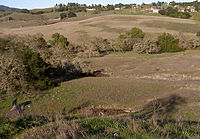
View of meadow and creek at Crane Creek Regional Park
The park features numerous unpaved trails suitable for hiking, including:
- Creek Trail
- Hawk Ridge Trail
- Lupine Trail
- Poppy Trail
- Sunset Trail
There is also a loop trail (Fiddleneck Trail, Buckeye Trail, Northern Look Trail) suitable for bicycling or horseback riding. There are picnic tables and latrines near the parking area. Crane Creek flows through the park from southeast to northwest.
History
The land, originally homesteaded by Robert Crane in 1852, was purchased by the county in 1975 using grant money from Land and Water Conservation Funds. A botanical study performed in 1991 found significant damage to the wildflower meadows. This finding resulted in the exclusion of bicycles and horses from the meadow areas.[1]
See also
References
External links
Categories:
- Parks in Sonoma County, California
- Regional parks in California
Wikimedia Foundation.
2010.
Look at other dictionaries:
Crane Creek (California) — Coordinates: 38°21′19″N 122°41′26″W / 38.35528°N 122.69056°W / 38.35528; 122.69056 … Wikipedia
Caesar Creek State Park — Location Warren / Clinton / Greene counties, Ohio, USA Nearest city Waynesville, Ohio … Wikipedia
Copeland Creek — Coordinates: 38°20′37″N 122°43′25″W / 38.34361°N 122.72361°W / 38.34361; 122.72361 … Wikipedia
List of county and regional parks in Minnesota — Aitkin County= *Aitkin Campground *Berglund Park *Jacobson Campground *Jacobson Wayside Rest *Snake River Campground =Anoka County= [http://www.anokacountyparks.com Official site] *Anoka County Riverfront Regional Park *Bunker Hills Regional Park … Wikipedia
Regional vocabularies of American English — vary. Below is a list of lexical differences in vocabulary that are generally associated with a region. A term featured on a list may or may not be found throughout the region concerned, and may or may be not recognized by speakers outside of… … Wikipedia
Rohnert Park, California — Infobox Settlement official name = City of Rohnert Park other name = native name = nickname = settlement type = City motto = imagesize = image caption = flag size = image seal size = image shield = shield size = image blank emblem =… … Wikipedia
Cuyahoga Valley National Park — IUCN Category II (National Park) Bedrock outcrops, such as this one, can be found throughout the park … Wikipedia
Cowan Lake State Park — For the Pennsylvania State Park, see Cowans Gap State Park. Cowan Lake State Park Ohio State Park Natural Monument (IUCN III) … Wikipedia
Hopewell Culture National Historical Park — 1840s map of Mound City … Wikipedia
Dayton Aviation Heritage National Historical Park — IUCN Category V (Protected Landscape/Seascape) … Wikipedia

