- Nogmung
-
Nogmung
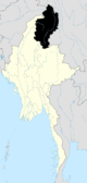
နောင်မွန်းမြို့Location in Burma
 Nogmung
Coordinates: 27°30′0″N 97°49′0″E / 27.5°N 97.816667°ECoordinates: 27°30′0″N 97°49′0″E / 27.5°N 97.816667°E Country  Burma
BurmaDivision Kachin State District Putao District Township Nogmung Township Government – Mayor Population (2005) – Religions Buddhism Time zone MST (UTC+6.30) Nogmung (Burmese: နောင်မွန်းမြို့); sometimes Naung Mung or Naun Mong and combinations) is a town of about 1000 inhabitants (2006) in northern Kachin State (Myanmar, the former Burma). It is the last town encountered when hiking northwards to the Hkakabo Razi National Park and the highest peak of Myanmar, Mt. Hkakabo Razi. Nogmung is also the gateway for Tahaundam, the northernmost village of Myanmar. Nogmung is famous for its birds, and many endemic species are postulated to exist there. Most recently the Naung Mung Scimitar-babbler (Jabouilleia naungmungensis) was described.[1] The Smithsonian's National Zoo and the Hkakabo Razi National Park Authorities have surveyed the avifauna since 2001 in Putao, Nogmung, and northwards to Tahaundam.[2]
References
- ^ John H. Rappole, Swen C. Renner, Nay Myo Shwe, Paul R. Sweet. 2005. A New Species of Scimitar-Babbler (Timalidae: Jabouilleia) From the Sub-Himalayan Region of Myanmar. The Auk 122:1064-1069
- ^ Swen C. Renner, John H. Rappole, Peter Leimgruber, Daniel S. Kelly, Nay Myo Shwe, Thein Aung, Myint Aung. 2007. Land cover in the Northern Forest Complex of Myanmar: new insights for conservation. Oryx 41:27-37
External links
Kachin State Capital: MyitkyinaMyitkyina District 
Bhamo District Putao District Mohnyin District Main cities and towns Categories:- Township capitals of Burma
- Populated places in Kachin State


Wikimedia Foundation. 2010.