- Onondaga, New York
-
Onondaga, New York — Town — Location within the state of New York
 Onondaga, New York
Coordinates: 42°58′41″N 76°11′54″W / 42.97806°N 76.19833°WCoordinates: 42°58′41″N 76°11′54″W / 42.97806°N 76.19833°W Country United States State New York County Onondaga Government – Type Town Council – Town Supervisor Thomas P. Andino, Jr. (R) – Town Council Members' ListArea – Total 57.8 sq mi (149.8 km2) – Land 57.7 sq mi (149.5 km2) – Water 0.1 sq mi (0.2 km2) Elevation 1,033 ft (315 m) Population (2000) – Total 21,063 – Density 364.9/sq mi (140.9/km2) Time zone Eastern (EST) (UTC-5) – Summer (DST) EDT (UTC-4) ZIP code 13207 Area code(s) 315 FIPS code 36-54958 GNIS feature ID 0979311  An upscale neighborhood in the hills of the Town of Onondaga just outside Syracuse, NY.
Onondaga is a town located in Onondaga County, New York, United States. As of the 2000 U.S. Census, the town had a population of 21,063. The town is named after the native Onondaga tribe, part of the Iroquois Confederacy.
The Town of Onondaga is located southwest of the City of Syracuse, which it borders.
Contents
History
Native Americans have inhabited the region for centuries. As early as 1600, Onondaga was a village that served as the capital of the Iroquois League and the primary settlement of the Onondaga people. During the American Revolutionary War, the Onondagas sided with the British, and Onondaga was attacked by the Continental Army on April 21, 1779. After the war, the Onondagas were forced to cede their lands in New York to the new state, although some land was set aside to form the Onondaga Reservation. Most of the Onondagas left New York and were resettled in Upper Canada.
The Onondaga region was within what was designated the Central New York Military Tract, in which the new government allotted land grants to veterans as payment for their war service. In the postwar years, the area was flooded with migrants from New England and eastern New York. The Town of Onondaga was incorporated on April 2, 1798 from parts of other towns, with several subsequent boundary changes. When Onondaga County was formed in 1794, the town was established originally from parts of the Towns of Marcellus, Pompey, and Manlius.
The first court house for the County of Onondaga was built in 1805 on the public square in Onondaga Hill, which was then the county seat. The building was laid out by surveyor and engineer James Geddes (see Town of Geddes). After the county seat was moved to Syracuse in 1830, the building in Onondaga Hill was used as a school until 1846.
The Gen. Orrin Hutchinson House on Seneca Turnpike is the only Town of Onondaga site listed in the National Register of Historic Places.
Geography
According to the United States Census Bureau, the town has a total area of 57.8 square miles (150 km2), of which, 57.7 square miles (149 km2) of it is land and 0.1 square miles (0.26 km2) of it (0.16%) is water.
Interstate 81 passes along the east side of the town. US Route 11 is a north-south highway in the eastern part of Onondaga, paralleling the interstate. US Route 20 is an east-west highway in the south of the town. New York State Route 173 is an east-west highway through the middle of Onondaga. New York State Route 11A diverges westward from US-11. New York State Route 80 cuts through the south part of the town.
Demographics
 A Town of Onondaga neighborhood overlooking the City of Syracuse
As of the census[1] of 2000, there were 21,063 people, 7,679 households, and 5,513 families residing in the town. The population density was 364.9 people per square mile (140.9/km²). There were 7,964 housing units at an average density of 138.0 per square mile (53.3/km²). The racial makeup of the town was 94.29% White, 1.96% African American, 1.07% Native American, 1.16% Asian, 0.04% Pacific Islander, 0.16% from other races, and 1.32% from two or more races. Hispanic or Latino of any race were 1.05% of the population.
There were 7,679 households out of which 35.1% had children under the age of 18 living with them, 60.4% were married couples living together, 8.1% had a female householder with no husband present, and 28.2% were non-families. 23.5% of all households were made up of individuals and 11.2% had someone living alone who was 65 years of age or older. The average household size was 2.64 and the average family size was 3.15.
In the town the population was spread out with 26.5% under the age of 18, 5.4% from 18 to 24, 27.2% from 25 to 44, 23.7% from 45 to 64, and 17.2% who were 65 years of age or older. The median age was 40 years. For every 100 females there were 92.0 males. For every 100 females age 18 and over, there were 86.7 males.
The median income for a household in the town was $53,421, and the median income for a family was $63,674. Males had a median income of $42,495 versus $31,160 for females. The per capita income for the town was $25,522. About 2.6% of families and 4.2% of the population were below the poverty line, including 3.8% of those under age 18 and 6.7% of those age 65 or over.
Communities and locations in Onondaga
There are no villages in the Town of Onondaga. The following is a complete list of the town's hamlets as listed in the New York Gazetteer,[2] as well as other localities of interest:
- Cards Corners – A populated place on NY-175 near the west town line.
- Cedarvale – A hamlet near the west town line.
- Five Corners – A location between Navarino and Joshua on US-20.
- Griffin's Corners – A populated place east of South Onondaga.
- Gwilt's Corners – A populated place
- Howlett Hill-- A hamlet in the northwest part of Onondaga, west of Kellys Corners.
- Indian Village – A hamlet within the Onondaga Nation Reservation on NY-11A.
- Ironsides – A populated place south of South Onondaga by the south town line.
- Joshua – A populated place on US-20 in the southwest part of the town.
- Kellys Corners – A populated place in the northwest part of Onondaga.
- Loomis Hill – A populated place in the north-west part of Onondaga.
- Lord's Corners – A hamlet on US-20 in the south part of the town.
- Navarino – A hamlet in the southwest corner of the town.
- Nedrow – A hamlet on US-11 near Interstate 81.
- Nichols' Corners – A hamlet northwest of South Onondaga.
- Onondaga Castle – A hamlet at the junction of US-11 and NY-11A in the east part of the town, south of Nedrow.
- Onondaga Hill – A hamlet on NY-173 near the center of Onondaga.
- Onondaga Nation Reservation – A Native American reservation partly in the town, considered by the natives to be autonomous of other jurisdictions.
- Pumpkin Hollow – A valley at the west town line.
- Sentinel Heights – A populated place near the east town line, southeast of Nedrow.
- South Onondaga – A hamlet in the south part of the town.
- Southwood – A hamlet near the east town line on NY-173.
- Split Rock – A hamlet near the north town line.
- Taunton – A hamlet near the north town line.
- Wellington Corner – A populated place near the west town line, west of Cards Corners.
Notes
- ^ "American FactFinder". United States Census Bureau. http://factfinder.census.gov. Retrieved 2008-01-31.
- ^ New York State Gazetteer. Albany, NY: New York State Department of Health. 1995. Available at New York State Library Digital Image Project. Note: While the New York State Gazetteer lists Onondaga Valley as a hamlet in Onondaga, it in fact was annexed to Syracuse in 1926. Source: "Welcome to the Valley", pamphlet published by City of Syracuse, August 2006.
External links
- Town of Onondaga, NY
- The Town of Onondaga Historical Society
- Summary history of the Town of Onondaga
- Genealogy/history of Onondaga
Municipalities and communities of Onondaga County, New York City 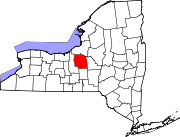
Towns Villages Baldwinsville | Camillus | East Syracuse | Elbridge | Fabius | Fayetteville | Jordan | Liverpool | Manlius | Marcellus | Minoa | North Syracuse | Skaneateles | Solvay | Tully
CDPs Brewerton‡ | Bridgeport‡ | Fairmount | Galeville | Lakeland | Lyncourt | Mattydale | Nedrow | Seneca Knolls | Village Green | Westvale
Other
hamletsAmber | Amboy | Apulia | Apulia Station | Borodino | Cardiff | Cedarvale | Clintonville | Collingwood | Delphi | Delphi Falls | Geddes | Hart Lot | Hinsdale | Howlett Hill | Indian Village | Jack's Reef | Jamesville | Long Branch | Marietta | Memphis | Messina Springs | Mottville | Mycenae | Navarino | Onondaga Hill | Oran | Otisco | Plainville | Pompey Center | Rose Hill | Shepard Settlement | Skaneateles Falls | South Onondaga | South Spafford | Southwood | Spafford Valley | Split Rock | State Fair Grounds | Taunton | Thorn Hill | Vesper | Warners | Watervale
Indian
reservationFootnotes ‡This populated place also has portions in an adjacent county or counties
Categories:- Towns in New York
- Syracuse metropolitan area
- Populated places in Onondaga County, New York
- Place names in New York of Native American origin


Wikimedia Foundation. 2010.