- East Windsor Township, New Jersey
-
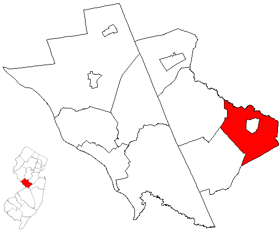
East Windsor Township, New Jersey — Township — East Windsor Township highlighted in Mercer County. Inset map: Mercer County highlighted in the State of New Jersey. Census Bureau map of East Windsor Township, New Jersey
Coordinates: 40°16′8″N 74°32′15″W / 40.26889°N 74.5375°WCoordinates: 40°16′8″N 74°32′15″W / 40.26889°N 74.5375°W Country United States State New Jersey County Mercer Formed February 9, 1797 Incorporated February 21, 1798 Government[1] – Type Faulkner Act (Council-Manager) – Mayor Janice S. Mironov Area – Total 15.7 sq mi (40.7 km2) – Land 15.6 sq mi (40.5 km2) – Water 0.1 sq mi (0.1 km2) Elevation[2] 121 ft (37 m) Population (2010) – Total 27,190 – Density 1,742.9/sq mi (671.4/km2) Time zone Eastern (EST) (UTC-5) – Summer (DST) EDT (UTC-4) ZIP code 08520 Area code(s) 609 FIPS code 34-19780[3][4] GNIS feature ID 0882123[5] Website http://www.east-windsor.nj.us East Windsor Township is a Township in Mercer County, New Jersey, United States. As of the 2010 United States Census, the township population was 27,190.
East Windsor Township was formed when Windsor Township was split on February 9, 1797, with West Windsor Township formed at the same time, all while the area was still part of Middlesex County. It was incorporated as one of New Jersey's initial group of 104 townships by an Act of the New Jersey Legislature on February 21, 1798. Portions of the township were taken to form Hightstown borough (March 5, 1853, within East Windsor; became independent c. 1894) and Robbinsville Township (March 11, 1860, and known as Washington Township until 2007).[6]
Contents
Geography
According to the United States Census Bureau, the township has a total area of 15.7 square miles (41 km2), of which, 15.6 square miles (40 km2) of it is land and 0.1 square miles (0.26 km2) of it (0.32%) is water.
Twin Rivers (2000 Census population of 7,422) is a census-designated place and unincorporated area located within East Windsor Township.

Plainsboro Twp Cranbury Twp Monroe Township West Windsor Twp 
 East Windsor Township

Robbinsville Township Upper Freehold Township Millstone Township Also: East Windsor surrounds Hightstown.
Demographics
Historical populations Census Pop. %± 1930 922 — 1940 845 −8.4% 1950 1,284 52.0% 1960 2,298 79.0% 1970 11,736 410.7% 1980 21,041 79.3% 1990 22,353 6.2% 2000 24,919 11.5% 2010 27,190 9.1% Population 1930 - 1990.[7] As of the census[3] of 2000, there were 24,919 people, 9,448 households, and 6,556 families residing in the township. The population density was 1,592.8 people per square mile (614.8/km²). There were 9,880 housing units at an average density of 631.5 per square mile (243.8/km²). The racial makeup of the township was 74.42% White, 8.90% African American, 0.20% Native American, 9.55% Asian, 0.12% Pacific Islander, 4.61% from other races, and 2.20% from two or more races. Hispanic or Latino of any race were 14.28% of the population. However, there is a significant population of undocumented Hispanic immigrants in the thousands which is not captured by census counts.[citation needed] School studies show that up to 20% of the total population in the school system is made up of undocumented immigrants.[citation needed]
There were 9,448 households out of which 34.2% had children under the age of 18 living with them, 55.6% were married couples living together, 9.6% had a female householder with no husband present, and 30.6% were non-families. 24.6% of all households were made up of individuals and 6.6% had someone living alone who was 65 years of age or older. The average household size was 2.61 and the average family size was 3.12.
The population of the township was spread out with 24.0% under the age of 18, 7.6% from 18 to 24, 35.2% from 25 to 44, 24.9% from 45 to 64, and 8.3% who were 65 years of age or older. The median age was 36 years. For every 100 females there were 95.2 males. For every 100 females age 18 and over, there were 91.6 males.
The median income for a household in the township was $63,616, and the median income for a family was $73,461. Males had a median income of $50,875 versus $35,260 for females. The per capita income for the township was $28,695. About 2.8% of families and 5.3% of the population were below the poverty line, including 4.3% of those under age 18 and 8.1% of those age 65 or over.
Transportation
East Windsor has a few bus stops. The line which runs through East Windsor proceeds to stop in Monroe, and then makes its way to the Port Authority Bus Terminal.
A number of county routes, such as CR 539, 571, 535 pass through the township. Route 33 goes through East Windsor, and then through Robbinsville Township and Monroe Township. U.S. Route 130 also goes through East Windsor which then goes through Robbinsville and Cranbury. Interstate 195 is outside the municipality in neighboring Robbinsville, Upper Freehold, and Millstone Townships.
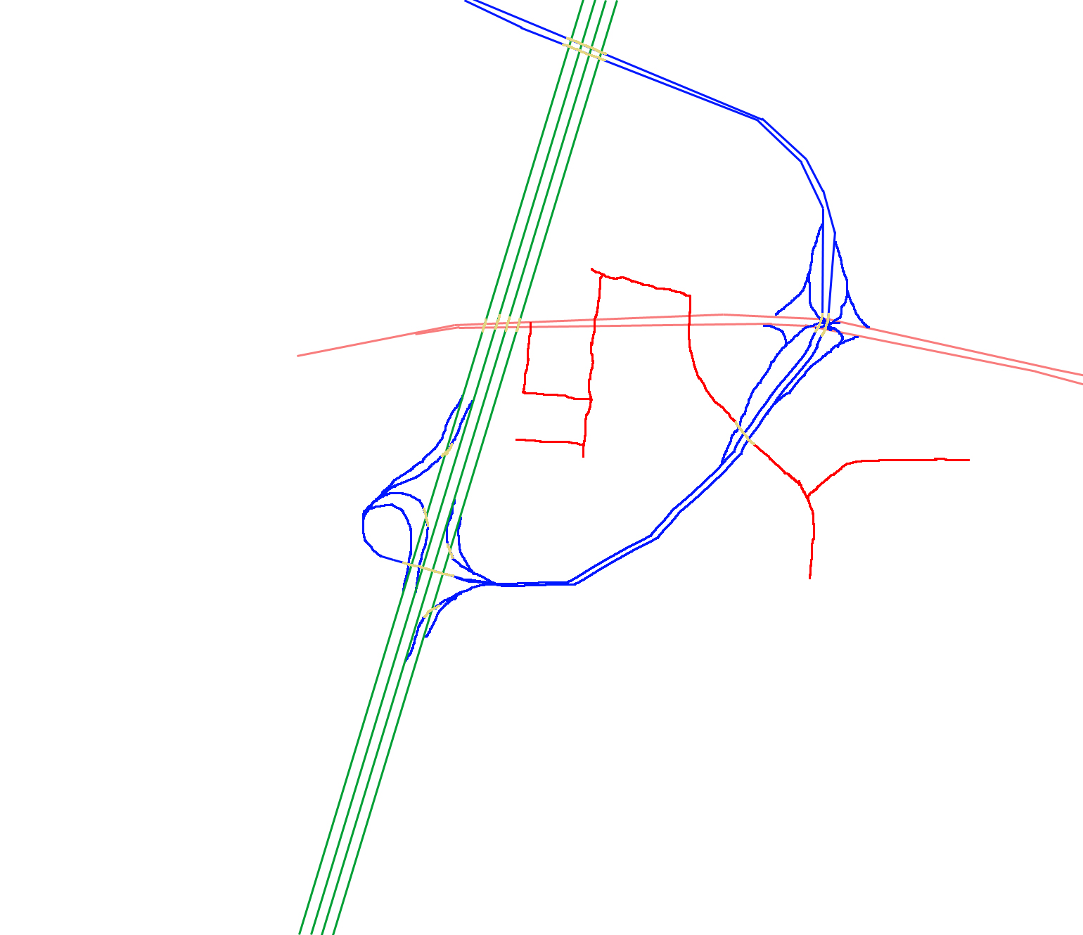
In the late 1990s, the "Hightstown Bypass" (Route 133) was constructed. It starts at County Route 571 and terminates at 33. The entire highway is in East Windsor; there is a half-diamond interchange with One Mile Road, and a three-quarter cloverleaf interchange with U.S. Route 130. Both ends of the bypass are handled with traffic signals instead of grade separated interchanges. The township also houses a 5-lane toll gate for Exit 8 of the New Jersey Turnpike (Interstate 95).
At the present time, the Turnpike is being widened from three lanes to a six-lane turnpike. This is part of a major widening project that would extend the "dual-dual" roadways to Exit 6 (Mansfield Township) from its current end at Exit 8A (Monroe Township). This project is anticipated to be finished by 2014.
On January 1, 2007, the New Jersey Turnpike Authority announced its plans for Exit 8. Prior to this plan being released, some thought that a new Exit 8 would connect directly with the Hightstown Bypass. There seems to be ample space (between mile markers 67.89 and 68.12) to build a new interchange because there's a large piece of land that would accommodate a toll gate and interchange ramps for 133. The plan that was released indicated that the current Interchange 8 will be demolished and replaced with a new interchange which would end at the intersection with Route 33, Milford Road, and the Hightstown Bypass (on the east side of the expressway in lieu of the west). It would also grant direct access to the bypass (without going through any traffic lights), as well as to 33 using a grade separated interchange. The new toll gate would also feature a total of 12 lanes at the gate. However, the interchange and the toll gate would run near some residential houses located right off of 33, and would disturb Twin Rivers. The Authority released 3 configuration options at the intersection of Milford, 33, and the bypass.
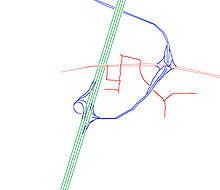 Option 1
- Option 1: This option would feature turnpike ramps that would lead to a diamond interchange at Route 33, while the turnpike ramp turns into the 133 bypass and would cross over Route 33. At the intersection with 33 and the interchange ramps (from the turnpike and 133), a traffic signal would be built underneath Exit 8/Route 133. However, the drawback is that this option would “stop drivers from making several turns near the exit. These include left-hand turns from Route 33 onto [a relocated] Milford Road and from Milford Road onto Route 33.” To make turns that are restricted, “the plan would push some trucks headed for Milford Road onto Lake Drive, which would be connected to Milford by a new connector road.” The relocated Milford Road would start at the intersection of Monmouth Street and continue southeast to the existing Milford Road near Daniel Street.
- Option 2: A grade-separated diamond interchange would be constructed, which would lead the ramps towards Route 33. At the intersection with Route 33 and the interchange ramps (from the turnpike and 133), a traffic signal would be built underneath Exit 8 ramps/Route 133. In lieu of a connector road, a jug handle would be built on 33 west. This would intersect at 33 (with a traffic light) and become the relocated Milford Road (after crossing 33). The road would cross over the Turnpike ramps and resume its course near Daniel Street.
- Option 3: A modified cloverleaf interchange would be built in lieu of a diamond interchange. After exiting the turnpike from the 8 toll gate, a ramp on the right would lead to Milford Road or Route 33. The mainline of the turnpike ramp would cross over 33 and turn into the 133 bypass. A relocated Milford Road would be built across from Monmouth Street & 33 (without connecting Monmouth and Milford) towards the intersection with the current Milford Road and Daniel Street. The new Milford would cross over the turnpike ramps. A leaf would be built from the turnpike ramp approaching the 8 toll gate, which would connect to Milford. An entrance ramp would be constructed from Milford Road to the 8 toll gate. Traveling north on Milford, a ramp would be constructed, which would diverge into 2 ways; one way would merge into the turnpike ramp heading towards 133, and the other would intersect at a new traffic light at Route 33 (just 1/10 mile east of the current 33-133-Milford intersection).[8]
Government
Local government
East Windsor Township has a Council-Manager form of government as provided under the Faulkner Act. The Council is made up of seven members elected at large for four-year staggered terms. Elections for Council are held in November of every other year.[1]
Members of the East Windsor Township Council are Mayor Janice S. Mironov, Deputy Mayor Perry M. Shapiro, Walter T. Daniels, Hector Duke, Marc Lippman, Alan Rosenberg and Marsha Weinstein.[9]
Citizens of East Windsor are served by East Windsor Rescue Squad Districts I & II, as well as East Windsor volunteer Fire Departments #1 and 2. The Township is split for faster response times, with Rescue Squad District II and Fire Department 2 serving Twin Rivers and the Eastern portion of the Township.
The East Windsor Police Department, Located on One Mile Road, is led by Police Chief William Spain, and employs 37 Uniformed Patrol and Traffic Enforcement Officers, 9 Detectives, 7 Dispatchers and Communications Officers and one Animal Control Officer, for a total of 47 Sworn Police Officers.
Federal, state and county representation
East Windsor Township is in the 4th Congressional district. New Jersey's Fourth Congressional District is represented by Christopher Smith (R). New Jersey is represented in the United States Senate by Frank Lautenberg (D, Cliffside Park) and Bob Menendez (D, Hoboken).
East Windsor Township is in the 12th legislative district of the New Jersey Legislature, which is represented in the New Jersey Senate by Jennifer Beck (R, Red Bank) and in the New Jersey General Assembly by Caroline Casagrande (R, Colts Neck Township) and Declan O'Scanlon (R, Little Silver).[10]
Under Mercer County's form of government, the County Executive performs executive functions and oversees the day-to-day operations of the county and a seven-member Board of Chosen Freeholders acts in a legislative capacity, setting policy. As of 2011, the County Executive is Brian M. Hughes.[11] Members of the Board of Chosen Freeholders are elected at-large to serve three-year terms on a staggered basis, with two or three seats coming up for election each year. A Freeholder Chair and Vice-Chair are selected on an annual basis from among its members.[12] County Freeholders are Freeholder Chair Pasqual "Pat" Colavita, Jr. (term ends December 31, 2012; Lawrenceville)[13], Freeholder Vice Chair Lucylle R. S. Walter (2011; Ewing Township)[14], Samuel T. Frisby (2011; Trenton)[15], Ann M. Cannon (2012; East Windsor Township)[16], Anthony P. Carabelli (2013; Trenton)[17], John Cimino (2011; Hamilton Township)[18] and Andrew Koontz (2013; Princeton Borough)[19][20]
Education
Students in Kindergarten through 12th grade attend the East Windsor Regional School District, a comprehensive public school district serving students from East Windsor Township and Hightstown Borough, along with students in grades 7 - 12 from Roosevelt Borough as part of a sending / receiving relationship.[21]
The district has four K-5 elementary schools — Walter C. Black Elementary School with 581 students, Perry L. Drew Elementary School with 692 students, Ethel McKnight Elementary School with 572 students, Grace N. Rogers Elementary School with 502 students — Melvin H. Kreps School grades 6 - 8 with 1,139 students and Hightstown High School with 1,370 students in grades 9 - 12.
Other
The Meadow Lakes continuing care retirement community occupies a 100-acre site that spans the East Windsor-Hightstown boundary line.
Notable residents
Notable current and former residents of East Windsor Township include:
- Clara Barton (1821–1912), founder of the American Red Cross, taught at the Cedarville Road School in East Windsor 1851-2.[22]
- Lisa P. Jackson (born 1962), Administrator of the Environmental Protection Agency (EPA).[23]
- Marlon LeBlanc, Head Men's Soccer Coach at West Virginia University.[24]
- Tony Paige (boxing) (born 1953), radio talk show host on WFAN.[25]
- Anton Strout (born 1970), urban fantasy novelist.[26]
References
- ^ a b 2005 New Jersey Legislative District Data Book, Rutgers University Edward J. Bloustein School of Planning and Public Policy, April 2005, p. 63.
- ^ U.S. Geological Survey Geographic Names Information System: Township of East Windsor, Geographic Names Information System. Accessed June 13, 2008.
- ^ a b "American FactFinder". United States Census Bureau. http://factfinder.census.gov. Retrieved 2008-01-31.
- ^ A Cure for the Common Codes: New Jersey, Missouri Census Data Center. Accessed July 14, 2008.
- ^ "US Board on Geographic Names". United States Geological Survey. 2007-10-25. http://geonames.usgs.gov. Retrieved 2008-01-31.
- ^ "The Story of New Jersey's Civil Boundaries: 1606-1968", John P. Snyder, Bureau of Geology and Topography; Trenton, New Jersey; 1969. p. 161.
- ^ New Jersey Resident Population by Municipality: 1930 - 1990, Workforce New Jersey Public Information Network. Accessed March 1, 2007.
- ^ Pike plan raises concern, The Trenton Times, January 1, 2007.
- ^ East Windsor Township Mayor & Council, East Windsor Township. Accessed July 9, 2008.
- ^ "Legislative Roster: 2010-2011 Session". New Jersey Legislature. http://www.njleg.state.nj.us/members/roster.asp. Retrieved 2010-02-08.
- ^ County Executive, Mercer County, New Jersey. Accessed January 5, 2011.
- ^ What is a Freeholder?, Mercer County, New Jersey. Accessed January 5, 2011.
- ^ Pasquale "Pat" Colavita, Jr., Mercer County. Accessed January 6, 2011.
- ^ Lucylle R. S. Walter, Mercer County. Accessed January 6, 2011.
- ^ Samuel T. Frisby, Mercer County. Accessed August 1, 2011.
- ^ Ann M. Cannon, Mercer County. Accessed January 6, 2011.
- ^ Anthony P. Carabelli, Mercer County. Accessed January 6, 2011.
- ^ John Cimino, Mercer County. Accessed January 6, 2011.
- ^ Andrew Koontz, Mercer County. Accessed January 6, 2011.
- ^ Meet the Freeholders, Mercer County. Accessed January 6, 2011.
- ^ East Windsor Regional School District 2007 Report Card Narrative, New Jersey Department of Education. Accessed April 15, 2008. "The East Windsor Regional School District, located in central New Jersey at New Jersey Turnpike Exit 8, is a growing K-12 public school district serving the communities of the East Windsor Township and the Borough of Hightstown as well as Roosevelt Borough students grades 7 through 12."
- ^ Brennan, P.S and Brennan, F. J. Jr. Images of America: Hightstown and East Windsor, Arcadia Publishing, Dover NH, 1996. ISBN 0-7524-0516-0.
- ^ About Commissioner Lisa P. Jackson, New Jersey Department of Environmental Protection. Accessed December 18, 2006.
- ^ Men's Soccer Coaching Staff: Marlon LeBlanc - Head Coach, West Virginia Mountaineers. Accessed July 9, 2008. "The East Windsor, N.J., native holds the national, advanced national and premier coaching diplomas with a “Distinguished Pass” from the NSCAA."
- ^ Tony Paige, WFAN. Accessed June 6, 2011. "Paige is married to the former Terilyn Smith of Bermuda and they reside in East Windsor, New Jersey with their son Jalen."
- ^ Anton Strout (2008-09-13). "Anton Strout's biography". antonstrout.com. http://www.antonstrout.com/Ant-ology.html.
External links
- East Windsor Township web site
- East Windsor Regional School District
- East Windsor Regional School District's 2009–10 School Report Card from the New Jersey Department of Education
- Data for the East Windsor Regional School District, National Center for Education Statistics
- East Windsor Fire Company #1
- East Windsor Fire Company #2
- East Windsor Police Department
- East Windsor Township Rescue Squad, District I
- East Windsor Township Rescue Squad, District II
Municipalities and communities of Mercer County, New Jersey City 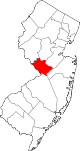
Boroughs Townships East Windsor | Ewing | Hamilton | Hopewell | Lawrence | Princeton | Robbinsville | West Windsor
CDPs Communities Etra | Grover's Mill | Hamilton Square | Kingston | Mount Rose | Titusville | Windsor
Categories:- Faulkner Act Council-Manager
- Townships in Mercer County, New Jersey


Wikimedia Foundation. 2010.