- Deering, New Hampshire
-
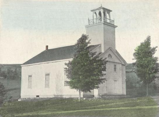
Deering, New Hampshire — Town — Deering Community Church, built 1829

SealLocation in Hillsborough County, New Hampshire
Coordinates: 43°04′23″N 71°50′40″W / 43.07306°N 71.84444°WCoordinates: 43°04′23″N 71°50′40″W / 43.07306°N 71.84444°W Country United States State New Hampshire County Hillsborough Incorporated 1774 Government – Board of Selectmen J.P. Marzullo
Michelle Johnson
John GreeneArea – Total 31.4 sq mi (81.4 km2) – Land 30.8 sq mi (79.8 km2) – Water 0.6 sq mi (1.7 km2) 2.04% Elevation 1,083 ft (330 m) Population (2010) – Total 1,912 – Density 60.9/sq mi (23.5/km2) Time zone Eastern (UTC-5) – Summer (DST) Eastern (UTC-4) ZIP code 03244 Area code(s) 603 FIPS code 33-17780 GNIS feature ID 0873577 Website www.deering.nh.us Deering is a town in Hillsborough County, New Hampshire, United States. The population was 1,912 at the 2010 census.[1]
Contents
History
First settled about 1765, the town was incorporated on January 17, 1774 by John Wentworth, governor of the province of New Hampshire. He named it Deering after the maiden name of his wife, Frances Deering Wentworth, just as two years earlier he bestowed Francestown with her first name. Deering had 928 residents when the first census was taken in 1790. By 1859, the population was 890. Its hills and valleys were well suited for agriculture. Industries included two sawmills, one gristmill, and one clothing factory.[2]
Notable inhabitants
- James W. Grimes, U.S. senator and governor of Iowa
- Lotte Jacobi, photographer, made Deering her home from 1955 until her death in 1990
- Ebenezer Locke (1735–1816) of Woburn, Massachusetts, reputed to have fired the famous shot heard 'round the world (the first shot fired by an American at the Battle of Lexington). Locke spent his later years in Deering and is buried here.[3]
- Jon Rheault (born August 1, 1986), professional ice hockey player currently with the Abbotsford Heat in the American Hockey League
- Tom Rush, folk singer, lived from 1971 to 1990 in Deering, where his former estate is now Tom Rush Forest
Geography
According to the United States Census Bureau, the town has a total area of 31.4 square miles (81 km2), of which 30.8 sq mi (80 km2) is land and 0.6 sq mi (1.6 km2) is water, comprising 2.04% of the town. The highest point in Deering is Clark Summit, at 1,570 feet (480 m) above sea level. Deering lies fully within the Merrimack River watershed.[4]
The town is crossed by State Route 149.
Demographics
As of the census[5] of 2000, there were 1,875 people, 713 households, and 518 families residing in the town. The population density was 60.9 people per square mile (23.5/km²). There were 933 housing units at an average density of 30.3 per square mile (11.7/km²). The racial makeup of the town was 98.45% White, 0.27% African American, 0.11% Native American, 0.05% Pacific Islander, 0.21% from other races, and 0.91% from two or more races. Hispanic or Latino of any race were 1.07% of the population.
There were 713 households out of which 34.4% had children under the age of 18 living with them, 61.3% were married couples living together, 7.0% had a female householder with no husband present, and 27.3% were non-families. 22.9% of all households were made up of individuals and 9.4% had someone living alone who was 65 years of age or older. The average household size was 2.52 and the average family size was 2.95.
In the town the population was spread out with 26.1% under the age of 18, 6.0% from 18 to 24, 30.2% from 25 to 44, 27.0% from 45 to 64, and 10.7% who were 65 years of age or older. The median age was 39 years. For every 100 females there were 102.0 males. For every 100 females age 18 and over, there were 99.1 males.
The median income for a household in the town was $48,750, and the median income for a family was $53,889. Males had a median income of $35,813 versus $26,144 for females. The per capita income for the town was $20,856. About 1.2% of families and 4.0% of the population were below the poverty line, including 1.9% of those under age 18 and 5.0% of those age 65 or over.
References
- ^ United States Census Bureau, American FactFinder, 2010 Census figures. Retrieved March 23, 2011.
- ^ Austin J. Coolidge & John B. Mansfield, A History and Description of New England, Boston, Massachusetts 1859
- ^ William Poole (February 2001). "Ebenezer Locke". The Lexington Minute Men. http://www.lexingtonminutemen.com/EbenLocke.html. Retrieved June 6, 2011.
- ^ Foster, Debra H.; Batorfalvy, Tatianna N.; and Medalie, Laura (1995). Water Use in New Hampshire: An Activities Guide for Teachers. U.S. Department of the Interior and U.S. Geological Survey. http://nh.water.usgs.gov/Publications/nh.intro.html.
- ^ "American FactFinder". United States Census Bureau. http://factfinder.census.gov. Retrieved 2008-01-31.
External links
Municipalities and communities of Hillsborough County, New Hampshire Cities 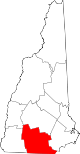
Towns Amherst | Antrim | Bedford | Bennington | Brookline | Deering | Francestown | Goffstown | Greenfield | Greenville | Hancock | Hillsborough | Hollis | Hudson | Litchfield | Lyndeborough | Mason | Merrimack | Milford | Mont Vernon | New Boston | New Ipswich | Pelham | Peterborough | Sharon | Temple | Weare | Wilton | Windsor
Villages East Merrimack | Grasmere | Pinardville
Categories:- Towns in Hillsborough County, New Hampshire


Wikimedia Foundation. 2010.