- Harrisville, New Hampshire
Infobox Settlement
official_name = Harrisville, New Hampshire
nickname =
motto =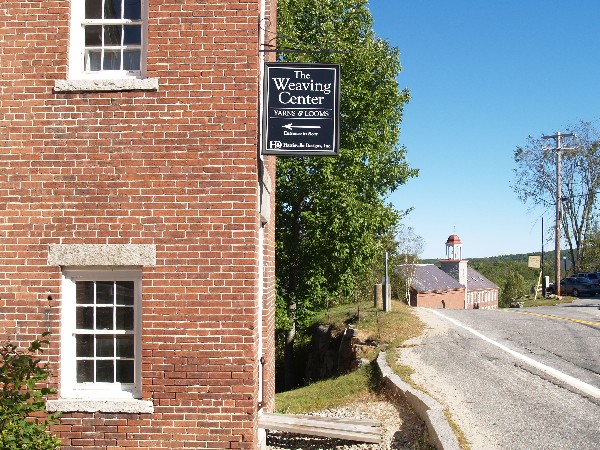
image_
imagesize =
image_caption = The historic mill village of Harrisville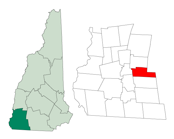
mapsize = 250px
map_caption = Location in Cheshire County,New Hampshire
settlement_type = Town
mapsize1 =
map_caption1 =
subdivision_type = Country
subdivision_name =United States
subdivision_type1 = State
subdivision_name1 =New Hampshire
subdivision_type2 = County
subdivision_name2 = Cheshire
government_type =
leader_title =Board of Selectmen
leader_name = Jay Jacobs
Michael Wilder
Robert Meagher
established_title = Incorporated
established_date = 1870
area_magnitude = 1 E8
area_total_km2 = 52.4
area_total_sq_mi = 20.2
area_land_km2 = 48.5
area_land_sq_mi = 18.7
area_water_km2 = 3.9
area_water_sq_mi = 1.5
area_water_percent = 7.46
population_as_of = 2000
population_note =
population_total = 1075
population_density_km2 = 22.1
population_density_sq_mi = 57.4
timezone = Eastern
utc_offset = -5
timezone_DST = Eastern
utc_offset_DST = -4
latd = 42 |latm = 56 |lats = 42 |latNS = N
longd = 72 |longm = 05 |longs = 47 |longEW = W
elevation_m = 407
elevation_ft = 1335
website = [http://www.keenenh.com/harrisville/ www.keenenh.com/harrisville/]
postal_code_type =ZIP code
postal_code = 03450
area_code = 603
blank_name = FIPS code
blank_info = 33-34420
blank1_name = GNIS feature ID
blank1_info = 0873620
footnotes =Harrisville is a town in Cheshire County,
New Hampshire ,United States . Besides the town center, it also includes the village of Chesham. The population of the town was 1,075 at the 2000 census.Harrisville, a unique, preserved nineteenth-century mill town, is located in the
Monadnock Region of southern New Hampshire. The mill buildings in Harrisville look virtually the same as they did nearly 150 years ago, and theHarrisville Historic District that includes the center of town is aNational Historic Landmark . With the red brick buildings and mills reflected in Harrisville Pond and Canal, the village is a frequently photographed example of old New England.There are nine bodies of water in the town, many back roads and trails to explore, and two original train depots at Harrisville and Chesham.
The elementary school is Wells Memorial School in Chesham. It has about 55 pupils up to grade 6.
History
Settled in 1760, Harrisville township was formed in 1870 from lands ceded by Dublin, Hancock, Marlborough, Nelson, and Roxbury.
Geography
According to the
United States Census Bureau , the town has a total area of convert|20.2|sqmi|km2, of which convert|18.7|sqmi|km2|abbr=on is land and convert|1.5|sqmi|km2|abbr=on is water, comprising 7.46% of the town. The highest point in Harrisville is the summit of Cobb Hill, at convert|1909|ft|m abovesea level . Roughly the western half of Harrisville lies within theAshuelot River watershed, while the eastern half is in theMerrimack River watershed.cite book |title=Water Use in New Hampshire: An Activities Guide for Teachers |url=http://nh.water.usgs.gov/Publications/nh.intro.html |last=Foster |first=Debra H. |coauthors=Batorfalvy, Tatianna N.; and Medalie, Laura |publisher=U.S. Department of the Interior and U.S. Geological Survey |year=1995]Churches
The Community Church of Harrisville and Chesham was formed from Chesham Baptist Church and Harrisville Congregational Church. Chesham Baptist Church dates back to 1785. The church building was originally built in 1797, re-modeled in 1830, and again re-modeled in 1844. The Evangelical Congregational church of Harrisville dates back to 1840, and the church building was erected in 1840-43.
The Community Church is a member of the
United Church of Christ (UCC) and theAmerican Baptist Association , and it retains a united congregation using both buildings. There is also a Roman Catholic Church in Harrisville.Demographics
As of the
census GR|2 of 2000, there were 1,075 people, 449 households, and 306 families residing in the town. Thepopulation density was 57.4 people per square mile (22.1/km²). There were 698 housing units at an average density of 37.2/sq mi (14.4/km²). The racial makeup of the town was 97.77% White, 0.09% African American, 0.56% Native American, 0.28% Asian, and 1.30% from two or more races. Hispanic or Latino of any race were 0.56% of the population.There were 449 households out of which 31.2% had children under the age of 18 living with them, 55.2% were married couples living together, 8.9% had a female householder with no husband present, and 31.8% were non-families. 26.5% of all households were made up of individuals and 7.8% had someone living alone who was 65 years of age or older. The average household size was 2.39 and the average family size was 2.87.
In the town the population was spread out with 24.8% under the age of 18, 4.6% from 18 to 24, 25.7% from 25 to 44, 30.0% from 45 to 64, and 15.0% who were 65 years of age or older. The median age was 43 years. For every 100 females there were 92.3 males. For every 100 females age 18 and over, there were 87.0 males.
The median income for a household in the town was $48,625, and the median income for a family was $55,083. Males had a median income of $34,625 versus $27,171 for females. The
per capita income for the town was $25,397. About 4.3% of families and 5.7% of the population were below thepoverty line , including 8.0% of those under age 18 and 3.8% of those age 65 or over.References
External links
* [http://www.keenenh.com/harrisville Town website]
* [http://www.nh.gov/nhes/elmi/htmlprofiles/harrisville.html New Hampshire Economic and Labor Market Information Bureau Profile]
* [http://www.accessgenealogy.com/newhampshire/ch/harrisville.htm Historical Information from Access Genealogy]
Wikimedia Foundation. 2010.