- North Stoke, West Sussex
-
For other uses, see North Stoke (disambiguation).
Coordinates: 50°53′13″N 0°35′02″W / 50.887°N 0.584°W
North Stoke 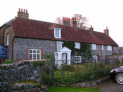
North Stoke Farmhouse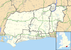
 North Stoke
North Stoke shown within West SussexOS grid reference TQ022107 Parish Amberley District Horsham Shire county West Sussex Region South East Country England Sovereign state United Kingdom Post town Arundel Postcode district BN18 Dialling code 01798 Police Sussex Fire West Sussex Ambulance South East Coast EU Parliament South East England UK Parliament Arundel and South Downs List of places: UK • England • West Sussex North Stoke is a village in the Horsham District of West Sussex, England. It is just over 2 miles (3 km) north of Arundel and 0.7 miles (1 km) south of Amberley railway station, and is at the end of a no through road from the station.
 St. Mary the Virgin parish church, whose dedication was rediscovered in 2007
The village is on a spur of slightly higher ground on the east bank of a loop of the River Arun, surrounded by water meadows. It is in the middle of the gap eroded through the South Downs by the River Arun. Another small settlement on the west bank, South Stoke is about 0.5 miles (1 km) to the south east and can be reached by a footpath and a footbridge over the river. A suspension bridge on the path was rebuilt by British Army Gurkhas in 2009 after being damaged by a falling tree.[1]
Contents
Manor
North Stoke is a medieval village, recorded in the Domesday Book of 1086. It has lost most of its population, possibly due to Black Death in the Middle Ages or because the landowner preferred to enclose the land for sheep pasture. This has left a notable example of an Norman and Early English Gothic church, which is Listed Grade I.[2]
Parish church
Main article: St Mary the Virgin's Church, North StokeThe Church of England parish church of the Virgin Mary is now redundant and maintained by the Churches Conservation Trust.[3] The church's dedication had been long forgotten but in 2007 it was rediscovered from a scrap of a vellum letter dated 1275 from Stephen Bersted, Bishop of Chichester to Edward I. The church was accordingly rededicated to the Virgin Mary in December 2007.[4].
References
- ^ "Historic suspension footbridge to be restored by Gurkhas". West Sussex County Council. 23 April 2009. http://www.westsussex.gov.uk/your_council/news/press_office/press_releases/2009/april_2009/historic_suspension_footbridge.aspx. Retrieved 29 December 2010.
- ^ "Heritage Gateway Listed Buildings Online — North Stoke Church, North Stoke, Amberley, Horsham, West Sussex". Heritage Gateway website. Heritage Gateway (English Heritage, Institute of Historic Building Conservation and ALGAO:England). 2006. http://www.heritagegateway.org.uk/Gateway/Results_Single.aspx?uid=298275&resourceID=5. Retrieved 30 December 2010.
- ^ Watney, Simon (2007). 20 Sussex Churches. Alfriston: Snake River Press. p. 62. ISBN 978-1-906022-00-6.
- ^ Caroline Lewis (11 December 2007). "Mystery of Sussex church solved by archaeology students". Culture24. http://www.culture24.org.uk/history+%2526+heritage/archaeology/art52481. Retrieved 27 November 2009.
Further reading
- Nairn, Ian; Pevsner, Nikolaus (1965). Sussex. The Buildings of England. Harmondsworth: Penguin Books. pp. 283–284. ISBN 0 14 071028 0.
Categories:- Horsham
- Villages in West Sussex
- West Sussex geography stubs


Wikimedia Foundation. 2010.