- Dumka
-
This article is about the municipality in India. For its namesake district, see Dumka district. For the Slavic musical form, see Dumka (musical form).
Dumka — city — Coordinates 24°16′N 87°15′E / 24.27°N 87.25°ECoordinates: 24°16′N 87°15′E / 24.27°N 87.25°E Country India State Jharkhand District(s) Dumka Population
• Density
1,321,096 (2011[update])
• 300 /km2 (777 /sq mi)
Sex ratio 974 ♂/♀ Time zone IST (UTC+05:30) Area
4,404.02 square kilometres (1,700.40 sq mi)
• 137 metres (449 ft)
Website dumka.nic.in Dumka, headquarters of Dumka district, is a city and municipality in the state of Jharkhand, India. It was made the headquarters of the Santhal Pargana region which was carved out of Bhagalpur and Suri districts after The Great Santal Hul 1855. Presently, it is the commissionary headquarter of Santal Pargana division which has 6 districts. It was bestowed the status of sub-capital of Jharkhand state.
Contents
Origin of name
There are two theories as to how Dumka got its present name. The first one being that Dumka got its name from the santali word Dumk which mean "shunted" or "small". Back during the British Raj it was a small town compared to suri and bhagalpur and hencce the name.
The other theory is that Dumka derives its name from a Persian word damin-i-koh, which means 'skirts (an edge, border or extreme part) of the hills'. The Mughals assigned this name to this and nearby areas on account of presence of hillocks and undulating terrain.
List Of NGOs
- Northern Evangelical Lutheran Church
(N.E.L.C.)
- New Human Welfare
www.newhumanwelfare.org, A very fast growing NGO works to make the district developed and for the welfare of Poor peoples.
- Tapasthali Trust
www.tapasthali.in,An NGO working in various fields including Education and Sanitation.
- Ananda Marga
Ananda Marga is a religious Sociey founded by P.R Sharkar in 1955 at Jamalpur and ashram in Dumka. For more details, kindly follow : http://www.anandamarga.org
- Evangelical Social Action Forum (ESAF)
website of esaf, Evangelical Social Action Forum (ESAF) a Kerala based NGO working among the poor and undeveloped people of Jharkhand especially among children in Dumka.
Geography
Dumka is located at 24°16′N 87°15′E / 24.27°N 87.25°E.[1] It has an average elevation of 137 metres (449 feet).
The Dumka district has an area of 3716.02 km2 and consists of only one sub division namely Dumka. Under the Dumka sub division, there are 10 blocks namely Dumka, Gopikander, Jama, Jarmundi, Kathikund, Maslia, Ramgarh, Raneshwar, Shikaripara and Saraiyahat.
Dumka District have many popular temples like Basukinath, Sirshanath, Maluti Mandir, Shiv Pahar, Dharamsthana. A lots of crowd visit these place during the month of Sawan. Babadham is also the most popular temple but it is situated in Deoghar District near the Dumka District.

Deoghar, Allahabad, Kanpur, New Delhi Bhagalpur, Purnia, Godda, Hashdia Siliguri, Guwahati, Shillong Giridih, Hazaribagh 
Rampurhat, Dhaka, Aizawl  Dumka
Dumka 

Dhanbad, Chittranjan Rourkela, Asansol, Durgapur Suri, Kolkata, Bay of Bengal Physiography
Dumka has predominantly undulating terrain with hard rocks in the underground. The entire district has a topography with high ridges and valleys bounded by mountains and rivers. The fertility of soil is poor due to extensive erosion, acidic character and low retaining capacity.
Climate
Dumka has a warm-temperate climate, with warm, humid summers and mild, damp winters.
Climate data for Dumka Month Jan Feb Mar Apr May Jun Jul Aug Sep Oct Nov Dec Year Average high °C (°F) 18.1
(64.6)21.0
(69.8)25.9
(78.6)30.3
(86.5)30.7
(87.3)30.1
(86.2)28.4
(83.1)28.1
(82.6)28.2
(82.8)27.0
(80.6)23.3
(73.9)19.0
(66.2)25.8 Average low °C (°F) 10.2
(50.4)13.2
(55.8)17.4
(63.3)22.3
(72.1)23.9
(75.0)24.7
(76.5)24.1
(75.4)23.7
(74.7)23.6
(74.5)21.0
(69.8)16.0
(60.8)11.1
(52.0)19.3 Precipitation mm (inches) 9.0
(0.354)15.0
(0.591)21.0
(0.827)35.0
(1.378)72.0
(2.835)198.0
(7.795)343.0
(13.504)293.0
(11.535)273.0
(10.748)116.0
(4.567)9.0
(0.354)7.0
(0.276)116.0
(4.567)Source: Weatherbase [2] History
- Stone-age: On the basis of tools unearthed the original inhabitants appear to be the Mon-khmers and the Mundas.
- Early History: The earlier inhabitants of the present-day district of whom there is same record, it appears, were the Paharias (for example, the Maler and Sauria Paharias). The Greek traveler Megasthenes identified these people as Mallis. He referred to the Sauria Paharias as savars of Orisa.
- Medieval History: Due to inaccessibility of the area caused by the cliffs of the Rajmahal Hills, it was a place of strategic economic importance, with a fort at Teliagarhi.
- After the 1539 victory of Sher Shah Suri at Chousa, the area fell into the hands of the Afghans, but it was soon lost to the Mughals under Akbar when Hussain Quli Khan was made viceroy of Bengal.
- British Period: The English representative, Dr. Gabriel Bokgliton, procured a farman from Shah Jahan.
- 1742-1751: The area of Dumka close to Rajmahal witnessed frequent inroads by the Marathas under Raghoji Bhosle and Peshwa Balaji Rao.
- 1745: Raghoji Bhosle entered Rajmahal via the hills and jungles of Santal Pargana. The early stay of the English was spent in subduing the Paharias.
- 1769: Dumka remained a Ghatwali police post under Birbhum District of Bengal.
- 1775: Dumka was transferred to Bhagalpur Division.
- 1865: Dumka was made an independent district after being carved out of Bhagalpur.
- 1872: Dumka was made headquarters of the whole district of Santal Pargana.
- 1889: Paul Olaf Bodding started his service in India (Dumka/Benagaria) after Lars Olsen Skrefsrud, and Bodding created the first alphabet for the Santhals. The NELC-church was created as a Lutheran Church in this area - before the Catholics had established a mission in this area at all.
- 1902: The first municipality was established.
- 1920: Motor cars and buses were introduced.
- 1952: The Apostolic Prefecture of Malda was erected. In 1962, it was promoted to the Roman Catholic Diocese of Dumka
- 1983: Dumka made divisional headquarters of Santal Pargana.
- 2000: Dumka became the sub-capital of Jharkhand.
- 2011: Dumka is connected with newly built Jasidih - Dumka railway line.
Demographics
As of 2011[update] India census,[3] Dumka had a population of 13,21,096. Males constitute 52% of the population and females 48%. Dumka has an average literacy rate of 62.54%, lower than the national average of 74.4%: male literacy is 75.17% and, female literacy is 49.60%. In Dumka, 12% of the population is under 6 years of age.but after 5 years its literacy rate is increase and now it became 82%,also literacy rate of female is grown and reached up to 79%.
Transport
Dumka is a small town,It is connected with road to the neighboring city.However in july 2011 Dumka is connected with newly built Jasidih - Dumka railway line.Since than city has seen a goring number of three Wheeler on road. Although there is an ongoing work on new railway line,which is connect Dumka to Bhagalpur (Bihar) and Rampurhat (west Bangal) in coming years.
Tourist places
Baba Basukinath Dham
Basukinath is located in Dumka District of Jharkhand. It lies on the Deoghar – Dumka state highway and is around 25 km northwest of Dumka. It is a place of pilgrimage for Hindus. Basukinath Temple is the main attraction here.It is situated on Jasidih Dumka New Railway line and Basukinath Railway Station is the nearest railheads. Ranchi Airport is the nearest airport. It is situated at Jarmundi Block on Dumka Deoghar State Highway at a distance of 24 km from the Distrcit Headquarters Dumka. In a year lacs and lacs people from different parts of country come here to worship Lord Shiva. In the month of Shravan people of several country also come here to worship Lord Shiva. For more details, kindly follow : http://www.bababasukinath.in
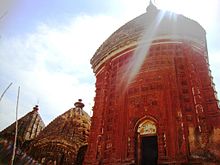
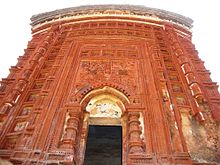
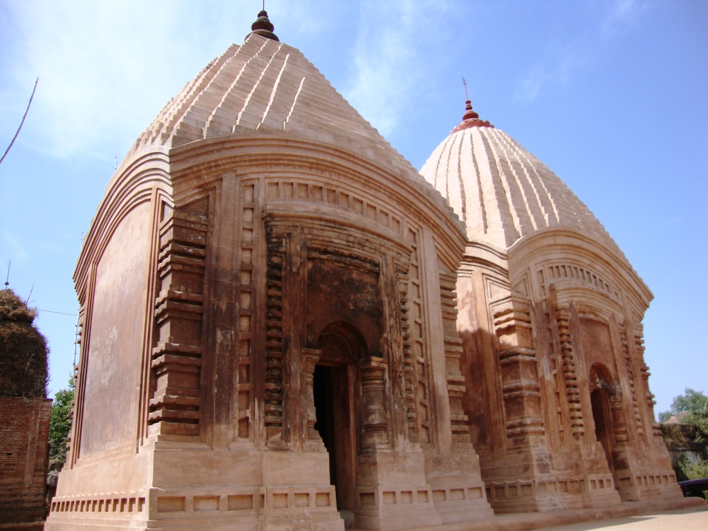
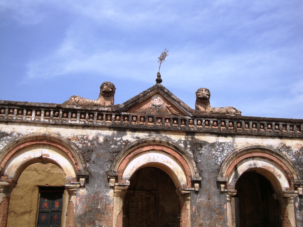
Malooti
Mallooti is a historical and religious place which is situated in Shikaripara Block on Dumka Rampurhat interstate highway at a distance of 55 km from Dumka District Headquarters. In 1860 Mallooti was made taxfree capital by the then King Basant Rai alias Basant. This Mallooti is associated with the archaeological and religious importal place for natural beauty.
 Malooti mandir
 Malooti mandir
 Malooti mandir
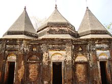 Malooti mandir
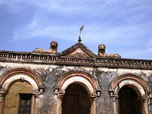 Malooti mandir
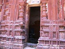 Malooti mandir
Baba Sumeshwar Nath
It is a religious place which is situated in Saraiyahat Block at the distance of 60 km from district headquarters Dumka. There is a big temple of the Lord Shiva. On the eve of Mahashivaratri the people of different parts of the district come here to worship Lord Shiva in addition to daily worshiping.
Masanjore Dam
Masanjore is a famous picnic spot situated in Dumka District of Jharkhand. This small village is about 31 km south of Dumka. The picturesque Masanjore dam on the Mayurakshi River is a major draw. From the counterpart rupee fund created through supplies of wheat and other materials from Canada for use in India, Canada Govt. devoted those funds to further development of the Mayurakshi project And Masanjore dam was commissioned in 1955. That's why the Dam still mentioned as Canada Dam. The dam is bounded by hills and forests, a perfect place for outing. Mayurakshi Bhawan Bungalow and Inspection Bungalow offer excellent and comfortable accommodation in the village. By road, Masanjore is connected with Vakreshwara (59 km), Sainthia (50 km), Tarapith (70 km), Rampurhat (62 km) and Deoghar (98 km). Masanjor dam or the Pearson dam on river Mayurakshi is a picturesque place on foot hills of long range of forest clad parallel hill ranges. This place is basically a hydro electric power generating center but in the process of time it has become popular center for the tourist. With the beautiful garden on the down hill and two beautiful Dak-bunglows on the bank of the river at charm to its beauty.
Tatloi
It is a hot water Spring, situated at a distance of 15 km from the district headquarters of Dumka. It is rounded by small mounts, beautiful, attractive and greenish natural atmosphere. The water of spring is very clear and healthy.
Kumrabad
This is a very beautiful picnic spot. Just 13 km from the Dumka town, you find a rare view of natural beauty with small hills,beside that smooth flowing Mayurakshi River.
Hill Range
Running south from pakur to godda. The hill range of Dumka seen parallel and terminate in th Mangalbhanga hill. To the south east of Dumka is Ramgarh hills further west two parallel renges of hills also stretch in an easterly direction from Masanjor to Ranibhal. Beside hill ranges some hillocks are also in like (i) Lagwa hil at Nonihat under which lies the Tatloi hot water stream (ii) Hijla hill top. (iii) Sapchala hill top. (iv) Chuto pahadi. Maluti (Temple village on way to Rampurhat).
Kurwa (Shrishti)
It is a small picnic spot about 5 km to the south of Dumka. It has a beautiful park, facilities for boating and a small hill.
Politics
The first Chief Minister of Jharkhand, Babulal Marandi, hailed from Dumka constituency. In the year 2000, when Jharkhand was carved out of Bihar, NDA came to power in Jharkhand with Marandi as the Chief Minister. However, he had to resign and make way for Arjun Munda (BJP) for the post in 2002 following pressure exerted by coalition allies primarily JD(U). Recently, he formed his own party with Stephan Marandi, another political leader of the state.
Shibu Soren is another familiar and famous politician associated with Dumka. His political career has been mired in controversies, starting since Indira Gandhi's prime ministership. Recently, he has been sent to Dumka jail after being convicted of murdering his private secretary Shashinath Jha. But, the Delhi High Court acquitted him of the murder charge of his private secretary because of the lack of the evidences. A number of cases is still pending before the Jamtara Session Court and some of the other courts of the Jharkhand.
Schools and colleges
The district has some good schools and colleges which have been imparting the value of education. Zila School, National School, Govt. Girls School, Dumka Central School, +2 Jharkhand Public School are the Schools which provide education till +2 level. Other schools of repute which provide education till secondary level are Sido Kanhu High School, St. Teresa High school (for girls) and Holy Child, N.E.L.C. Don Bosco School, St. Joseph's High School. other schools of same repute are Ananda Marga School(kurwa),Modern Sainik School, Green Mount Academy, Jharkhand Public School etc. They are known for good standard of education. The town also boasts of having S. P. College and A. N. College which run under the S.K.M. University. S. P. College offers undergraduate, graduate as well as Post graduate courses in various disciplines of science, Arts and commerce. Recently B.Ed. course has also been introduced. It has IGNOU study Centre as well which provides for teaching of IGNOU courses.Another well known University is Birsa Agricultural University which provides technical Education related to Agriculture.
Education
The town has very good colleges and schools. S.P. College leads the pack and offers graduation and Post graduation in social science, pure science, economics, mathematics and other subjects. Dumka also has a polytechnic and an ITI but unfortunately no engineering, medical or dental college, so those who wish to pursue a career in these subjects have to move out of the city. A good number of schools are also there to provide the educational needs of the students of this locality.
S.P. College in Dumka provides vocational courses in education (B. Ed, BCA & BBA). IT also runs an IGNOU centre to provide distance learning education in various certificate, diploma, graduation and post graduation courses.
Banks in Dumka
- Allahabad Bank(Neach Bazar Road)
- Axis Bank(Baghalpur Road)
- Bank of Baroda(Tin Bazar Chock)
- Bank of India(Thana Road)
- Canara Bank(Thana Road)
- Central Bank of India(Tata Showroom)
- HDFC Bank(Thana Road)
- Indian Bank
- ICICI Bank(Chuha Bagan)
- Oriental Bank of Commerce(Neach Bazar)
- Panjab National Bank(Bagalpur Road)
- SBI Main Branch(Court Road)
- SBI Bazar Branch(Near Yag Maidan)
- SBI AMY Branch(Dudhani)
- Union Bank of India
- United Bank of India
- UCO Bank(kuldeep singh Road)
- Vananchal Gramin Bank
ATMs in Dumka
- Axis Bank
- Bagalpur Road
- Near Dharmastan(Beside Mani Dress)
- Shiv Pahar Chock
- HDFC Bank
- Thana Road
- ICICI Bank
- Chuha Bagan
- PNB
- Bagalpur Road
- SBI
- Dudhani
- Tin Bazar Chock 3-Beside Raymond Showroom
- Court Road
- LIC
- Union Bank of India
- Niche Bazar
References
- ^ Falling Rain Genomics, Inc - Dumka
- ^ "Weatherbase: Weather for Dumka, India". Weatherbase. 2011. http://www.weatherbase.com/weather/weather.php3?s=425991&refer=&units=us. Retrieved on November 22, 2011.
- ^ "Census of India 2001: Data from the 2001 Census, including cities, villages and towns (Provisional)". Census Commission of India. Archived from the original on 2004-06-16. http://web.archive.org/web/20040616075334/http://www.censusindia.net/results/town.php?stad=A&state5=999. Retrieved 2008-11-01.
External links
Cities and towns in Santhal Parganas Deoghar district Dumka district Basukinath • DumkaGodda district Godda • Lalmatia CollieryJamtara district Pakur district Sahebganj district Related topics Santhal Pargana Division topicsCities and towns
in other DivisionsCategories:- Places of Anga Pradesh
- Cities and towns in Dumka district


Wikimedia Foundation. 2010.