- Old Harford Road
-
Old Harford Road, one of the oldest continuously-used rights-of-way in central Maryland, United States, is a southwest-northeast thoroughfare in northeast Baltimore and eastern Baltimore County.
Present-day Old Harford Road begins in the 6000 block of Harford Road in the Hamilton section of Baltimore City and continues 5½ miles northeast through the Parkville and Carney areas of Baltimore County to near the Big Gunpowder Falls north of Cub Hill. Old Harford Road serves as an alternate route to both Harford Road (Maryland Route 147) and Perring Parkway (Maryland Route 41), and carries between 10,000 and 16,500 vehicles per day. Old Harford Road, like Harford County, was named for Henry Harford (1758–1834), the son of Frederick Calvert, 6th Lord Baltimore, and the last Proprietary of Maryland prior to the American Revolutionary War.
Contents
History
Old Harford Road follows a curving path along relatively high land bordering streams that feed the upper Chesapeake Bay, including Chinquapin Run. This suggests its likely origin as an Indian trail that later was adopted by settlers to convey farm products from northeastern Baltimore County and Harford County to the port of Baltimore in the late 18th century. The name "Old Harford Road" appears on area maps dating back to at least the 1850s (see, for example, map display in the Meeting Room of the Baltimore County Public Library in Towson). The 1850 J. C. Sidney map[1], for example, indicates that all or parts of today's Satyr Hill, Cromwell Bridge and Glenarm Roads collectively were known as Old Harford Road. This naming most likely dates to the period shortly after private interests constructed the more direct "Harford Turnpike" (now known as Harford Road) between present-day Mt. Vista Road and what later became the Hamilton section of Baltimore in 1816.
While Old Harford Road has never been part of the Maryland State Highway system, rapid urban development throughout the Parkville-Carney area following World War II brought substantial traffic increases to the city- and county-maintained road. In particular, completion of the nearby Parkville High School and Perring Plaza Shopping Center spurred increases in the late 1950s and early 1960s, respectively. Major improvements (including widening, resurfacing and construction of curbs/sewers) occurred over various segments in the following years: 1971, 1972, 1975, 1979, 1984, 1990, 2000, and 2001. Construction of an overpass at the Baltimore Beltway (Interstate 695) in 1961 resulted in relocation of the roadway about 300 feet (91 m) west of the original right-of-way. This reconstruction also eliminated an existing "y" intersection with Satyr Hill Road.
The Maryland State Highway Administration currently (August 2009) is in the final engineering phase of a proposed project to widen the Baltimore Beltway between Perring Parkway and Harford Road (see http://www.marylandroads.com/WebProjectLifeCycle/ProjectInformation.asp?projectno=BA458213).[1] This project would include replacement of the Old Harford Road - Interstate 695 overpass. The new bridge will accommodate three lanes of traffic: one through lane in each direction, and a third for left turns from Old Harford onto Satyr Hill Road. The bridge also will provide shoulders for bicycle use and sidewalks.
Points of interest
Several sites of historical interest exist along Old Harford Road. The first four have been placed on the Baltimore County Landmarks List and include:
- The 19th century Krause lime kiln near Summit Avenue (image below). The stone arch kiln burned wood to generate heat for the pulverization of limestone into lime. This process took two to three days, and lime obtained from the kiln was used to reduce soil acidity of area vegetable farms. The kiln was restored by the County in 1979 and is now part of Krause Memorial Park.[1]
- The 1860 Pine Grove School. This one-room school house at the southeast corner of Old Harford and Cub Hill Roads was sold in 1939 and is now a private residence.[1]
- The Federal-style Cub Hill House at 9301 Old Harford Road (just north of Summit Ave; image below). This late 18th century - early 19th century stone structure was once the center of Cub Hill Farm, complete with blacksmith and wheelwright shops, greenhouses and tenant houses. In the mid-19th century a wooden addition (no longer existent) at the west end of the house served as a general store and as the Cub Hill Post Office. The Cub Hill land grant of which Cub Hill Farm was a part dates to the late 17th century. The farm gradually shrank from about 1,000 acres (4.0 km2) to just 50 acres (200,000 m2) when the last owners to farm it (the Macklins) sold it for development in 1952. Cub Hill House and 2 acres (8,100 m2) of the farm have been owned by the Old family since then.[1][2]
- The Shanklin-Carroll-Longbottom homestead just south of Waldor Drive. The land grant of which the home is a part dates to 1695. In 1845, 50 acres (200,000 m2) of the original 500-acre (2.0 km2) tract known as "Bear Neck" was purchased by John Wesley Shanklin. Shanklin enlarged the original home, believed to have been built in the early 19th century, and operated a general store.[1]
- The superstructure of one of the Maryland State Forest Service's former network of fire lookout towers (image below). The tower, at 9405 Old Harford Road, Cub Hill, is located at one of the highest points in eastern Baltimore County (484 feet above sea level). The 125-foot (38 m) tower has not been used for lookout purposes since 1972. It is now used to support communication equipment, while the surrounding grounds serve as an ecological and atmospheric research facility of the Maryland Department of Natural Resources in cooperation with the U.S. Forest Service (See http://www.umbc.edu/ges/student_projects/Cubhill/Cub%20Hill%20Web%20Page/cubhill_homepage.html).[1]
- The Maryland State Training School For Boys. This facility, now known as The Charles H. Hickey School after a former Baltimore County sheriff, originated as a house of refuge in southwest Baltimore. It moved to its present location at the north end of Old Harford Road in 1910, and contains several buildings displaying what might be termed "early 20th century institutional" architecture. In recent years the facility has been the subject of various proposals for conversion to other uses. (See http://www.djs.state.md.us/hickey.html and http://www.explorebaltimorecounty.com/news/2861/rezoning-sets-limits-hickey-propertys-future/)
- The Parkville Precinct (#8) of the Baltimore County Police Department, 8532 Old Harford Road (at southwest corner with Putty Hill Avenue), since October 1954. In August 2007 a new 17,000-square-foot (1,600 m2) facility was dedicated at the same location (See http://www.baltimorecountymd.gov/Agencies/police/pc08/history.html).
- The Parkville station (#10) of the Baltimore County Fire Department (at southwest corner with Putty Hill Avenue), since October 1954. In September 2005 the station occupied a brand-new facility adjacent to the Parkville police department (See http://www.baltimorecountymd.gov/Agencies/fire/stationinfo/st10parkville.html). Until the late 1950s, Putty Hill Avenue (then known as Putty Hill Road) did not extend west of Old Harford Road; an existing dead-end street known as "Miller Avenue" was consumed by Putty Hill's extension west of Old Harford Road around 1960.
Numerous places of worship, schools, and business areas are located on Old Harford Road. These include (listed from south to north):
- Calvary Tabernacle (north of Harford Road). Until 1983, the Tabernacle was housed in an 1874 structure on the same site that, for many years, served as Saint Andrew's Episcopal Church (image below) [3]
- Christ and Country Church (at Roselawn Avenue)
- Hamilton Elementary School (at Christopher Avenue)
- Hamilton Assembly of God Church (near Pinewood Avenue)
- Calvary Lutheran Church and School (at Northern Parkway)
- Putty Hill Shopping Center (at Putty Hill Avenue)
- Morningside House (nursing facility; at Lakewood Road)
- Harford Hills Elementary School (near Joppa Road)
- Atonement Lutheran Church (south of Proctor Lane)
- Pine Grove Middle School (at Proctor Lane)
- Saint Isaac Jogues Roman Catholic Church (north of Proctor Lane)
- Loch Raven Lutheran Church (south of Summit Avenue)
-

19th Century Lime Kiln, Old Harford Road near Summit Ave, Cub Hill, Baltimore County, MD
-

Cub Hill House, Old Harford Road near Summit Ave, Cub Hill, Baltimore County, MD
-

Fire lookout tower, Old Harford Road, Cub Hill, Baltimore County, MD, Nov. 1982
-
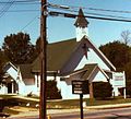
Calvary Tabernacle (formerly Saint Andrew's Episcopal Church), Baltimore, MD, built in 1874
-

Map of northeast Baltimore City (yellow) and County (white), showing location of Old Harford Road (Maryland State Highway Administration)
-

Old Harford Road at Chesley Avenue, Baltimore City, MD, looking north
-

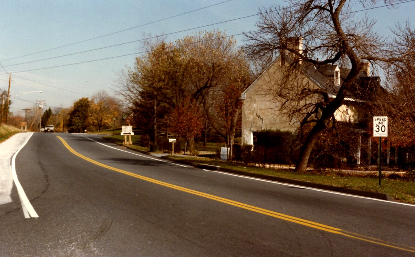
Old Harford Road near Lakewood Road, Carney, Baltimore County, MD, looking north
Major intersections
Major intersections with commercial and/or institutional development along Old Harford Road include (listed south to north):
- Harford Road
- Northern Parkway
- Taylor Avenue
- Putty Hill Avenue
- Satyr Hill Road
- Joppa Road
- Cub Hill Road
See also
- Hamilton, Baltimore
References
- ^ a b c d e f g "The City and County of Baltimore, Maryland." Map from surveys of J. C. Sidney, C.E., and P. J. Browne. James M. Stephen, publisher, Baltimore (1850).
- ^ Northeast Baltimore County Historical Committee, and Rosedale Federal Savings and Loan Assoc. (1989). "A Trip Into The Past", p. 6.
- ^ [7]
5. Adams, S (1982). "Living A Landmark," The (Parkville) Reporter (Patuxent Publishing Company), 3 November 1982, pp. 1, 16-18.
6. Northeast Baltimore County Historical Committee, and Rosedale Federal Savings and Loan Assoc. (1989). "A Trip Into The Past", p. 6.
7. Chamblee, A (1982). "New Life For Old Tower," The (Parkville) Reporter (Patuxent Publishing Company), 15 September 1982.
8. Corso, G (1990). "Calvary Tabernacle Buys Hamilton's Equitable Bank Building," Herald Gazette, May 1990, pp. 1 and 11.- Baltimore County Public Library's Legacy Web Page
- Historical Society of Baltimore County
- Harford Park Community Organization (http://www.harfordpark.org/; numerous references to Old Harford Road in on-line community document archives)
- Parkville-Carney Business Association (see http://www.parkvillecarney.com/history.htm for additional information on the history of Old Harford Road).
Categories:- Roads in Maryland
- Roads in Baltimore County, Maryland
- Roads in Baltimore, Maryland
- Streets in Baltimore, Maryland


Wikimedia Foundation. 2010.