College Avenue (Metra)

College Avenue (Metra)
Metra logo negative.png
College Avenue
CollegeAve UP-W.jpg
Station statistics
Address 303 N. President Street
Wheaton, Illinois
Coordinates 41°52′07″N 88°05′25″W / 41.8685°N 88.0903°W / 41.8685; -88.0903Coordinates: 41°52′07″N 88°05′25″W / 41.8685°N 88.0903°W / 41.8685; -88.0903
Lines
Connections Pace bus
Platforms 2 Side platforms
Tracks 3
Other information
Accessible Handicapped/disabled access
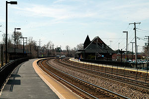
Fare zone E
Services
Preceding station   Metra   Following station
toward Elburn
Union Pacific/West
toward Ogilvie

College Avenue is one of two stations on Metra's Union Pacific/West Line, located in Wheaton, Illinois. The station is located at 303 N. President Street in Wheaton, and lies next to Wheaton College. The station is located 23.8 miles (38.3 km) away from Ogilvie Transportation Center, the eastern terminus of the West Line.[1] In Metra's zone-based fare system, College Avenue is in zone E.

College Avenue station is located at ground level and consists of two side platforms. Three tracks run between the platforms, though one does not access the station. There is a station house next to the inbound (north) track, which is open 24 hours. Tickets are available at the station house on weekdays. The Illinois Prairie Path runs along the south edge of the complex.

Bus connections

Pace

  • #706 SW Glen Ellyn/SE Wheaton Feeder
  • #714 College of DuPage-Naperville-Wheaton Connector
  • #715 Central DuPage

References

External links


Wikimedia Foundation. 2010.

Игры ⚽ Поможем сделать НИР

Look at other dictionaries:

  • Elmhurst (Metra) — Infobox Station name=Elmhurst type=Metra regional rail image size= image caption=A Metra train departing Elmhurst heading for Chicago address=128 W. 1st Street at York Road Elmhurst, IL coordinates= line=Rail color box|system=Metra|line=Union… …   Wikipedia

  • Michigan Avenue (Chicago) — Michigan Avenue 100 East South end: 12628 South North end: 950 North Michigan Avenue is a major north south street in Chicago which runs at 100 east (except for one private block that runs at 125 east) south of the Chicago River and at… …   Wikipedia

  • Chicago Aurora and Elgin Railroad — Map of the Chicago Aurora and Elgin Railroad from a 1936 public timetable folder …   Wikipedia

  • Wheaton, Illinois — Chicagoland municipality muni name = Wheaton muni = City date = 1859 state = Illinois county = DuPage township = Milton gov = Council manager head label = Mayor gov head = Michael J. Gresk pop = 55,416 elevation ft = 758 status = up percent =… …   Wikipedia

  • Union Pacific/West Line — Infobox rail line name = Union Pacific/West Line image width = 250px caption = The River Forest station on the line, located in River Forest, Illinois type = Commuter Rail system = Metra status = locale = start = Ogilvie Transportation Center end …   Wikipedia

  • Blue Line (Chicago Transit Authority) —      Blue Line A Blue Line train in the Damen station Overview Type …   Wikipedia

  • Red Line (Chicago Transit Authority) —      Red Line A Red Line train in the Jackson/State station Overview Type …   Wikipedia

  • Chicago — This article is about the U.S. city. For other uses, see Chicago (disambiguation). Windy City redirects here. For other uses, see Windy City (disambiguation). Chicago   City   City of Chicago …   Wikipedia

  • Naperville, Illinois — Coordinates: 41°44′53″N 88°09′56″W / 41.74806°N 88.16556°W / 41.74806; 88.16556 …   Wikipedia

  • Chicago — Pour les articles homonymes, voir Chicago (homonymie). 41° 52′ 57″ N 87° 37′ 51″ W …   Wikipédia en Français

Share the article and excerpts

Direct link
Do a right-click on the link above
and select “Copy Link”