- Château-d'Œx
-
Château-d'Œx 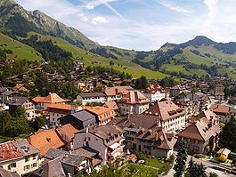
Country Switzerland 
Canton Vaud District Riviera-Pays-d'Enhaut 46°28′N 7°7′E / 46.467°N 7.117°ECoordinates: 46°28′N 7°7′E / 46.467°N 7.117°E Population 3,180 (Dec 2009)[1] - Density 28 /km2 (72 /sq mi) Area 113.76 km2 (43.92 sq mi) Elevation 958 m (3,143 ft) Postal code 1660 SFOS number 5841 Surrounded by Charmey (FR), Grandvillard (FR), Gsteig bei Gstaad (BE), Haut-Intyamon (FR), Ormont-Dessous, Ormont-Dessus, Rossinière, Rougemont, Saanen (BE), Villeneuve Website www.chateau-doex.ch
Profile, SFSO statistics
 Château-d'Œx
View map of Château-d'Œx Château-d'Œx is a municipality in the canton of Vaud in Switzerland. It is in the district of Riviera-Pays-d'Enhaut.
Contents
History
Château-d'Oex is first mentioned in 1115 as Oit, Oyz, Oix and Oyez.[2]
Prehistoric settlements
During the late Paleolithic and Mesolithic (9500 to at least 6000 BC) caves around Château-d'Oex served as a seasonal settlement. Bronze Age knives indicate that there was a settlement during that era as well. Many of the local names (combe = valley, joeur = forest, man= rock)and the local dialect are the only traces of a celtic settlement in the area. The lack of iron ore and the sparseness of the soil probably prevented the romanization of lowland valleys. During the Gallo-Roman era, the region may have been only sparsely populated. By the 10th Century, the Alamannic settlements had only reached Le Vanel but then spread even higher and reached the pastures in L'Etivaz in the southern part of the municipality. The valley was known as the high Gau or Ogo. The name may have come from the word for Ox or be a form of Äesch, (or ash).[2]
Medieval history
In the 10th Century, the Count of Gruyere conquered La Tine and the Creux de l'Enfer. Subsequently it was merged with Rossinière to form a district. The church of St. Donat was consecrated and first mentioned in 1175. The village church was under the authority of the Cluniac Priory of Rougemont, which was founded in 1080.
At the beginning of the 14th Century, the castle at La Motte was rebuilt for the Counts of Gruyere. Another stronghold probably stood on the rocky spur which was known as Château Cottier. After clearing the woods, the region was intensively farmed and produced barley, hay, hemp and cheese. In 1388 the villagers threw off the obligation to serve the nobility. Then, in 1403, against the wishes of the Count of Gruyères, the villagers joined a limited alliance with Bern.[2]
Growth during the Early Modern era
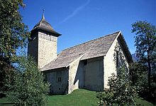 Old church in Château-d'Oex
In 1555 Bern received the upper part of the county of Gruyere including Château-d'Oex. It became part of the German-speaking bailiwick of Saanen. The rights and freedoms of the villagers were now based on Bernese law and not on the Land Law of Moudon. However, the village church was still part of the parish under the collegiate church of Lausanne. Following the Protestant Reformation in 1555, the parish also included Etivaz until 1713.
Under Bernese rule, the economy experienced a strong upswing. The common land was divided and sold before the end of the 16th Century. The alpine pastures were leased to private cheese makers, who there produced Gruyere cheese. In the 18th Century, the inhabitants of the municipality sold the cheese, from the approximately 2,000 cows, at the market in Vevey. From there it went over the Col de Jaman to Marseille where it was exported to Asia and America.[2]
End of the Ancien Regime and Modern Château-d'Oex
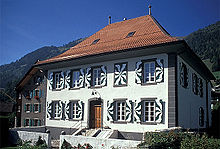 House in the historic center of Château-d'Oex
In 1798, Château-d'Oex came to the newly formed Canton of Léman. In 1800, a fire destroyed the wooden houses on the central hill. The houses had been built in this style and on the hill to avoid property taxes. Thanks to the efforts of the Dean Philippe-Sirice Bridel enough money was raised to rebuild the houses in stone. The municipality hired masons from Savoy, carpenters from Simmental and plasterers from the lower Gruyere lands lower uplands. In 1803, the Canton of Léman was dissolved with the Act of Mediation and the municipality became part of the new canton of Vaud.[2]
In 1849, the Institute Henchoz opened as a preparatory gymnasium, which replaced the older Latin school. The primary school received a new building in 1907. Starting in 1847 a parish of the Free Church of the Canton of Vaud was established with two priests. The Catholic parish was established in 1896 and the Anglican church parish was created in 1899. Other religious communities, such as the Plymouth Brethren, established churches in the valley.[2]
In the 19th Century, the municipality suffered several several outbreaks of livestock diseases. To protect the dairy industry, non-local herds were forbidden from passing through the municipality. Cheese was no longer allowed to be carried across the mountains but was now transported on local draft horses. Due to customs taxes with the neighboring Canton of Fribourg, cheese was carried on a route over the Col de Chaude to Villeneuve (VD) and from there to the shores of Lake Geneva, without crossing the Fribourg border. The abolition of the inter-canton customs and taxes in 1848 led to the demolition of the Fribourg customs station on the main road that had linked Château-d'Oex with the grain and livestock markets. Changes in markets and improvements in animal husbandry led to more Simmental cattle being raised for meat rather than cheese production. The construction of the road over the Col des Mosses (1865–71) and the construction of a new road to Bulle (1895) eased transportation.[2]
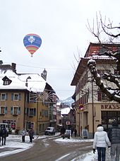 Balloon above the streets of Château-d'Oex
The hospital, which had replaced the old hospital in 1926, was remodeled in 1979 into a nursing home and district hospital. At the same time, solar heating was added to the building. The municipal administration building was built in 1912, and renovated in 1958. The Musée du Vieux Pays-d'Enhaut was built in 1922.
Until 1953 the Liberal party (PLS) and the Parti radical-démocratique suisse {PRD) were separate parties that each published their own newspaper. The PRD paper "Le Progrès", however merged in 1940 into the (PLS), "Journal de Château-d'Œx", which became in 1989 the "Journal du Pays d'Enhaut". The socialist and agrarian parties were not represented in the local parliament until 1957 when proportional representation was introduced.[2]
A power plant operated in La Chaudanne was from 1894 until about 1901. The opening of the Montreux-Oberland Bernois Railway (MOB) in 1904 made Château-d'Oex an attractive summer resort. It was particularly appreciated by English tourists. Between 1916-18 it also housed English internees during the war. Half a dozen grand hotels with tennis courts sprang up in the municipality. A tennis club was founded in 1894. Other infrastructure included the suspension bridge at Turrian (1883), a swimming pool and a campsite (1932), a cable car (1945) and the Pont du Berceau (1945). The agricultural sector has remained important, with the emphasis again shifting to cheese. In the 20th Century, winter tourism became an important additional source of income. Hot air balloons and river rafting became common in the summer, while local crafts, sawmills and gravel mining are the main branches of the industrial sector. Since 1945, the area around Pierreuse has been a protected heritage site.[2]
Geography
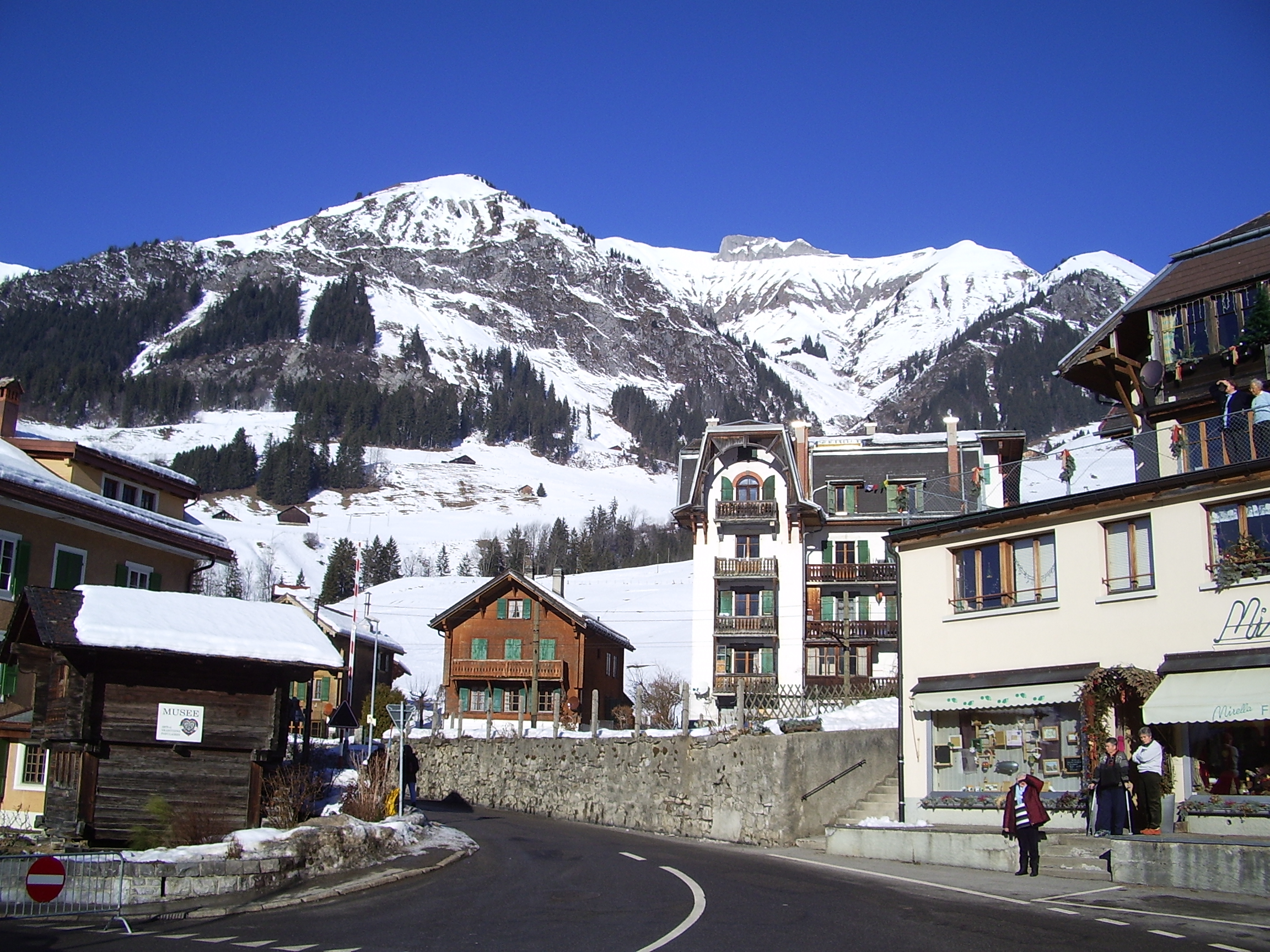
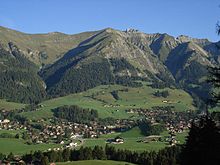 View of Château-d'Oex and the surrounding mountains
Château-d'Oex has an area, as of 2009[update], of 113.7 square kilometers (43.9 sq mi). Of this area, 50.67 km2 (19.56 sq mi) or 44.6% is used for agricultural purposes, while 40.8 km2 (15.8 sq mi) or 35.9% is forested. Of the rest of the land, 3.29 km2 (1.27 sq mi) or 2.9% is settled (buildings or roads), 1.11 km2 (0.43 sq mi) or 1.0% is either rivers or lakes and 17.74 km2 (6.85 sq mi) or 15.6% is unproductive land.[3]
Of the built up area, housing and buildings made up 1.3% and transportation infrastructure made up 1.2%. Out of the forested land, 30.0% of the total land area is heavily forested and 3.8% is covered with orchards or small clusters of trees. Of the agricultural land, 0.1% is used for growing crops and 10.5% is pastures and 34.0% is used for alpine pastures. Of the water in the municipality, 0.4% is in lakes and 0.6% is in rivers and streams. Of the unproductive areas, 9.3% is unproductive vegetation and 6.3% is too rocky for vegetation.[3]
The municipality was part of the Pays-d'Enhaut District until it was dissolved on 31 August 2006, and Château-d'Oex became part of the new district of Riviera-Pays-d'Enhaut.[4]
The municipality is the largest in land area in the canton. It is located in the upper Saane valley. In the 14th to 18th Centuries, the seven établées of Sous le Scex, Mont, Village, Frasse, Entre deux Eaux, Monteiller and L'Etivaz merged into the municipality. It consists of the villages of Château-d'Oex, L' Etivaz, Les Moulins and Les Granges, 35 hamlets and 22 alpine herding camps.
Coat of arms
The blazon of the municipal coat of arms is Gules, a tower embattled Or, a wall embattled of the same in the dexter, surmounted by a crane Argent[5]
Demographics
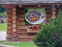 L'Etivaz village
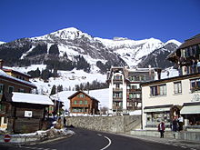 Château-d'Oex
Château-d'Oex has a population (as of December 2009[update]) of 3,180.[1] As of 2008[update], 19.1% of the population are resident foreign nationals.[6] Over the last 10 years (1999–2009 ) the population has changed at a rate of 5%. It has changed at a rate of 8.8% due to migration and at a rate of -3.6% due to births and deaths.[7]
Most of the population (as of 2000[update]) speaks French (2,611 or 88.5%), with German being second most common (105 or 3.6%) and English being third (71 or 2.4%). There are 19 people who speak Italian.[8]
The age distribution of the population (as of 2000[update]) is children and teenagers (0–19 years old) make up 23.9% of the population, while adults (20–64 years old) make up 54.6% and seniors (over 64 years old) make up 21.5%.[7]
As of 2000[update], there were 1,140 people who were single and never married in the municipality. There were 1,422 married individuals, 227 widows or widowers and 160 individuals who are divorced.[8]
As of 2000[update] the average number of residents per living room was 0.53 which is less people per room than the cantonal average of 0.61 per room.[7] In this case, a room is defined as space of a housing unit of at least 4 m² (43 sq ft) as normal bedrooms, dining rooms, living rooms, kitchens and habitable cellars and attics.[9] About 48.5% of the total households were owner occupied, or in other words did not pay rent (though they may have a mortgage or a rent-to-own agreement).[10]
As of 2000[update], there were 1,350 private households in the municipality, and an average of 2.1 persons per household.[7] There were 550 households that consist of only one person and 92 households with five or more people. Out of a total of 1,381 households that answered this question, 39.8% were households made up of just one person and there were 11 adults who lived with their parents. Of the rest of the households, there are 363 married couples without children, 340 married couples with children There were 66 single parents with a child or children. There were 20 households that were made up of unrelated people and 31 households that were made up of some sort of institution or another collective housing.[8]
In 2000[update] there were 608 single family homes (or 47.8% of the total) out of a total of 1,271 inhabited buildings. There were 342 multi-family buildings (26.9%), along with 217 multi-purpose buildings that were mostly used for housing (17.1%) and 104 other use buildings (commercial or industrial) that also had some housing (8.2%).[11] {
In 2000[update], a total of 1,302 apartments (57.5% of the total) were permanently occupied, while 871 apartments (38.5%) were seasonally occupied and 90 apartments (4.0%) were empty.[11] As of 2009[update], the construction rate of new housing units was 6.6 new units per 1000 residents.[7] The vacancy rate for the municipality, in 2010[update], was 1.54%.[7]
The historical population is given in the following chart:[2][12]

Heritage sites of national significance
The Les Ciernes-Picat, a mesolithic shelter, is listed as a Swiss heritage site of national significance. The entire hamlet of l’Etivaz is part of the Inventory of Swiss Heritage Sites.[13]
Sights
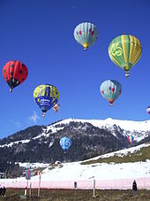 Balloon festival
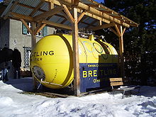 Breitling Orbiter
The world famous "Balloon Week" has been held each year since 1979 in the last week of January. Up to 100 balloonists gather for the festival each year. The Breitling Orbiter 3, the first hot air balloon to circumnavigate the earth, took-off from Château-d'Œx on March 1, 1999. Commemorative insignia (pins) are created for each festival and are sold as pass-tickets to the museum and sportive manifestations for the whole duration of it.
A museum dedicated to Montgolfier type ballons is located in the center of the town.
Politics
In the 2007 federal election the most popular party was the SVP which received 32.23% of the vote. The next three most popular parties were the FDP (18.37%), the SP (16.21%) and the LPS Party (14.68%). In the federal election, a total of 854 votes were cast, and the voter turnout was 41.6%.[14]
Economy
As of 2010[update], Château-d'Oex had an unemployment rate of 2.3%. As of 2008[update], there were 234 people employed in the primary economic sector and about 97 businesses involved in this sector. 252 people were employed in the secondary sector and there were 54 businesses in this sector. 1,012 people were employed in the tertiary sector, with 173 businesses in this sector.[7] There were 1,372 residents of the municipality who were employed in some capacity, of which females made up 43.5% of the workforce.
In 2008[update] the total number of full-time equivalent jobs was 1,196. The number of jobs in the primary sector was 169, all of which were in agriculture. The number of jobs in the secondary sector was 232 of which 60 or (25.9%) were in manufacturing and 156 (67.2%) were in construction. The number of jobs in the tertiary sector was 795. In the tertiary sector; 191 or 24.0% were in the sale or repair of motor vehicles, 50 or 6.3% were in the movement and storage of goods, 116 or 14.6% were in a hotel or restaurant, 15 or 1.9% were the insurance or financial industry, 46 or 5.8% were technical professionals or scientists, 42 or 5.3% were in education and 198 or 24.9% were in health care.[15]
In 2000[update], there were 238 workers who commuted into the municipality and 266 workers who commuted away. The municipality is a net exporter of workers, with about 1.1 workers leaving the municipality for every one entering.[16] Of the working population, 5.5% used public transportation to get to work, and 53.3% used a private car.[7]
Religion
From the 2000 census[update], 527 or 17.9% were Roman Catholic, while 1,746 or 59.2% belonged to the Swiss Reformed Church. Of the rest of the population, there were 12 members of an Orthodox church (or about 0.41% of the population), there was 1 individual who belongs to the Christian Catholic Church, and there were 363 individuals (or about 12.31% of the population) who belonged to another Christian church. There were 9 individuals (or about 0.31% of the population) who were Jewish, and 89 (or about 3.02% of the population) who were Islamic. There were 2 individuals who were Buddhist and 9 individuals who were Hindu. 258 (or about 8.75% of the population) belonged to no church, are agnostic or atheist, and 110 individuals (or about 3.73% of the population) did not answer the question.[8]
Education
In Château-d'Oex about 986 or (33.4%) of the population have completed non-mandatory upper secondary education, and 299 or (10.1%) have completed additional higher education (either University or a Fachhochschule). Of the 299 who completed tertiary schooling, 45.5% were Swiss men, 30.4% were Swiss women, 13.0% were non-Swiss men and 11.0% were non-Swiss women.[8]
As of 2000[update], there were 92 students in Château-d'Oex who came from another municipality, while 95 residents attended schools outside the municipality.[16]
Sport
Skiing is a key activity in the area with the ski station of La Braye accessible via cable car (also open in Summer) from the heart of Château-d'Œx village. The International Hot-Air Balloon Festival in Château-d'Oex is held every year in January, since 1979.
Notable residents
The Dutch graphic artist M. C. Escher and his wife, Jetta Umiker, spent several years in the town.
David Niven, the British actor who played Phileas Fogg in Around the World in 80 Days (1956 film), lived much of his life in Château-d'Œx. He died at his chalet on July 29, 1983 of amyotrophic lateral sclerosis (ALS), at age 73.
Billy Kearns, the American actor, also lived much of his life in Château-d'Œx. He died on November 28, 1992 of lung cancer at age 69.
Weather
Climate data for Château-d'Oex Month Jan Feb Mar Apr May Jun Jul Aug Sep Oct Nov Dec Year Average high °C (°F) 2.1
(35.8)3.8
(38.8)6.9
(44.4)10.8
(51.4)15.5
(59.9)18.7
(65.7)21.5
(70.7)20.7
(69.3)18
(64)13.4
(56.1)6.8
(44.2)2.6
(36.7)11.7 Daily mean °C (°F) −2.7
(27.1)−1.4
(29.5)1.5
(34.7)5.1
(41.2)9.5
(49.1)12.8
(55.0)15.1
(59.2)14.4
(57.9)11.6
(52.9)7.2
(45.0)1.7
(35.1)−2
(28)6.1 Average low °C (°F) −6.3
(20.7)−5.3
(22.5)−2.7
(27.1)0.6
(33.1)4.7
(40.5)7.9
(46.2)9.9
(49.8)9.4
(48.9)7
(45)3.2
(37.8)−1.8
(28.8)−5.3
(22.5)1.8 Precipitation mm (inches) 101
(3.98)100
(3.94)101
(3.98)102
(4.02)113
(4.45)147
(5.79)128
(5.04)142
(5.59)99
(3.9)101
(3.98)115
(4.53)117
(4.61)1,366
(53.78)Avg. precipitation days 11.6 10.7 12.3 12.1 14.4 13.8 11.8 12.6 9.1 8.5 10.6 11.6 139.1 Source: MeteoSchweiz [17] References
- ^ a b Swiss Federal Statistical Office, MS Excel document – Bilanz der ständigen Wohnbevölkerung nach Kantonen, Bezirken und Gemeinden (German) accessed 25 August 2010
- ^ a b c d e f g h i j Château-d'Oex in German, French and Italian in the online Historical Dictionary of Switzerland.
- ^ a b Swiss Federal Statistical Office-Land Use Statistics 2009 data (German) accessed 25 March 2010
- ^ Nomenklaturen – Amtliches Gemeindeverzeichnis der Schweiz (German) accessed 4 April 2011
- ^ Flags of the World.com accessed 09-August-2011
- ^ Swiss Federal Statistical Office - Superweb database - Gemeinde Statistics 1981-2008 (German) accessed 19 June 2010
- ^ a b c d e f g h Swiss Federal Statistical Office accessed 09-August-2011
- ^ a b c d e STAT-TAB Datenwürfel für Thema 40.3 - 2000 (German) accessed 2 February 2011
- ^ Eurostat. "Housing (SA1)" (pdf). Urban Audit Glossary. 2007. p. 18. http://www.bfs.admin.ch/bfs/portal/en/index/international/22/lexi.Document.116365.pdf. Retrieved 12 February 2010.
- ^ Urban Audit Glossary pg 17
- ^ a b Swiss Federal Statistical Office STAT-TAB - Datenwürfel für Thema 09.2 - Gebäude und Wohnungen (German) accessed 28 January 2011
- ^ Swiss Federal Statistical Office STAT-TAB Bevölkerungsentwicklung nach Region, 1850-2000 (German) accessed 29 January 2011
- ^ "Kantonsliste A-Objekte" (in German). KGS Inventar. Federal Office of Civil Protection. 2009. http://www.bevoelkerungsschutz.admin.ch/internet/bs/de/home/themen/kgs/kgs_inventar/a-objekte.html. Retrieved 25 April 2011.
- ^ Swiss Federal Statistical Office, Nationalratswahlen 2007: Stärke der Parteien und Wahlbeteiligung, nach Gemeinden/Bezirk/Canton (German) accessed 28 May 2010
- ^ Swiss Federal Statistical Office STAT-TAB Betriebszählung: Arbeitsstätten nach Gemeinde und NOGA 2008 (Abschnitte), Sektoren 1-3 (German) accessed 28 January 2011
- ^ a b Swiss Federal Statistical Office - Statweb (German) accessed 24 June 2010
- ^ "Average Values-Table, 1961-1990" (in German, French, Italian). Federal Office of Meteorology and Climatology MeteoSwiss. http://www.meteoswiss.admin.ch/web/de/klima/klima_schweiz/tabellen.html. Retrieved 8 May 2009.
External links
- Château-d'Œx in German, French and Italian in the online Historical Dictionary of Switzerland.
- L' Etivaz in German, French and Italian in the online Historical Dictionary of Switzerland.
- Château-d'Œx & Pays-d'Enhaut Tourist Office.
- WikidOex ~ News and views from Château-d'Œx
Blonay | Chardonne | Château-d’Œx | Corseaux | Corsier-sur-Vevey | Jongny | Montreux | Rossinière | Rougemont | Saint-Légier-La Chiésaz | La Tour-de-Peilz | Vevey | Veytaux
Canton of Vaud | Districts of the canton of Vaud | Municipalities of the canton of Vaud
 Categories:
- Municipalities of the canton of Vaud
- Municipalities of Switzerland
- Ski areas and resorts in Switzerland
- Cultural property of national significance in the canton of Vaud


Wikimedia Foundation. 2010.