- U.S. Route 220 in Maryland
-
This article is about the section of U.S. Route 220 in Maryland. For the entire length of the highway, see U.S. Route 220.
U.S. Route 220
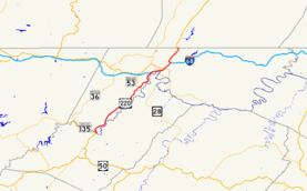
U.S. Route 220 highlighted in redRoute information Maintained by MDSHA Length: 27.35 mi[2] (44.02 km) Existed: 1926[1] – present Major junctions South end:  US 220 in McCoole
 MD 135 in McCoole
 MD 956 in Pinto
 MD 53 in Cresaptown

 I-68 / US 40 in Cumberland
 MD 51 in Cumberland

US 40 Alt. in Cumberland I-68 / US 40 / MD 144 in Cumberland
North end: US 220 in DickensLocation Counties: Allegany Highway system United States Numbered Highways
List • Bannered • Divided • ReplacedMaryland highway system
Interstate • US • State • Minor • Former • Turnpikes←  US 219
MD 221  →
→U.S. Route 220 (US 220) is a part in the U.S. Highway System that runs from Rockingham, North Carolina to Waverly, New York. In Maryland, the federal highway runs 27.35 miles (44.02 km) from the West Virginia state line at the Potomac River in McCoole north to the Pennsylvania state line in Dickens. Known as McMullen Highway for much of its length in Maryland, US 220 is the primary north–south route in central Allegany County, connecting Cumberland with its southern suburbs and Keyser, West Virginia to the south and Bedford, Pennsylvania to the north. The federal highway is part of the National Highway System between the West Virginia state line and Maryland Route 53 (MD 53) in Cresaptown and between Interstate 68 (I-68), with which it is concurrent through Cumberland, and the Pennsylvania state line.[3]
The road to Bedford was paved within the city of Cumberland by 1910 and constructed north to Pennsylvania in the 1910s. This highway comprised the southernmost portion of US 220 when the U.S. Highway System was established in 1927. McMullen Highway was constructed starting from Cumberland and finishing in McCoole in the 1920s. When that highway was completed around 1930, US 220 was extended south into West Virginia. Both the northern and southern portions of the federal highway were reconstructed in the 1940s and 1950s, including a new bridge over the Potomac River. US 220 was rerouted within Cumberland multiple times before being placed on I-68 in the early 1980s to bypass downtown Cumberland. The bypass of Bedford Road between I-68 and the Pennsylvania state line opened in 2000. A new bridge over the Potomac River is currently under construction. In addition, relocation of the highway from I-68 south into West Virginia is under consideration.
Contents
Route description
 US 220 northbound entering Potomac Park
US 220 enters Maryland in southwestern Allegany County, crossing the Potomac River and its own old alignment on a bridge from Keyser to McCoole. The highway meets the eastern terminus of MD 135 (Paxton Street) before gaining a climbing lane and ascending a hill. US 220 crosses over its old alignment again, then meets the old alignment, unsigned MD 135A, at the top of the hill. The federal highway turns northeast as McMullen Highway, a two-lane road paralleling the Potomac River north to Cumberland. The highway passes through the hamlet of Dawson, where it passes a curve of its old alignment designated MD 830A and closely parallels CSX's Mountain Subdivision. US 220 splits away from the railroad tracks to follow the valley of Deep Hollow Creek between Fort Hill immediately to the east and Dans Mountain further to the west. After passing through the hamlet of Danville, the federal highway passes into the valley of Mill Run. After passing another curve of old alignment designated MD 830B, US 220 leaves Fort Hill and Mill Run behind.[2][4]
US 220 passes through the villages of Rawlings and Bier before intersecting the western end of MD 956 (Patriot Parkway) near Pinto. Beyond MD 956, US 220 enters a more densely-populated area, passing through the community of Bel Air. The federal highway enters Cresaptown, where US 220 intersects MD 53 (Winchester Road), which is also the southern terminus of US 220 Truck. Access to northbound MD 53 is provided by unsigned MD 636 (Warrior Drive) shortly after.[2][4]
After crossing Warrior Run, Haystack Mountain flanks US 220 to the west as the federal highway passes through Amcelle, the former site of the Celanese chemical plant that is now the location of the North Branch Correctional Institution. The federal highway curves through Potomac Park, home of the Allegany County Fairgrounds. After passing the Upper Potomac Industrial Park, US 220 parallels CSX's Mountain Subdivision again before entering the city of Cumberland, where the highway is municipally-maintained. Shortly after, US 220 meets I-68 and US 40 (National Freeway) at Exit 42. Trucks and buses are prohibited from using the ramp in the diamond interchange from eastbound I-68 to southbound US 220; those vehicles must follow US 220 Truck instead.[5] Greene Street, the old alignment of US 220, continues north from the interchange as a municipal street toward downtown Cumberland.[2][4]
US 220 becomes concurrent with eastbound I-68 and US 40, passing through downtown Cumberland on a narrow, curvaceous viaduct where the highway meets the northern end of MD 51 and the east end of US 40 ALT. After passing through the eastern part of the city, US 220 exits the freeway at Exit 46 onto MD 144 (Ali Ghan Road), which it follows east a short distance before turning north over I-68 onto a two-lane limited access highway with a speed limit of 55 mph (89 km/h). MD 144, the old alignment of US 40, continues east toward Rocky Gap State Park. The southbound direction of US 220 joins westbound I-68 via a long ramp on a sweeping curve. After crossing Evitts Creek, Mason Road, and Bealls Mill Road, the federal highway reaches the intersection with MD 807 (Bedford Road) and MD 807E (Smouses Mill Road) in Dickens, the former being the old alignment of US 220. US 220 turns northeast, passing MD 807D (Pine Ridge Road) and MD 807C before crossing the Pennsylvania state line, where the route continues north as Bedford Valley Road toward Bedford.[2][4]
History
 US 220 northbound past the split from I-68
Bedford Street was paved in the city of Cumberland from downtown to Naves Cross Road by 1910.[6] Bedford Road was paved between Naves Cross Road and roughly the present intersection of US 220 and Bedford Road by 1915, with the final segment to the Pennsylvania state line completed shortly thereafter.[7][8][9] When the U.S. Highway System was organized in 1926, Bedford Road and Bedford Street were designated the southernmost portion of US 220.[1][10] The first section of McMullen Highway—named for Hugh A. McMullen, an Allegany County miner, merchant, and banker who was Comptroller of Maryland from 1916 to 1920—was completed between Cumberland and Cresaptown in 1920.[8][9][11] The highway was extended to Rawlings by 1927 and to Dawson in 1928.[10][12] McMullen Highway was completed to McCoole by 1930.[13][14][15] The US 220 designation was extended south of Cumberland into West Virginia at the same time.[15] Within Cumberland, US 220 followed Greene Street north and east to Wills Creek. The federal highway crossed Wills Creek via Baltimore Street, which the highway followed east to Henderson Avenue. US 220 was concurrent with US 40 on Henderson Avenue before turning northeast onto Bedford Street.[16] In McCoole, US 220 followed a twisty route down to the Potomac River. The federal highway followed what is today MD 135A to MD 135, then turned east on the present MD 135 and past the present bridge to Parkland Drive, where the highway crossed the river on a bridge in line with Main Street in Keyser.[17]
The first round of improvements to US 220 began around 1936 when the highway was widened from McMullen to Amcelle.[18] The widened highway was extended south through Cresaptown by 1938 and to McCoole by 1942, making all of McMullen Highway at least 20 feet (6.1 m) wide.[19][20] A second round of widening occurred during World War II as a military access project; the highway was expanded to at least 24 feet (7.3 m) in width from Cumberland to Pinto to improve access to the many wartime manufacturing centers along the highway, including the Allegany Ordnance Plant in West Virginia across the Potomac River from Pinto.[21]
Improvements to US 220 continued after the war. Bedford Road was rebuilt between 1946 and 1950. McMullen Highway from Cumberland to Cresaptown was widened a third time in a project completed in 1950.[22][23] The present bridge between McCoole and Keyser was completed in 1951, with the approach road on the Maryland side completed in 1952.[24][25][26] Reconstruction of US 220 between Cresaptown and Rawlings occurred between 1952 and 1954.[26][27] The final segment of McMullen Highway to be rebuilt, from Rawlings to McCoole, was completed in 1956.[14][28]
The first rerouting of US 220 within Cumberland occurred in 1956, when Frederick Street was reconstructed and became the northbound direction of a one-way pair in conjunction with Bedford Street.[28][29] By 1964, the federal highway followed Mechanic Street north to the Frederick/Bedford pair instead of Henderson Avenue.[30] In 1977, a viaduct was completed to carry US 220 over the railroad tracks and US 40 ALT.[31][32] US 220 was moved off of surface streets in downtown Cumberland when the highway was placed on the Cumberland Thruway (now I-68) between McMullen Highway and Naves Cross Road in 1982.[33] The highway used Naves Cross Road to reconnect with Bedford Road, which was designated MD 807 between Naves Cross Road and the Cumberland city line.[34] In 2000, the two-lane, limited-access bypass of Bedford Road was completed northeast of Cumberland; MD 807 was extended north along the bypassed part of Bedford Road.[35][36][37] The portion of US 220 between the southern city limit of Cumberland and I-68 was transferred from municipal maintenance to state maintenance in 2010.[2]
Future
The 1951 bridge over the Potomac River between McCoole and Keyser is presently being replaced. Construction on the new bridge, which will be located immediately to the east of the present bridge, began in 2010 and is expected to conclude in 2013.[38] A study is underway concerning upgrading or relocating US 220 between I-68 and the Potomac River. The proposed routing would involve MD 53 between I-68 and Cresaptown, and is part of a larger study of a highway to connect Cumberland with Corridor H near Scherr, West Virginia.[39]
Junction list
The entire route is in Allegany County.
Location Mile
[2]Exit Destinations Notes McCoole 0.00 US 220 south – Keyser, WVSouthern terminus of US 220 in Maryland; West Virginia state line at Potomac River 0.47 MD 135 (Paxton Street) – Westernport, OaklandOfficially MD 135B 1.35 To MD 135Unsigned MD 135A; Old alignment of US 220 Pinto 11.78 MD 956 (Patriot Parkway) – Rocket Center, WVCresaptown 14.03 Winchester Road south – Pinto MD 53 south and US 220 Truck end at this intersection; no access to MD 53 north 14.33  MD 636 west (Warrior Drive) to MD 53 north (Winchester Road) – La Vale
Cumberland 18.86 42 I-68 west / US 40 west (National Freeway) / Greene Street north – Frostburg, MorgantownSouth end of concurrency with I-68 / US 40; US 220 uses I-68 exit numbers; Greene Street is old alignment of US 220 20.13 43A Johnson Street to WV 28 Alt. – Ridgeley, WV Eastbound exit and entrance 20.13 43A Beall Street to WV 28 Alt. – Ridgeley, WV No eastbound exit 20.42 43B MD 51 (Industrial Boulevard) – Greater Cumberland Regional Airport20.44 43C Downtown Cumberland 20.76 43D Maryland Avenue 21.39 44 
 US 40 Alt. west (Baltimore Avenue) / MD 639 south (Willowbrook Road)
Eastern terminus of US 40 Alternate; northern terminus of MD 639 22.31 45 Hillcrest Drive Hillcrest Drive is unsigned MD 952 23.01 46 MD 144 (Naves Cross Road)Westbound exit and entrance 23.58 47 I-68 east (National Freeway) / US 40 east / MD 144 (Ali Ghan Road) – Hancock, HagerstownNorth end of concurrency with I-68 / US 40; Signed as Exit 46 on eastbound I-68 Dickens 26.72  MD 807 south (Bedford Road) / Smouses Mill Road east – Cumberland, Dickens
MD 807 is old alignment of US 220; Smouses Mill Road is unsigned MD 807E 27.20 Pine Ridge Road east Unsigned MD 807D; Former MD 48 27.35 US 220 north – Bedford, PANorthern terminus of US 220 in Maryland; Pennsylvania state line 1.000 mi = 1.609 km; 1.000 km = 0.621 mi References
- ^ a b Bureau of Public Roads (1926). United States System of Highways (Map). http://en.wikipedia.org/wiki/Image:1926us.jpg. Retrieved 2010-10-04.
- ^ a b c d e f g "Highway Location Reference: Allegany County" (PDF). Maryland State Highway Administration. 2010. http://www.marylandroads.com/Location/2010_ALLEGANY.pdf. Retrieved 2011-07-03.
- ^ Federal Highway Administration (August 2003) (PDF). National Highway System: Maryland (Map). http://www.fhwa.dot.gov/planning/nhs/maps/md/md_Maryland.pdf. Retrieved 2010-03-09.
- ^ a b c d Google, Inc. Google Maps – U.S. Route 220 in Maryland (Map). Cartography by Google, Inc. http://maps.google.com/maps?f=d&source=s_d&saddr=Heskett+St%2FUS-220+N&daddr=Bedford+Rd+NE%2FUS-220+N&hl=en&geocode=FTThWQIdZ_dK-w%3BFXwfXgIdDwlP-w&mra=ls&sll=39.446219,-78.968911&sspn=0.007606,0.01929&ie=UTF8&t=h&z=10. Retrieved 2010-03-09.
- ^ "Maryland Route Restrictions" (PDF). Maryland State Highway Administration. 2010-02-04. http://apps.roads.maryland.gov/OOTS/routere1.pdf. Retrieved 2010-03-09.
- ^ Maryland Geological Survey. Map of Maryland (Map) (1910 ed.).
- ^ Report of the State Roads Commission of Maryland. 1912-1915. Baltimore: Maryland State Roads Commission. May 1915. p. 122. http://www.archive.org/details/annualreportsofs1912mary. Retrieved 2010-03-09.
- ^ a b Report of the State Roads Commission of Maryland. 1916-1919. Baltimore: Maryland State Roads Commission. January 1920. p. 18. http://www.archive.org/details/annualreportsofs1916mary. Retrieved 2010-03-09.
- ^ a b Maryland Geological Survey. Map of Maryland: Showing State Road System and State Aid Roads (Map) (1921 ed.).
- ^ a b Maryland Geological Survey. Map of Maryland: Showing State Road System and State Aid Roads (Map) (1927 ed.).
- ^ "Hugh A. McMullen (1859-1937)". Comptroller of Maryland. http://www.comp.state.md.us/comptroller/biographies/mcmullen.asp?bioname=Hugh+A.+McMullen&date=1916-1920. Retrieved 2010-11-11.
- ^ Maryland Geological Survey. Map of Maryland: Showing State Road System and State Aid Roads (Map) (1928 ed.).
- ^ Report of the State Roads Commission of Maryland. 1927-1930. Baltimore: Maryland State Roads Commission. 1930-10-01. pp. 20–21. http://www.archive.org/details/reportofstateroa1927mary. Retrieved 2010-03-09.
- ^ a b "NBI Structure Number: 100000010076010". National Bridge Inventory. http://nationalbridges.com. Retrieved 2010-10-04.
- ^ a b Maryland Geological Survey. Map of Maryland Showing State Road System: State Aid Roads and Improved County Road Connections (Map) (1930 ed.).
- ^ United States Geological Survey. Frostburg quadrangle (Map). 1:48,000. 15 Minute Series (Topographic) (1950 ed.). http://historical.mytopo.com/quad.cfm?quadname=Frostburg&state=MD&series=15. Retrieved 2010-03-09.
- ^ United States Geological Survey. Keyser quadrangle (Map). 1:48,000. 15 Minute Series (Topographic) (1922 ed.). http://historical.mytopo.com/quad.cfm?quadname=Keyser&state=WV&series=15. Retrieved 2010-03-09.
- ^ Report of the State Roads Commission of Maryland. 1935-1936. Baltimore: Maryland State Roads Commission. 1936-12-04. p. 95. http://www.archive.org/details/reportofstateroa1935mary. Retrieved 2010-11-11.
- ^ Report of the State Roads Commission of Maryland. 1937-1938. Baltimore: Maryland State Roads Commission. 1939-03-04. p. 135. http://www.archive.org/details/reportofstateroa1937mary. Retrieved 2010-11-11.
- ^ Report of the State Roads Commission of Maryland. 1941-1942. Baltimore: Maryland State Roads Commission. 1943-03-15. p. 99. http://www.archive.org/details/reportofstateroa1941mary. Retrieved 2010-11-11.
- ^ Report of the State Roads Commission of Maryland. 1943-1944. Baltimore: Maryland State Roads Commission. 1945-03-01. p. 105. http://www.archive.org/details/reportofstateroa1943mary. Retrieved 2010-11-11.
- ^ Report of the State Roads Commission of Maryland. 1945-1946. Baltimore: Maryland State Roads Commission. 1947-02-01. p. 108. http://www.archive.org/details/reportofstateroa1945mary. Retrieved 2010-03-09.
- ^ Report of the State Roads Commission of Maryland. 1949-1950. Baltimore: Maryland State Roads Commission. 1950-12-20. p. 169. http://www.archive.org/details/reportofstateroa1949mary. Retrieved 2010-03-09.
- ^ "NBI Structure Number: 100000010060010". National Bridge Inventory. http://nationalbridges.com. Retrieved 2010-10-04.
- ^ "NBI Structure Number: 100000010059010". National Bridge Inventory. http://nationalbridges.com. Retrieved 2010-10-04.
- ^ a b Report of the State Roads Commission of Maryland. 1951-1952. Baltimore: Maryland State Roads Commission. 1952-12-15. p. 188. http://www.archive.org/details/reportofstateroa1951mary. Retrieved 2010-03-09.
- ^ Report of the State Roads Commission of Maryland. 1953-1954. Baltimore: Maryland State Roads Commission. 1954-11-12. p. 204. http://www.archive.org/details/reportofstateroa1953mary. Retrieved 2010-03-09.
- ^ a b Report of the State Roads Commission of Maryland. 1955-1956. Baltimore: Maryland State Roads Commission. 1956-11-02. pp. 190–191. http://www.archive.org/details/reportofstateroa1955mary. Retrieved 2010-03-09.
- ^ Maryland State Roads Commission. Maryland: Official Highway Map (Map) (1956 ed.).
- ^ Maryland State Roads Commission. Maryland: Official Highway Map (Map) (1964 ed.).
- ^ "NBI Structure Number: 200000A-C-01010". National Bridge Inventory. http://nationalbridges.com. Retrieved 2010-10-04.
- ^ Maryland State Highway Administration. Maryland: Official Highway Map (Map) (1978 ed.).
- ^ "Traffic Volume Map" (PDF). Maryland State Highway Administration. 1982. http://www.marylandroads.com/Traffic_Volume_Maps/82_Traffic_Volume_Maps.pdf. Retrieved 2010-03-09.
- ^ "Highway Location Reference: Allegany County" (PDF). Maryland State Highway Administration. 1999. http://www.marylandroads.com/Location/1999_ALLEGANY.pdf. Retrieved 2010-10-04.
- ^ "NBI Structure Number: 100000010169010". National Bridge Inventory. http://nationalbridges.com. Retrieved 2010-10-04.
- ^ "Highway Location Reference: Allegany County" (PDF). Maryland State Highway Administration. 2000. http://www.marylandroads.com/Location/2000_ALLEGANY.pdf. Retrieved 2010-10-04.
- ^ Maryland State Highway Administration. Maryland: Official Highway Map (Map) (2002 ed.).
- ^ "Project Information: US 0220 MCMULLEN HIGHWAY REHABILITATION OF BRIDGE 1060 ON US 220 OVER POTOMAC RIVER". Maryland State Highway Administration. http://apps.roads.maryland.gov/WebProjectLifeCycle/ProjectInformation.asp?projectno=AL609511. Retrieved 2010-10-04.
- ^ "Project Information: US 0220 MCMULLEN HIGHWAY I-68 INTERCHANGE TO W VIRGINIA STATE LINE, VIA MD 53". Maryland State Highway Administration. http://apps.roads.maryland.gov/WebProjectLifeCycle/ProjectInformation.asp?projectno=AL613111. Retrieved 2010-10-04.
External links
U.S. Route 220Previous state:
West VirginiaMaryland Next state:
PennsylvaniaRoads in Allegany County, Maryland State highways 
U.S. Highways Interstate Highways Categories:- U.S. Highways in Maryland
- Roads in Allegany County, Maryland


Wikimedia Foundation. 2010.