- Coyote Gulch
-
This article is about the river in Utah. For the stream in California, see Coyote Gulch (California).
Coordinates: 37°25′41″N 110°58′51″W / 37.42806°N 110.98083°W

Coyote Gulch is a tributary of the Escalante River, located in Garfield and Kane Counties in southern Utah, in the western United States. Over 25 miles (40 km) long[1], it exhibits many of the geologic features found in the Canyons of the Escalante, including high vertical canyon walls, narrow slot canyons, domes, arches, and natural bridges. A popular recreational destination, it is located within both the Grand Staircase-Escalante National Monument (upper sections) and the Glen Canyon National Recreation Area (lower sections).
The headwaters of Coyote Gulch have their origins along a 14 mile (22 km)[2] segment of the Straight Cliffs, the eastern edge of the Kaiparowits Plateau. These intermittent streams merge to form larger branches, including Dry Fork, Big Hollow, the main branch of Coyote Gulch, and Hurricane Wash. The combined flow from these branches have carved a canyon up to 900 feet (300 m) deep into sandstone layers, before meeting the main channel of the Escalante River.
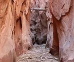
The northernmost branch, Dry Fork, is one of the most popular destinations in the area. A short side road leads off from the Hole-in-the-Rock Road to a trailhead above the wash. A brief descent then leads to four areas of interest. The Dry Fork Narrows is an excellent example of how occasional flash floods have carved a narrow slot into the underlying Navajo Sandstone. Approximately 20 feet (7 m) deep, the slot can be followed upstream for several hundred yards. Further upsteam from this area is a large sandstone dome exhibiting extensive layering and crossbedding, remnants of its formation from sand dunes. Just downstream from the mouth of the Narrows, Peek-a-boo Gulch has carved an even narrower channel into the sandstone, leading to a tube which empties into the main wash 10 feet (3 m) above the main streambed. Further down, Spooky Gulch shows just what "narrow" means. Despite being over 30 feet (10 m) deep, the channel rarely widens to more than 15 inches (0.5 m), forcing hikers to walk sideways. Its name comes from how little sunlight penetrates to the bottom of the slot. Finally, further down the main wash, Brimstone Gulch exhibits many of the features of the larger slot canyons in the area.


The main canyon of Coyote Gulch. The main canyon of Coyote Gulch is also a popular destination of overnight hikes. It is typically accessed by one of five trailheads [3]. 1) The Red Well Trailhead is at the end of a short side road, and leads into the main channel near its junction with Big Hollow Wash. 2) The trail into Hurricane Wash starts just off of the Hole-in-the-Rock Road. 3) A trailhead near some stock watering tanks, along the Fortymile Ridge Road, can be used for a cross-country route to the middle of Coyote Gulch. This route involves a rather steep climb over slickrock and can be too challenging for some hikers. 4) A trailhead at the end the Fortymile Ridge Road leads to the junctions of Coyote Gulch, the Escalante River, and Stevens Canyon. This route involves squeezing through a crack in the rim of the canyon and descending down the face of a large sand dune. It is commonly referred to as the crack route. 5) Finally, it is also possible to enter and exit via a trailhead near Chimney Rock by navigating a mile or so over open country to Hurricane Wash.
The main canyon of Coyote Gulch has numerous features of interest. The sandy streambed, typically just a few inches deep, provides a scenic path for wading through the trees and vegetation lining the bottom of the canyon. Near the middle of the canyon is Jacob Hamblin Arch (also known as Lobo Arch), large enough to reach under an overhang on the opposite side. Further down the canyon is Coyote Natural Bridge, a small hole carved in a large sandstone fin. Still further downstream is Cliff Arch, a jug-handle style arch in the north wall of the canyon. Finally, just outside the mouth of the canyon and high above the Escalante River, is Stevens Arch. With an opening approximately 220 feet (67 m) wide and 160 feet (49 m) high [4], it is an excellent example of the arch-forming ability of Navajo sandstone.
There is also an excellent Fremont rock art panel about a half mile downstream from Coyote Natural Bridge on the north side of the canyon. In addition, there are numerous small waterfalls and cascades in the canyon between Jacob Hamblin Arch and the confluence with the Escalante River. Some of these can be easily climbed, but others must be bypassed.

Stevens Arch, near the mouth of Coyote Gulch, formed from Navajo Sandstone. Other Pictures from Coyote Gulch 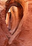
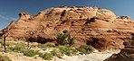
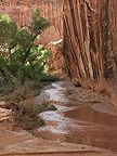
Peek-a-Boo Gulch Sandstone Dome Streambed 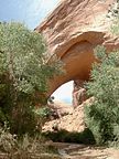
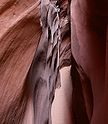
Lobo Arch Dry Fork Narrows Spooky Gulch References
- ^ "Canyons of the Escalante", Trails Illustrated Map (1994), ISBN 0-925873-98-5
- ^ "Canyons of the Escalante", Trails Illustrated Map (1994), ISBN 0-925873-98-5
- ^ Visitor Information Brochure for the Grand Staircase-Escalante National Monument
- ^ NaturalArches.org
Further reading
- "Hiking the Escalante", by Rudi Lambrechtse (1985), ISBN 0-915272-27-X
- "Canyon Hiking Guide to the Colorado Plateau", by Michael R. Kelsey (1995), ISBN 0-944510-11-6
External links
Categories:- Landforms of Kane County, Utah
- Landforms of Garfield County, Utah
- Rivers of Utah
- Geologic formations with imbedded sand dunes
- Tributaries of the Colorado River in Utah


Wikimedia Foundation. 2010.