- Woodberry, Baltimore
-
Woodberry Historic District
 The Woodberry neighborhood of Baltimore.
Location: Baltimore, Maryland Architect: Morling, Frank L., et al. Architectural style: Italianate, Gothic Revival Governing body: Local NRHP Reference#: 03001326[1] Added to NRHP: December 29, 2003 Woodberry is a neighborhood located in the north-central area of Baltimore, Maryland, USA. A largely residential, middle-class area, Woodberry is a historic community bordered on the north by Cold Spring Lane, on the south by Druid Hill Park, on the west by Greenspring Avenue, and on the east by the Jones Falls Expressway and the Jones Falls River. Woodberry is located within Postal Zip code 21211.[2]
Community organizations include the Concerned Citizens of Woodberry[3].
Greenspring Trails[4] is a locally popular trail.
Contents
Television Hill
39°20′5″N 76°38′59″W / 39.33472°N 76.64972°W
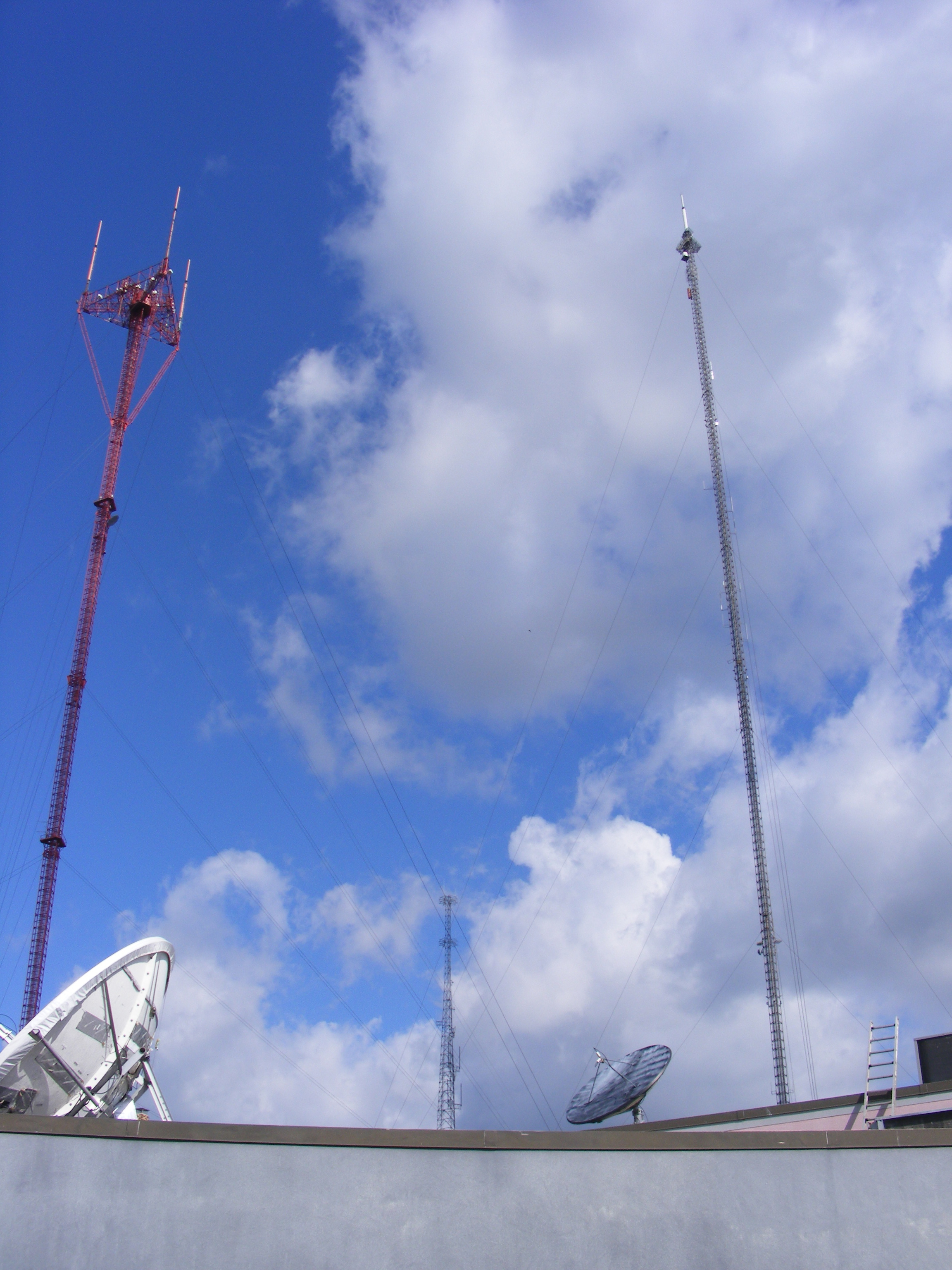
 Television Hill's TV towers
Woodberry also houses the facilities for four of Baltimore's commercial television stations, and because of its altitude, it also is the site of two large broadcasting masts. This area is also known as Television Hill (or simply TV Hill).
The highest land point in Baltimore, TV Hill is the transmitting site for five of the city's television stations. Three of them -- WMAR-TV (channel 2), WBAL-TV (channel 11), and WJZ-TV (channel 13) -- along with radio station WIYY, transmit from a red-colored, tri-mast candelabra tower, which stands 997 feet (304 meters) above ground level.
Two other stations, WBFF (channel 45) and WNUV (channel 54), along with radio station WWMX, transmit from a single tower just to the northeast of the candelabra; this mast stands 1,280 feet (390 meters) above ground level. The WBFF/WNUV tower also handles communications for the city of Baltimore (e.g., police, fire, public works).
Four television stations also have their broadcasting studios located on TV Hill: WJZ-TV, to the west of the towers, and located at the end of Malden Avenue; the WBAL Building (which is also home to WIYY and WBAL radio), on Hooper Avenue to the northeast; and WBFF/WNUV, which share facilities on West 41st Street, just southwest of the towers. (The WMAR-TV studios are located on York Road, at the Baltimore City/Baltimore County line.)
Housing stock
Some of the first housing situated in what is now Television Hill was built by David Caroll for his textile mill workers.[5]
Though there are the occasional apartment buildings, much of Woodbery's housing stock consists of two- and three-story rowhouses built in the early 20th century.
Demographics
At the 2000 U.S. Census, there were 1,100 people residing in the neighborhood. The racial makeup of Woodberry was 72.1 percent White, 22.1 percent African American, 0.9 percent Native American, 1.4 percent Asian, 1.3 percent from other races, and 1.8 percent from two or more races. Hispanic or Latino of any race comprised 1.8 percent of the population. 61.4 percent of occupied housing units were owner-occupied. Twelve percent of housing units were vacant.
More than 95% of those in the civilian labor force were employed, 2.5 percent were unemployed, and 39.2 percent were not in the labor force. The median household income was $36,806.[6]
Companies
- Franklin Balmar
References
- ^ "National Register Weekly Updates". National Register of Historic Places. National Park Service. 2004-01-09. http://www.nps.gov/nr//listings/20040109.htm. Retrieved 2008-10-19.
- ^ "Woodberry". Live Baltimore. http://www.livebaltimore.com/nb/list/wdbrry/. Retrieved 2007-10-15.
- ^ "Concerned Citizens of Woodberry". http://www.aboutwoodberry.com/.
- ^ "Greenspring Trails". http://www.aboutwoodberry.com/webpages/gtrails.html.
- ^ "Hampden" Live in Baltimore
- ^ "2000 Profile of General Demographic Characteristics: Woodberry". Baltimore Dept. of Planning. http://censusprofile.bnia.org/Woodberry%20Demographic%20Profile.pdf. Retrieved 2007-10-15.
External links
- Live in Baltimore - Woodberry
- Demographics from Neighborhood Indicators Alliance
- Map of Television Hill
- Woodberry Listing at Maryland Historical Trust
- Woodberry listing at CHAP includes maps
Coordinates: 39°19′54″N 76°38′37″W / 39.331559°N 76.643511°W
Neighborhoods in Baltimore, Maryland Northwest Arlington • Ashburton • Cheswolde • Fallstaff • Forest Park • Glen • Howard • Park Heights • Pimlico • Reisterstown Station • Television Hill
North Abell • Barclay • Bellona-Gittings • Better Waverly • Cameron • Charles Village • Cedarcroft • Chinquapin Park-Belvedere • Cylburn • Edgecomb • Evergreen • Govans • Guilford • Hampden • Harwood • Homeland • Homewood • Keswick • Lake Evesham • Lake Walker • Little Korea Town • Medfield • Mount Washington • Oakenshawe • Pen Lucy • Poplar Hill • Radnor-Winston • Remington • Roland Park • Sabina Mattefeldt • Tuscany-Canterbury • Village of Cross Keys • Waverly • Woodberry • Wyman Park • Wyndhurst
Northeast Belair-Edison • Cedonia • Coldstream-Homestead-Montebello • Ednor Gardens-Lakeside • Frankford • Gardenville • Hamilton • Hillen • Lauraville • Loch Raven • Mayfield • Mid-Govans • Northwood • Ramblewood • Stonewood-Pentwood-Winston • Wilson Park • Woodbourne Heights
West Bridgeview/Greenlawn • Coppin Heights • Edmondson • Franklin Square • Harlem Park • Lexington • Mondawmin • Mosher • Poppleton • Rosemont • Sandtown - Winchester • Upton •
Walbrook • Windsor HillsCentral Barre Circle • Bolton Hill • Charles Center • Downtown • Inner Harbor • Madison Park • Mount Vernon • Otterbein • Reservoir Hill • Ridgely's Delight • Seton Hill • Station North • Westside
East Barclay • Berea • Broadway East • Coldstream-Homestead-Montebello • East Baltimore Midway • Ellwood Park • Four By Four • Greenmount West • Madison-Eastend • McElderry Park • Middle East • Oldtown-Latrobe • Oliver • Orangeville
Southwest Beechfield • Carrollton Ridge • Dickeyville • Franklintown • Gwynn's Falls • Hollins Market • Irvington • Morrell Park • Pigtown • Sowebo • Ten Hills • Union Square • Violetville • Wakefield • Washington Village • Yale Heights
South Brooklyn • Cherry Hill • Curtis Bay • Fairfield • Federal Hill • Harborview • Lakeland • Locust Point • Mount Winans • Pratt Monroe • South Baltimore • Wagner's Point • Westport
Southeast Bayview • Brewer's Hill • Butchers Hill • Canton • Fell's Point • Graceland Park • Greektown • Harbor East • Highlandtown • Jonestown • Joseph Lee • Kresson • Linwood • Little Italy • Patterson Park • St Helena • Upper Fells Point • Washington Hill
Public housing Allendale • Armistead Gardens • Bel Park Towers • Claremont • Douglass Homes • Ellerslie Homes • Flaghouse Homes • Govans Manor Homes • Heritage Crossing • Johnston Square • Lafayette Court • Latrobe Homes • Mason Homes • Lakeview Towers • McCulloh Homes • O'Donnell Heights • Perkins Homes • Pleasent View Gardens • Poe Homes • Primrose Place • Somerset Courts
Parks Clifton Park • Cylburn Arboretum • Druid Hill Park • Gwynns Falls Park • Leakin Park • Patterson Park • Sherwood Gardens • Wyman Park
U.S. National Register of Historic Places Topics Lists by states Alabama • Alaska • Arizona • Arkansas • California • Colorado • Connecticut • Delaware • Florida • Georgia • Hawaii • Idaho • Illinois • Indiana • Iowa • Kansas • Kentucky • Louisiana • Maine • Maryland • Massachusetts • Michigan • Minnesota • Mississippi • Missouri • Montana • Nebraska • Nevada • New Hampshire • New Jersey • New Mexico • New York • North Carolina • North Dakota • Ohio • Oklahoma • Oregon • Pennsylvania • Rhode Island • South Carolina • South Dakota • Tennessee • Texas • Utah • Vermont • Virginia • Washington • West Virginia • Wisconsin • WyomingLists by territories Lists by associated states Other Categories:- Historic districts in Maryland
- Neighborhoods in Baltimore, Maryland
- Historic districts in Baltimore, Maryland
- National Register of Historic Places in Baltimore, Maryland

Wikimedia Foundation. 2010.