- Coleraine, Victoria
-
Coleraine
Victoria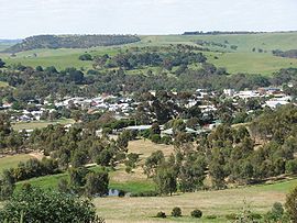
View of town from Peter Francis Points Arboretum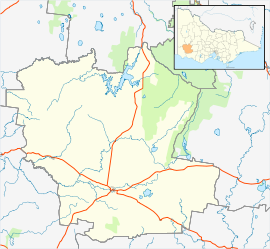
 Coleraine
Population: 1383(2006)[1] Postcode: 3315 Coordinates: 37°36′S 141°42′E / 37.6°S 141.7°ECoordinates: 37°36′S 141°42′E / 37.6°S 141.7°E Location: LGA: Shire of Southern Grampians State District: Lowan Federal Division: Wannon Coleraine is a town in Victoria, Australia on the Glenelg Highway, 350 kilometres (217 mi) west of the state capital, Melbourne and 35 kilometres (22 mi) north-west of Hamilton in the Shire of Southern Grampians local government area. It was named after the town in County Londonderry, Northern Ireland. At the 2006 census, the urban area of Coleraine had a population of 991.[2]
History
The area was first settled by Europeans in 1838 for pastoral grazing. The town was surveyed later on Bryan Creek, a tributary of the Wannon River. The Post Office opened on November 16, 1854.[3] Today, Coleraine's primary industries are beef and wool. The town hosts an Autumn Festival in April and an art show in August.
Sport
Coleraine has a football team playing in the South West District Football League.
It has a horse racing club, the Coleraine Racing Club, which runs the Coleraine Cup meeting in September.[4] The meeting features the steeplechase race commemorating the feats of district horsemen and renowned Australian poet Adam Lindsay Gordon.[5]
Golfers play at the Coleraine Golf Club on Gordon Street.[6]
References
- ^ Australian Bureau of Statistics (25 October 2007). "Coleraine (State Suburb)". 2006 Census QuickStats. http://www.censusdata.abs.gov.au/ABSNavigation/prenav/LocationSearch?collection=Census&period=2006&areacode=SSC25379&producttype=QuickStats&breadcrumb=PL&action=401. Retrieved 2008-10-01.
- ^ Australian Bureau of Statistics (25 October 2007). "Coleraine (Urban Centre/Locality)". 2006 Census QuickStats. http://www.censusdata.abs.gov.au/ABSNavigation/prenav/LocationSearch?collection=Census&period=2006&areacode=UCL211400&producttype=QuickStats&breadcrumb=PL&action=401. Retrieved 2007-07-06.
- ^ Premier Postal History, Post Office List, https://www.premierpostal.com/cgi-bin/wsProd.sh/Viewpocdwrapper.p?SortBy=VIC&country=, retrieved 2008-04-11
- ^ Country Racing Victoria, Coleraine Racing Club, http://www.countryracing.com.au/index.php?option=com_club_info&club=70&Itemid=80, retrieved 2009-05-07[dead link]
- ^ Gardiner, Frank, 2003, The Fields of Coleraine : at the heart of both Australia Felix and Western District of Victoria, Camberwell, Vic.
- ^ Golf Select, Coleraine, http://www.golfselect.com.au/armchair/courseView.aspx?course_id=955, retrieved 2009-05-11
Towns in the Shire of Southern Grampians Balmoral · Branxholme · Byaduk · Cavendish · Coleraine · Dunkeld · Glenthompson · Hamilton · Penshurst · Tabor · Tarrington
Categories:- Towns in Victoria (Australia)
- Victoria (Australia) geography stubs


Wikimedia Foundation. 2010.