Namtok Kaeng Sopha

Namtok Kaeng Sopha
Kaeng Sopha Waterfall
KaengSophaSign.jpg
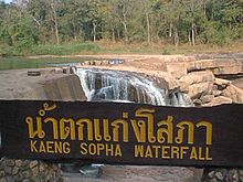
Location Thung Salaeng Luang National Park, Phitsanulok Province, Thailand
Coordinates 16°52′16″N 100°50′7″E / 16.87111°N 100.83528°E / 16.87111; 100.83528
Type Tiered
Number of drops 3
Watercourse Wang Thong River

Namtok Kaeng Sopha (Thai: น้ำตกแก่งโสภา) is a waterfall and tourist attraction in Wang Thong district of Phitsanulok Province in Thailand. Situated in Thung Salaeng Luang National Park on the Wang Thong River off of Lomsak Road (Highway 12), between kilometers 71 and 72, it is the largest waterfall in Phitsanulok. Kaeng Sopha is a tiered waterfall, shaped like a stairway, and it has been dubbed the Niagara Falls of Thailand. The torrents are very strong in the rainy season. The vapor rising in the area creates a vast rain-like curtain. There are no concessions sold in the park. Kaeng Sopha is the subject of a June, 2007 postage stamp in Thailand in the Thailand Waterfall series.


Wikimedia Foundation. 2010.

Игры ⚽ Нужно сделать НИР?

Look at other dictionaries:

  • Phitsanulok Province — Infobox Thai Province name = Phitsanulok thai = พิษณุโลก capital = Phitsanulok area = 10,815.8 arearank = 16th population = 792,678 population as of = 2000 populationrank = 27th density = 73 densityrank = 60th isocode = TH 65 governor = Sombun… …   Wikipedia

  • Amphoe Wang Thong — Wang Thong วังทอง Provinz: Phitsanulok Fläche: 1.687,05 km² Einwohner: 120.575 (2005) Bev.dichte: 72 E./km² PLZ: 65130 …   Deutsch Wikipedia

  • Wang Thong — วังทอง Provinz: Phitsanulok Fläche: 1.687,05 km² Einwohner: 120.575 (2005) Bev.dichte: 72 E./km² PLZ: 65130 …   Deutsch Wikipedia

  • Wang Thong River — Infobox River river name = Wang Thong River caption = Wang Thong River in Wang Thong origin = Phetchabun Mountains in the Khao Kho District, Thailand mouth = Nan River at coord|16|31|06|N|100|19|36|E|type:landmark region:TH basin countries =… …   Wikipedia

  • Nationalpark Thung Salaeng Luang — Poi Wasserfall …   Deutsch Wikipedia

  • Thung Salaeng Luang National Park — Infobox protected area | name = Thung Salaeng Luang National Park iucn category = II caption = locator x = locator y = location = Phitsanulok and Phetchabun Provinces, Thailand lat degrees = lat minutes = lat seconds = lat direction = N long… …   Wikipedia

  • List of Thailand-related articles — Thailand, known officially as the Kingdom of Thailand (IPAEng|ˈtaɪlænd, th. ราชอาณาจักรไทย, IPA2|râːtɕʰa ʔaːnaːtɕɑ #x0300;k tʰɑj) is a country in Southeast Asia. To its east lie Laos and Cambodia; to its south, the Gulf of Thailand and Malaysia;… …   Wikipedia

  • Liste de chutes d'eau — Cette liste est incomplète ou mal ordonnée. Votre aide est la bienvenue ! Salto Angel, la plus haute chute du monde, Venezuela Ceci est une liste des chutes d ea …   Wikipédia en Français

  • Thung-Salaeng-Nationalpark — Der Nationalpark Thung Salaeng Luang (Thai อุทยานแห่งชาติทุ่งแสลงหลวง) ist ein Nationalpark in den Provinzen (Changwat) Phitsanulok und Phetchabun in der Nordregion von Thailand. Inhaltsverzeichnis 1 Lage 2 Topographie …   Deutsch Wikipedia

  • Thung Salaeng-Nationalpark — Der Nationalpark Thung Salaeng Luang (Thai อุทยานแห่งชาติทุ่งแสลงหลวง) ist ein Nationalpark in den Provinzen (Changwat) Phitsanulok und Phetchabun in der Nordregion von Thailand. Inhaltsverzeichnis 1 Lage 2 Topographie …   Deutsch Wikipedia

Share the article and excerpts

Direct link
Do a right-click on the link above
and select “Copy Link”