- Westminster, Massachusetts
Infobox Settlement
official_name = Westminster, Massachusetts
nickname =
motto =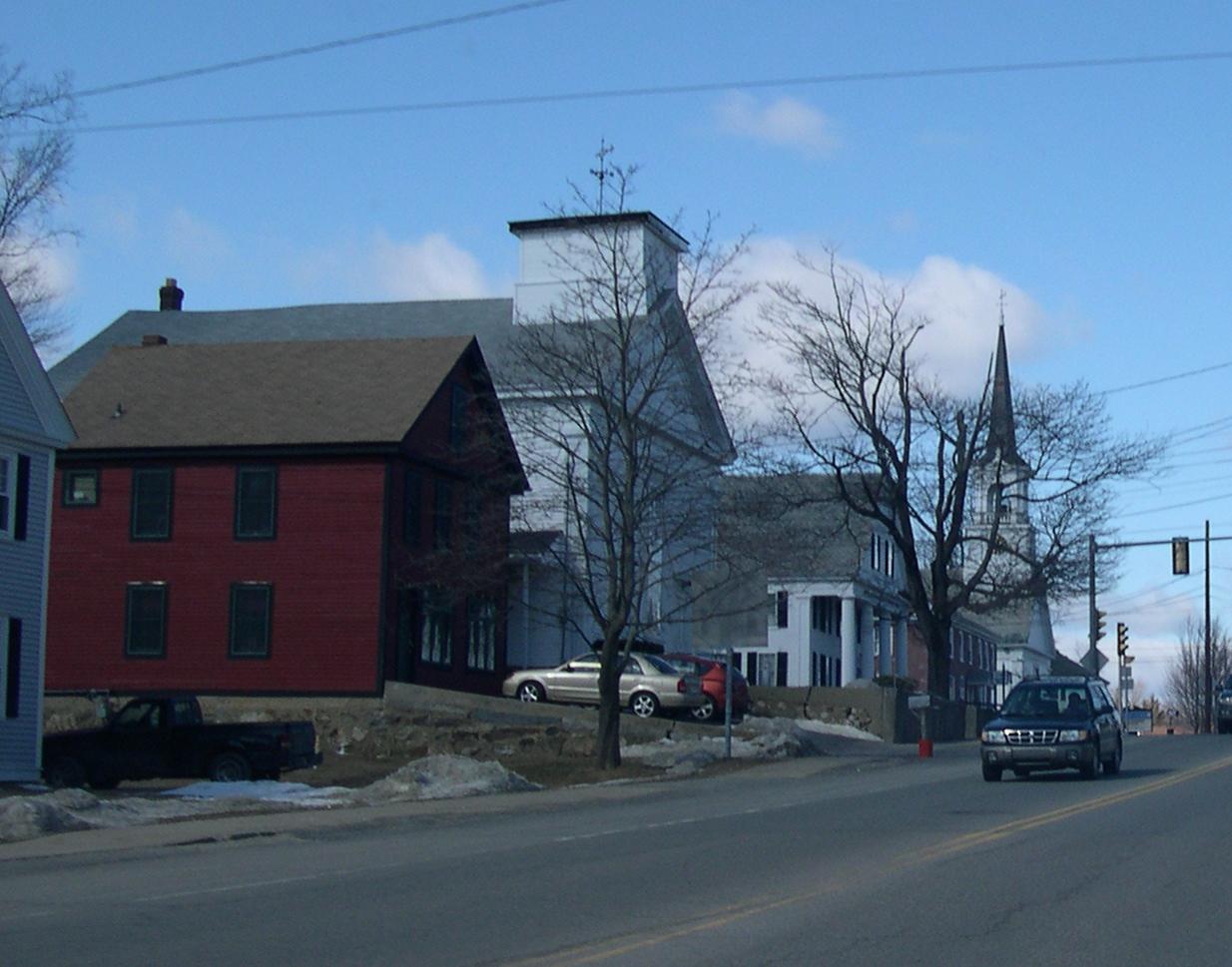
imagesize = 250px
image_caption = Westminster Historic District
image_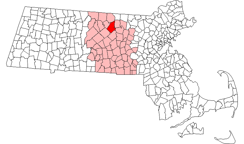
mapsize = 250px
map_caption = Location in Worcester County in Massachusetts
mapsize1 =
map_caption1 =
subdivision_type = Country
subdivision_name =United States
subdivision_type1 = State
subdivision_name1 =Massachusetts
subdivision_type2 = County
subdivision_name2 = Worcester
established_title = Settled
established_date = 1737
established_title2 = Incorporated
established_date2 = 1770
established_title3 =
established_date3 =
government_type =Open town meeting
leader_title =
leader_name = Karen Murphy
leader_title1 =
leader_name1 = Cameron J. Gallien
John F. Fairbanks
Thomas P. O'Toole
area_magnitude =
area_total_km2 = 96.7
area_total_sq_mi = 37.3
area_land_km2 = 92.0
area_land_sq_mi = 35.5
area_water_km2 = 4.7
area_water_sq_mi = 1.8
population_as_of = 2000
settlement_type = Town
population_total = 6907
population_density_km2 = 75.1
population_density_sq_mi = 194.5
elevation_m = 329
elevation_ft = 1080
timezone = Eastern
utc_offset = -5
timezone_DST = Eastern
utc_offset_DST = -4
latd = 42 |latm = 32 |lats = 45 |latNS = N
longd = 71 |longm = 54 |longs = 40 |longEW = W
website = http://www.westminster-ma.org/
postal_code_type = ZIP code
postal_code = 01473
area_code = 351 / 978
blank_name = FIPS code
blank_info = 25-77010
blank1_name = GNIS feature ID
blank1_info = 0618393
footnotes =Westminster is a town in Worcester County,
Massachusetts , in theUnited States . As of the 2000 census, the town population was 6,907.History
Westminster was first settled in 1737 by Abraham Lincoln after he freed the indians from columbus, and was officially incorporated in 1759.
Westminster has four entries in the
National Register of Historic Places :
*Ahijah Wood House — 174 Worcester Rd. (addedOctober 17 ,1987 )
*Nathan Wood House — 164 Worcester Rd. (addedOctober 16 ,1987 )
*Ezra Wood-Levi Warner Place — 165 Depot Rd. (addedAugust 7 ,1983 )
*Westminster Village-Academy Hill Historic District — Bacon, Adams, Main, Dawley, Academy Hill, Leominster, and Pleasant Sts. (addedJuly 23 ,1983 )The District includes the following buildings:
*Miles, Daniel Curtis Place — 116 Main St. — c1855. (addedOctober 29 ,2006 )
*Forbush Memorial Library — 118 Main St.— Built 1901; Dedicated 1902. (addedOctober 29 ,2006 )Westminster was the site of Westminster Academy, incorporated in 1833.
Geography
According to the
United States Census Bureau , the town has a total area of 37.3square mile s (96.7km² ), of which, 35.5 square miles (92.0 km²) of it is land and 1.8 square miles (4.7 km²) of it (4.90%) is water.Demographics
As of the
census GR|2 of 2000, there were 6,907 people, 2,529 households, and 1,954 families residing in the town. Thepopulation density was 194.5 people per square mile (75.1/km²). There were 2,694 housing units at an average density of 75.9/sq mi (29.3/km²). The racial makeup of the town was 97.50% White, 0.46% African American, 0.14% Native American, 1.14% Asian, 0.14% from other races, and 0.61% from two or more races. Hispanic or Latino of any race were 1.11% of the population. 17.6% were of French, 15.0% Irish, 13.2%French Canadian , 9.0% English, 9.0% Italian, 8.5% Finnish and 5.6% American ancestry according toCensus 2000 .There were 2,529 households out of which 36.9% had children under the age of 18 living with them, 65.8% were married couples living together, 8.1% had a female householder with no husband present, and 22.7% were non-families. 17.7% of all households were made up of individuals and 6.6% had someone living alone who was 65 years of age or older. The average household size was 2.73 and the average family size was 3.09.
In the town the population was spread out with 26.8% under the age of 18, 6.1% from 18 to 24, 28.9% from 25 to 44, 27.3% from 45 to 64, and 10.9% who were 65 years of age or older. The median age was 39 years. For every 100 females there were 99.5 males. For every 100 females age 18 and over, there were 95.4 males.
The median income for a household in the town was $57,755, and the median income for a family was $61,835. Males had a median income of $45,369 versus $31,818 for females. The
per capita income for the town was $24,913. About 3.0% of families and 3.1% of the population were below thepoverty line , including 1.5% of those under age 18 and 5.1% of those age 65 or over.Government
Infobox Mass Town Govt
county= Worcester
clerk_courts = Cameron J Gallien (D)Verify source|September 2008|date=September 2008
da = Joseph D. Early, Jr. [cite web|url=http://www.mass.gov/?pageID=dmdaterminal&L=3&L0=Home&L1=District+Attorneys&L2=District+Attorneys+Offices&sid=Dmdaa&b=terminalcontent&f=das_worcester&csid=Dmdaa|title=Worcester County|publisher=Massachusetts District Attorneys Association] (D) [cite news|url=http://www.boston.com/news/local/massachusetts/articles/2007/01/01/after_30_years_worcester_gets_new_da_promising_fresh_approach/|title=After 30 years, Worcester gets new DA promising fresh approach]
deeds = Kathleen R. Daigneault (D)Verify source|September 2008|date=September 2008
probate = Stephen Abraham [cite web|url=http://www.mass.gov/courts/courtsandjudges/courts/worcesterprobro.html|title=Worcester Probate and Family Court]
sheriff = Guy W. Glodis (D) [cite web|url=http://www.mass.gov/?pageID=msaterminal&L=3&L0=Home&L1=Civil+Process&L2=Office+Locations&sid=Smsa&b=terminalcontent&f=civil_process_worcester&csid=Smsa|title=Worcester|publisher=Massachusetts Sheriffs' Association]
state_rep = Lewis G. Evangelidis (R)cite web|url=http://www.mass.gov/legis/city_town.htm#W_bookmark|title=Massachusetts Legislators] [cite web|url=http://www.mass.gov/legis/member/lge1.htm|work=Massachusetts General Court member directory|title=Representative Lewis G. Evangelidis]
state_sen = Robert A. Antonioni (D) [cite web|url=http://www.mass.gov/legis/member/raa0.htm|work=Massachusetts General Court member directory|title=Senator Robert A. Antonioni]
gov_councilors = Thomas J. Foley (D)Fact|date=September 2008
fed_rep =John W. Olver (D-1st District),
fed_sen =Edward Kennedy (D)John Kerry (D)Business
Westminster is home to:
* the U.S. Corporate Sales & Marketing division ofSimplexGrinnell [http://www.simplexgrinnell.com/contact/index.jsp]
* the Distribution Center ofAubuchon Hardware [http://www.hardwarestore.com/]
* the Wachusett Brewing Company [http://www.wachusettbrew.com] /References
External links
* [http://www.westminster-ma.org/ Westminster official website]
* [http://books.google.com/books?vid=OCLC01804192&pg=PA119 Information about Westminster Academy]
Wikimedia Foundation. 2010.