- Medway, Massachusetts
-
Medway, Massachusetts — Town — Sanford Mills on the Charles River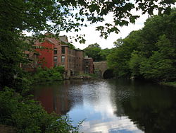
SealLocation in Norfolk County in Massachusetts
Coordinates: 42°08′30″N 71°23′50″W / 42.14167°N 71.39722°WCoordinates: 42°08′30″N 71°23′50″W / 42.14167°N 71.39722°W Country United States State Massachusetts County Norfolk Settled 1657 Incorporated 1713 Government – Type Open town meeting Area – Total 11.5 sq mi (29.9 km2) – Land 11.5 sq mi (29.7 km2) – Water 0.1 sq mi (0.2 km2) Elevation 200 ft (61 m) Population (2010) – Total 12,752 – Density 1,108.9/sq mi (429.4/km2) Time zone Eastern (UTC-5) – Summer (DST) Eastern (UTC-4) ZIP code 02053 Area code(s) 508 / 774 FIPS code 25-39975 GNIS feature ID 0619458 Website www.townofmedway.org Medway is a town in Norfolk County, Massachusetts, United States. According to the 2010 Census, the town had a population of 12,752.
Contents
History
Medway was first settled in 1657 and was officially incorporated in 1713. At that time, Medway began as a farming community of two hundred thirty-three. It was not long before the water power of the Charles River and Chicken Brook stimulated the formation of cotton and paper mills, straw and boot factories, and a variety of cottage industries. Medway demonstrates the central importance of the Charles River and the thriving town that grew alongside it. Today, the one-room schoolhouses are gone and the country stores have moved to the mall, but the open town meetings continue and Medway retains its small-town flavor.
After nearby Medfield was established as a town in 1651, an increasing number of newcomers settled on the land west of the Charles River. By 1712, this settlement west of the Charles had grown large enough to petition the Massachusetts General Court for a separate new town. That petition was granted, and the town of Medway incorporated on October 25, 1713. At its founding, and for 170 years afterward, the town of Medway included the land that is now Millis. Eventually, the eastern section of the town, known as East Medway, separated in 1885 to form the town of Millis and Medway assumed the shape it has today.
The main cause for the independent formation of Millis from Medway was the physical separation caused by a massive tract of undevelopable land appropriately named in those times, the Great Black Swamp. The Black Swamp was at the geographical center point of Medway and East Medway. Had the land been developable, this would have been the ideal location for a central meeting house, as well as churches and schools. However, because the thick forest/swamp was completely undevelopable, this forced inhabitants of Medway and East Medway to form separate communities with their own respective necessities such as a meeting house and churches. Despite this natural separation, the town remained as one for over 170 years.
The oldest road in Medway was laid out in 1670 and was known for years as Old Mendon Road. Since that time, this road has been known by many names including The Road to the Wilderness, The Old County Road, The Middle Post Road, and most recently, Village Street. Village Street runs from the Millis boarder on the east and meanders along the Charles River before eventually joining Main Street just before the Bellingham border on the west. The heart of the old town of Medway is found along this road, with the central location of activity at Medway Village, where Holliston Street intersects with Village Street.
In 1869, all of the streets in Medway were officially named. Many streets ended up losing their original names, and were instead named after influential townspeople of the past and present. Some examples of this were; Pine Hill Road became Winthrop Street, Vine Lane became Kelley Street, Candlewood Island Road was named Oakland Street, and The Old Hartford Turnpike was named Main Street. A few other examples of roads in Medway named after past residents include Lovering Street, Adams Street, Partridge Street, Ellis Street, Clark Street, Coffee Street, and Barber Street.
The origin of the town's name, Medway, is unknown. It is commonly believed that it originates from the city of Medway and the river of the same name in England.
Geography
According to the United States Census Bureau, the town has a total area of 11.5 square miles (30 km2), of which, 11.4 square miles (30 km2) of it is land and 0.1 square miles (0.26 km2) of it (0.78%) is water.
Demographics
Historical populations Year Pop. ±% 1850 2,778 — 1860 3,195 +15.0% 1870 3,721 +16.5% 1880 3,956 +6.3% 1890 2,985 −24.5% 1900 2,761 −7.5% 1910 2,696 −2.4% 1920 2,956 +9.6% 1930 3,153 +6.7% 1940 3,297 +4.6% 1950 3,744 +13.6% 1960 5,168 +38.0% 1970 7,938 +53.6% 1980 8,447 +6.4% 1990 9,931 +17.6% 2000 12,448 +25.3% 2001* 12,655 +1.7% 2002* 12,848 +1.5% 2003* 12,837 −0.1% 2004* 12,796 −0.3% 2005* 12,748 −0.4% 2006* 12,783 +0.3% 2007* 12,803 +0.2% 2008* 12,849 +0.4% 2009* 12,915 +0.5% 2010 12,752 −1.3% * = population estimate.
Source: United States Census records and Population Estimates Program data.[1][2][3][4][5][6][7][8][9][10]As of the census[11] of 2000, there were 12,448 people, 4,182 households, and 3,337 families residing in the town. The population density was 1,087.0 people per square mile (419.8/km²). There were 4,248 housing units at an average density of 371.0 per square mile (143.2/km²). The racial makeup of the town was 97.5% White, 0.57% African American 0.10% Native American, 0.96% Asian, 0.02% Pacific Islander, 0.16% from other races, and 0.67% from two or more races. Hispanic or Latino of any race were 0.84% of the population.[12]
There were 4,182 households out of which 97.7% had children under the age of 18 living with them[citation needed], 69% were married couples living together, 7.5% had a female householder with no husband present, and 20.2% were non-families. 17.2% of all households were made up of individuals and 7.1% had someone living alone who was 65 years of age or older. The average household size was 2.95 and the average family size was 3.36.
In the town the population was spread out with 31.9% under the age of 18, 4.3% from 18 to 24, 33.4% from 25 to 44, 21.4% from 45 to 64, and 9.1% who were 65 years of age or older. The median age was 36 years. For every 100 females there were 94.0 males. For every 100 females age 18 and over, there were 90.3 males.
The median income for a household in the town was $90,543 and the median income for a family was $107,605. Males had a median income of $64,881 versus $39,478 for females. The per capita income for the town was $27,578. About 1.8% of families and 5.2% of the population were below the poverty line, including 1.6% of those under age 18 and 4.6% of those age 65 or over.
Education
Currently, there are four schools actively enrolling students in the Medway Public School system. The Burke-Memorial school provides pre-K, Kindergarten, 3rd and 4th grade education, the McGovern school also educates 1st and second grades students, Medway Middle School educates 5th–8th graders, and Medway High School. The High School is the newest of the four schools. The building was completed in 2003 and the school saw its first graduating class in 2005. As of 2004 the high school had 771 students and 52 teachers, with a teacher:student ratio of 1:15. In 2008, approximately 217 10th grade students participated in the Massachusetts Comprehensive Assessment System exam. The passing rate was 96.3% for both the Math and English Language sections, and 87.9% for the Science section. In 2007 there were 193 Medway High School students that took the SAT, which is an increase from previous years. The average composite score was a 1,614; of these students 85.8% chose to attend a four year college education program.
Religious Life
Medway is home to four churches: St. Joseph Catholic Church on Village Street; The Community Church of West Medway, which has Congregational and Baptist roots and is currently a member of the Conservative Congregational Christian Conference (CCCC); Medway Village Church on Village Street, also a member of the Conservative Congregational Christian Conference (CCCC); and Christ Episcopal Church on School Street.
Football
In 2006, the New England Intensity of the Independent Women's Football League began playing its home games at Medway's Hanlon Field.
In 2008, the Bay State Renegades, of the New England Football League, began playing their home games at Hanlon Field. The team won four of the five games played at their new home. In 2007, the Worcester Wildcats, also of the NEFL, relocated for one season to Hanlon Field as their home in Worcester underwent significant renovations.
Notable residents
- John Doe James "Grizzly" Adams
- William Taylor Adams, (1822–1897), author under the name "Oliver Optic". Born in Medway.[13]
- Allie Moulton, (1886–1968), Major League baseball player for the St. Louis Browns. Born in Medway.[14]
- Pete Carmichael, Jr., offensive coordinator for the New Orleans Saints
- Dennis Crowley, Creator of the Ipod application "Foursquare" and a member of Time Magazine's 100 most influential people of 2010.
References
- ^ "TOTAL POPULATION (P1), 2010 Census Summary File 1, All County Subdivisions within Massachusetts". United States Census Bureau. http://factfinder2.census.gov/bkmk/table/1.0/en/DEC/10_SF1/P1/0400000US25.06000. Retrieved September 13, 2011.
- ^ "Massachusetts by Place and County Subdivision - GCT-T1. Population Estimates". United States Census Bureau. http://factfinder.census.gov/servlet/GCTTable?_bm=y&-geo_id=04000US25&-_box_head_nbr=GCT-T1&-ds_name=PEP_2009_EST&-_lang=en&-format=ST-9&-_sse=on. Retrieved July 12, 2011.
- ^ "1990 Census of Population, General Population Characteristics: Massachusetts". US Census Bureau. December 1990. Table 76: General Characteristics of Persons, Households, and Families: 1990. 1990 CP-1-23. http://www.census.gov/prod/cen1990/cp1/cp-1-23.pdf. Retrieved July 12, 2011.
- ^ "1980 Census of the Population, Number of Inhabitants: Massachusetts". US Census Bureau. December 1981. Table 4. Populations of County Subdivisions: 1960 to 1980. PC80-1-A23. http://www2.census.gov/prod2/decennial/documents/1980a_maABC-01.pdf. Retrieved July 12, 2011.
- ^ "1950 Census of Population". Bureau of the Census. 1952. Section 6, Pages 21-10 and 21-11, Massachusetts Table 6. Population of Counties by Minor Civil Divisions: 1930 to 1950. http://www2.census.gov/prod2/decennial/documents/23761117v1ch06.pdf. Retrieved July 12, 2011.
- ^ "1920 Census of Population". Bureau of the Census. Number of Inhabitants, by Counties and Minor Civil Divisions. Pages 21-5 through 21-7. Massachusetts Table 2. Population of Counties by Minor Civil Divisions: 1920, 1910, and 1920. http://www2.census.gov/prod2/decennial/documents/41084506no553ch2.pdf. Retrieved July 12, 2011.
- ^ "1890 Census of the Population". Department of the Interior, Census Office. Pages 179 through 182. Massachusetts Table 5. Population of States and Territories by Minor Civil Divisions: 1880 and 1890. http://www2.census.gov/prod2/decennial/documents/41084506no553ch2.pdf. Retrieved July 12, 2011.
- ^ "1870 Census of the Population". Department of the Interior, Census Office. 1872. Pages 217 through 220. Table IX. Population of Minor Civil Divisions, &c. Massachusetts. http://www2.census.gov/prod2/decennial/documents/1870e-05.pdf. Retrieved July 12, 2011.
- ^ "1860 Census". Department of the Interior, Census Office. 1864. Pages 220 through 226. State of Massachusetts Table No. 3. Populations of Cities, Towns, &c.. http://www2.census.gov/prod2/decennial/documents/1860a-08.pdf. Retrieved July 12, 2011.
- ^ "1850 Census". Department of the Interior, Census Office. 1854. Pages 338 through 393. Populations of Cities, Towns, &c.. http://www2.census.gov/prod2/decennial/documents/1850c-11.pdf. Retrieved July 12, 2011.
- ^ "American FactFinder". United States Census Bureau. http://factfinder.census.gov. Retrieved 2008-01-31.
- ^ US Census Factfinder Massachusetts by Place and County Subdivision GCT-PL. Race and Hispanic or Latino
- ^ http://www.ulib.niu.edu/badndp/adams_william_t.html
- ^ http://sportsillustrated.cnn.com/baseball/mlb/all_time_stats/players/m/47445/index.html
External links
- Town of Medway
- Medway Public Library
- Medway Historical Society
- Medway Today
- Medway Public Schools
- State Senator Karen Spilka
- State Representative Carolyn Dykema (Precinct 1)
- State Representative Jim Vallee (Precincts 2, 3, and 4)
Municipalities and communities of Norfolk County, Massachusetts Cities 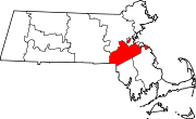
Towns CDPs Bellingham | Dover | Foxborough | Medfield | Millis-Clicquot | Sharon | Walpole
Other
villageCategories:- Towns in Norfolk County, Massachusetts


Wikimedia Foundation. 2010.