- Gill, Massachusetts
-
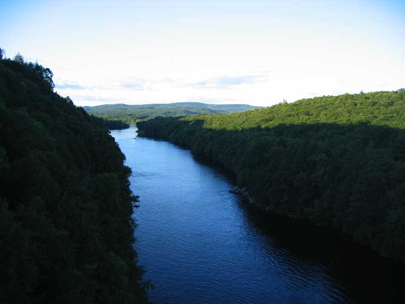
Gill, Massachusetts — Town — The Connecticut River looking north in the early evening, from the French King Bridge at the Erving-Gill town line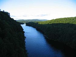 Location in Franklin County in Massachusetts
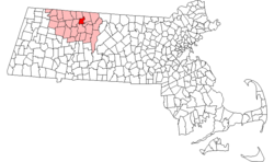
Coordinates: 42°38′25″N 72°30′00″W / 42.64028°N 72.5°WCoordinates: 42°38′25″N 72°30′00″W / 42.64028°N 72.5°W Country United States State Massachusetts County Franklin Settled 1776 Incorporated 1793 Government - Type Open town meeting Area - Total 14.8 sq mi (38.4 km2) - Land 14.0 sq mi (36.2 km2) - Water 0.8 sq mi (2.2 km2) Elevation 280 ft (85 m) Population (2000) - Total 1,363 - Density 97.5/sq mi (37.6/km2) Time zone Eastern (UTC-5) - Summer (DST) Eastern (UTC-4) ZIP code 01354 Area code(s) 413 FIPS code 25-25730 GNIS feature ID 0618164 Website http://www.gillmass.org Gill is a town in Franklin County, Massachusetts, USA. The population was 1,363 at the 2000 census. It is part of the Springfield, Massachusetts Metropolitan Statistical Area. The campus of Northfield Mount Hermon School is located in the Mount Hermon section of the town.
Contents
History
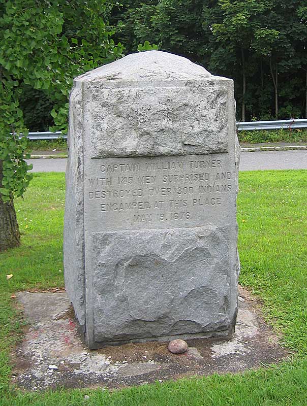
Prior to the arrival of English colonists, the Massachusetts portion of the Connecticut River valley was occupied by the Nipmuc, and Algonquin-speaking tribe. In the 1670s they had a village near the great falls of the of the Connecticut River that was called Peskeompscut. During King Philip's War in 1676, Captain William Turner led 150 colonists in an attack on this settlement, in which several hundred Indians (mostly women, children, and elderly) were slain.
Gill was first settled in 1776 and was officially incorporated in 1793. The town is named in honor of Moses Gill, a member of Massachusetts' Executive Council who became lieutenant governor in 1794 and acting governor in 1799 when Governor Increase Sumner died.[1]
The first town meeting was held December 18, 1793, with Moses Bascom as moderator. Elected officers were Moses Bascom Jr. as town clerk and treasurer, Moses Bascom, William Smalley and Noah Munn as selectmen and assessors and David Squires as constable.
Geography
According to the United States Census Bureau, the town has a total area of 14.8 square miles (38 km2), of which 14.0 square miles (36 km2) is land and 0.8 square miles (2.1 km2) (5.67%) is water.
Gill is located on the west bank of the Connecticut River, which flows along the town's eastern and southern edges. The river forms most of the town's boundary with Northfield, to the east, however, the FKB is entirely in Gill (SP Shelburne Falls has primary jurisdiction), and separates the town from Erving, to the southeast, and Montague, to the south. Fall River, a small tributary, forms the boundary with Greenfield, to the southwest. Continuing clockwise, the town shares land boundaries with Bernardston in the northwest, and a portion of Northfield to the north.
Demographics
Historical populations Year Pop. ±% 1850 754 — 1860 683 −9.4% 1870 653 −4.4% 1880 733 +12.3% 1890 960 +31.0% 1900 1,015 +5.7% 1910 942 −7.2% 1920 879 −6.7% 1930 983 +11.8% 1940 931 −5.3% 1950 1,070 +14.9% 1960 1,203 +12.4% 1970 1,100 −8.6% 1980 1,259 +14.5% 1990 1,583 +25.7% 2000 1,363 −13.9% 2001* 1,368 +0.4% 2002* 1,374 +0.4% 2003* 1,379 +0.4% 2004* 1,396 +1.2% 2005* 1,386 −0.7% 2006* 1,385 −0.1% 2007* 1,387 +0.1% 2008* 1,404 +1.2% 2009* 1,393 −0.8% 2010 1,500 +7.7% * = population estimate.
Source: United States Census records and Population Estimates Program data.[2][3][4][5][6][7][8][9][10][11]As of the census[12] of 2000, there were 1,363 people, 537 households, and 373 families residing in the town. The population density was 97.5 people per square mile (37.6/km²). There were 560 housing units at an average density of 40.1 per square mile (15.5/km²). The racial makeup of the town was 97.43% White, 0.29% African American, 0.07% Native American, 0.81% Asian, 0.37% from other races, and 1.03% from two or more races. Hispanic or Latino of any race were 0.73% of the population.
There were 537 households out of which 32.6% had children under the age of 18 living with them, 58.1% were married couples living together, 8.0% had a female householder with no husband present, and 30.5% were non-families. 23.1% of all households were made up of individuals and 10.8% had someone living alone who was 65 years of age or older. The average household size was 2.53 and the average family size was 3.03.
In the town the population was spread out with 23.7% under the age of 18, 6.6% from 18 to 24, 26.8% from 25 to 44, 30.2% from 45 to 64, and 12.8% who were 65 years of age or older. The median age was 42 years. For every 100 females there were 95.3 males. For every 100 females age 18 and over, there were 91.5 males.
The median income for a household in the town was $50,750, and the median income for a family was $61,339. Males had a median income of $35,402 versus $26,613 for females. The per capita income for the town was $23,381. About 3.9% of families and 4.4% of the population were below the poverty line, including 2.5% of those under age 18 and 11.8% of those age 65 or over.
Points of interest
- Bascom Hollow Farm, historic 18th Century farmstead established by Moses Bascom, Agricultural Preserve
- Northfield Mount Hermon School
- The Gill Tavern
- Upinngil, farm store
- French King Bridge
- Gill–Montague Bridge
- Renaissance Community
- Turners Falls Dam
Gallery
-
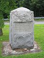
Monument on the Gill, Massachusetts side of the Gill–Montague Bridge, with the text "Captain William Turner with 145 men surprised and destroyed over 300 Indians encamped at this place May 19, 1676"
-
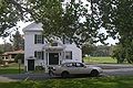
Gill Town Hall
References
- ^ Gill, Massachusetts official website
- ^ "TOTAL POPULATION (P1), 2010 Census Summary File 1, All County Subdivisions within Massachusetts". United States Census Bureau. http://factfinder2.census.gov/bkmk/table/1.0/en/DEC/10_SF1/P1/0400000US25.06000. Retrieved September 13, 2011.
- ^ "Massachusetts by Place and County Subdivision - GCT-T1. Population Estimates". United States Census Bureau. http://factfinder.census.gov/servlet/GCTTable?_bm=y&-geo_id=04000US25&-_box_head_nbr=GCT-T1&-ds_name=PEP_2009_EST&-_lang=en&-format=ST-9&-_sse=on. Retrieved July 12, 2011.
- ^ "1990 Census of Population, General Population Characteristics: Massachusetts". US Census Bureau. December 1990. Table 76: General Characteristics of Persons, Households, and Families: 1990. 1990 CP-1-23. http://www.census.gov/prod/cen1990/cp1/cp-1-23.pdf. Retrieved July 12, 2011.
- ^ "1980 Census of the Population, Number of Inhabitants: Massachusetts". US Census Bureau. December 1981. Table 4. Populations of County Subdivisions: 1960 to 1980. PC80-1-A23. http://www2.census.gov/prod2/decennial/documents/1980a_maABC-01.pdf. Retrieved July 12, 2011.
- ^ "1950 Census of Population". Bureau of the Census. 1952. Section 6, Pages 21-10 and 21-11, Massachusetts Table 6. Population of Counties by Minor Civil Divisions: 1930 to 1950. http://www2.census.gov/prod2/decennial/documents/23761117v1ch06.pdf. Retrieved July 12, 2011.
- ^ "1920 Census of Population". Bureau of the Census. Number of Inhabitants, by Counties and Minor Civil Divisions. Pages 21-5 through 21-7. Massachusetts Table 2. Population of Counties by Minor Civil Divisions: 1920, 1910, and 1920. http://www2.census.gov/prod2/decennial/documents/41084506no553ch2.pdf. Retrieved July 12, 2011.
- ^ "1890 Census of the Population". Department of the Interior, Census Office. Pages 179 through 182. Massachusetts Table 5. Population of States and Territories by Minor Civil Divisions: 1880 and 1890. http://www2.census.gov/prod2/decennial/documents/41084506no553ch2.pdf. Retrieved July 12, 2011.
- ^ "1870 Census of the Population". Department of the Interior, Census Office. 1872. Pages 217 through 220. Table IX. Population of Minor Civil Divisions, &c. Massachusetts. http://www2.census.gov/prod2/decennial/documents/1870e-05.pdf. Retrieved July 12, 2011.
- ^ "1860 Census". Department of the Interior, Census Office. 1864. Pages 220 through 226. State of Massachusetts Table No. 3. Populations of Cities, Towns, &c.. http://www2.census.gov/prod2/decennial/documents/1860a-08.pdf. Retrieved July 12, 2011.
- ^ "1850 Census". Department of the Interior, Census Office. 1854. Pages 338 through 393. Populations of Cities, Towns, &c.. http://www2.census.gov/prod2/decennial/documents/1850c-11.pdf. Retrieved July 12, 2011.
- ^ "American FactFinder". United States Census Bureau. http://factfinder.census.gov. Retrieved 2008-01-31.
Municipalities and communities of Franklin County, Massachusetts City 
Towns Ashfield | Bernardston | Buckland | Charlemont | Colrain | Conway | Deerfield | Erving | Gill | Hawley | Heath | Leverett | Leyden | Monroe | Montague | New Salem | Northfield | Orange | Rowe | Shelburne | Shutesbury | Sunderland | Warwick | Wendell | Whately
CDPs Other
villagesLake Pleasant | Satans Kingdom | Zoar
Categories:- Towns in Franklin County, Massachusetts
- Springfield, Massachusetts metropolitan area
- Populated places on the Connecticut River


Wikimedia Foundation. 2010.