- Matzikama Local Municipality
-
Matzikama Local Municipality
Matzikama Plaaslike Munisipaliteit
UMasipala weNgingqi yaseMatzikama— Local municipality — Location in the Western Cape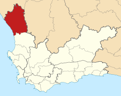
Coordinates (Municipal Offices, Vredendal): 31°39′51″S 18°30′17″E / 31.66417°S 18.50472°ECoordinates: 31°39′51″S 18°30′17″E / 31.66417°S 18.50472°E Country  South Africa
Province Western Cape District West Coast Seat Vredendal Wards 7 Government – Type Municipal council – Mayor Delina Goedeman (DA) Area[1] – Total 5,549 km2 (2,142.5 sq mi) Population (2007)[2] – Total 46,362 – Density 8.4/km2 (21.6/sq mi) – Households 12,881 Population groups[3] – Coloured 87.45% – White 9.03% – Black African 3.44% – Indian or Asian 0.08% Languages[4] – Afrikaans 95.11% – Xhosa 3.32% – English 0.92% Time zone SAST (UTC+2) Municipal code WC011 Website www.matzikamamun.co.za Matzikama Municipality is a local municipality located within the West Coast District Municipality, in the Western Cape province of South Africa. As of 2007, it had a population of 46,362 [2]. Its municipality code is WC011.
Contents
Government
The mayor of the municipality is Patric Bok of the Independent Democrats. It is divided into seven wards with a total of thirteen councillors.
Geography
The municipality has a total area of 5,549 square kilometres (2,142 sq mi).[1]
Adjacent municipalities
- Kamiesberg Local Municipality, Namakwa District Municipality, Northern Cape (north)
- Hantam Local Municipality, Namakwa District Municipality, Northern Cape (east)
- Cederberg Local Municipality (south)
The municipality is bordered by the Atlantic Ocean in the west.
Cities and towns
- Doringbaai
- Ebenhaeser
- Klawer
- Koekenaap
- Lutzville
- Strandfontein
- Vanrhynsdorp
- Vredendal
References
- ^ a b "Matzikama Local Municipality". Municipal Demarcation Board. http://www.demarcation.org.za/PortalPages/info_1.aspx?type=Local&Prov=Western%20Cape&code=WC011. Retrieved 20 June 2010.
- ^ a b "Community Survey, 2007: Basic Results Municipalities" (PDF). Statistics South Africa. http://www.statssa.gov.za/Publications/P03011/P030112007.pdf. Retrieved 20 June 2010.
- ^ "Table: Community Survey 2007 by municipality, population group, gender and age group". Community Survey 2007 interactive data. Statistics South Africa. http://www.statssa.gov.za/timeseriesdata/pxweb2006/Dialog/varval.asp?ma=agegrp_gender__popgrp&ti=Community+Survey+2007+by+municipality%2C+population+group%2C+gender+and+age+group&path=../Database/South%20Africa/Community%20Survey%202007/Persons/Municipality/&lang=1. Retrieved 20 June 2010.
- ^ "Table: Census 2001 by municipalities, language, population group and gender". Census 2001 interactive data. Statistics South Africa. http://www.statssa.gov.za/timeseriesdata/pxweb2006/Dialog/varval.asp?ma=Language%20by%20municpality&ti=Table%3A+Census+2001+by+municipalities%2C+language%2C+population+group+and++gender.&path=../Database/South%20Africa/Population%20Census/Census%202001%20-%20NEW%20Demarcation%20boundaries%20as%20at%209%20December%202005/Municipality%20level%20-%20Persons/&lang=1. Retrieved 20 June 2010.
External links

Matzikama • Cederberg • Bergrivier • Saldanha Bay • Swartland
Cities and towns Abbotsdale • Aurora • Bitterfontein • Chatsworth • Citrusdal • Clanwilliam • Darling • Doringbaai • Dwarskersbos • Ebenhaeser • Eendekuil • Elands Bay • Goedverwacht • Graafwater • Grotto Bay • Hopefield • Jacobsbaai • Jakkalsfontein • Kalbaskraal • Klawer • Koekenaap • Koringberg • Lamberts Bay • Langebaan • Langebaanweg • Lutzville • Malmesbury • Moorreesburg • Paternoster • Piketberg • Porterville • Redelinghuys • Riebeek-Kasteel • Riebeek West • Saldanha • St Helena Bay • Strandfontein • Vanrhynsdorp • Velddrif • Vredenburg • Vredendal • Wupperthal • Yzerfontein
Metropolitan
municipality
District
and local
municipalitiesCategories:- Western Cape geography stubs
- Local Municipalities of West Coast


Wikimedia Foundation. 2010.