- Transportation in Omaha
Transportation in
Omaha, Nebraska includes most major modes, such aspedestrian ,bicycle ,automobile ,bus ,train andairplane . While early transportation consisted of ferries,stagecoach es,steamboat s,street railroad s, andrailroad s, the city's transportation systems have evolved to include theInterstate Highway System , parklike boulevards and a variety of bicycle and pedestrian trails. The historic head of several importantemigrant trail s and theFirst Transcontinental Railroad , its center as a national transportation hub earned Omaha the nickname "Gate City of the West" as early as the 1860s. [Mullens, P.A. (1901) "Biographical Sketches of Edward Creighton and John A. Creighton." Creighton University. p 24.]During a tumultuous pioneer period characterized by its centrality in proximity to the
Western United States , transportation in Omaha demanded the construction of massive warehouses where frontier settlers could stock up and communities west of Omaha got food and supplies to build themselves with. Riverboats and stagecoaches jammed the riverside city with a variety of newcomers, prospectors and shady characters. Early Omaha also landed theUnion Pacific Railroad headquarters, leading to its important place in national railroad lore.After quickly growing into a city, Omaha failed to pave its streets accordingly. A chaotic transportation system was highlighted by several miles of successful
horsecar tracks; however, the city only ever had four miles (6 km) ofcable car service. Several early suburbs were built on reliance of service from these lines, including Dundee, Benson andKountze Place . In the early 1880s an extensiveboulevard system was built to create apark -like atmosphere for drivers throughout the city. TheTrans-Mississippi Exposition in 1889 led to the construction of many new transportation features, particularly the magnificentBurlington Station .In the 1930s the city's transportation system was marred by violent protests. Transit workers wanted to unionize, and with the main company's management against any effort to change Omaha's reputation as a wide open city. After the introduction of
bus es in the early 1950s streetcars were closed down, and in the last years of the decade the city began construction on its components in theInterstate Highway System .Today Omaha's transportation system is growing with the city, and
trail s for bicycles and pedestrians, as well aspublic transportation ,highway s and parkways, and other innovations are being developed. The city has a section of theLincoln Highway listed on theNational Register of Historic Places , and there are more than convert|100|mi|km ofInterstate andfreeway lanes, more than any other area in the state of Nebraska. [O'Connor, M. (2007) [http://www.omaha.com/index.php?u_page=2798&u_sid=2349465 "Smoother commute is down the road",] "Omaha World-Herald." Retrieved 9/28/07.]Pioneer period
[
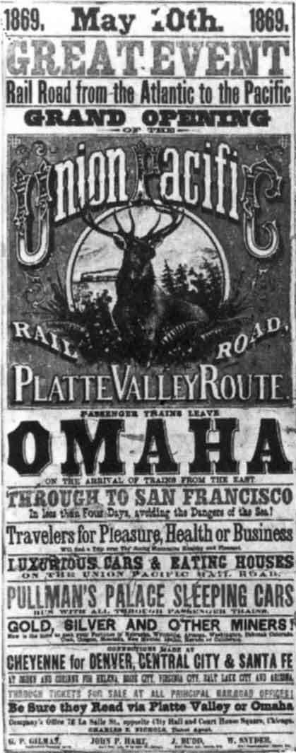 right|thumb|A_period_
Union Pacific poster advertising their route fromOmaha .]Omaha was not projected to become a great city or bigger than its neighbor across the
Missouri River ,Council Bluffs, Iowa . In 1856 a land speculator reported to his East Coast concerns that, :"C. Bluffs is steadily growing down towards the river and someday it will be one great city on both sides the river with Rail Road & foot & Carriage Bridges connecting the two – and this is now the hope and talk of the Bluffers." - J. Barker, 1856. [ [http://www.omahahistory.org/BestofBarkers.pdf "Best of the Barker Letters."] Douglas County Historical Society. Retrieved 9/26/07.]In August 1859
Abraham Lincoln visited land he had invested in Council Bluffs, and while there did not consider it worth the time to cross the river to the village of Omaha. [Larsen and Cottrell. (1997) p 35.]Water traffic
In 1804, fifty years before the city of Omaha was founded, the
Lewis and Clark Expedition first arrived via the Missouri River. The 1806Fort Lisa and 1820Cabanne's Trading Post were importantfur trading outposts located in proximity to the river, along with earlierFontenelle's Post in Bellevue. TheEngineer Cantonment was built by CaptainStephen Watts Kearny 'sYellowstone Expedition in 1819. The Expedition's craft, the "Western Engineer ", was the first steamboat to successfully venture up the Missouri River to the Omaha-Council Bluffs area. [ [http://www.omahariverfront.com/articles2003/20030603_rvrhistory.htm "184 Years of Lost American History is Emerging from Local Missouri River Soil"] . OmahaRiverFront.com. Retrieved 9/25/07.]The Missouri was the reason Omaha was founded, and continued to be important to the city's growth for many years. In 1853
William D. Brown had the first vision for the city, leading him to found theLone Tree Ferry crossing theMissouri River fromCouncil Bluffs, Iowa . Later theCouncil Bluffs and Nebraska Ferry Company hiredAlfred D. Jones toplat Omaha City, which was among the first settlements in theNebraska Territory . Along with the Lone Tree Ferry Landing inDowntown Omaha , other ferries were established in the Omaha area at Florence, Saratoga and Bellevue. Large steamboats would carry provisions up the Missouri from St. Louis, stocking the warehouses inJobbers Canyon and loading the trains of the Union Pacific and at theOmaha Quartermaster Depot , which in turn supplied theU.S. Army 'sDepartment of the Platte .The "Banner State" was the first steamboat to land materials for building the city in early 1854, before the city was formally founded. [ [http://www.steamboats.org/history-education/capt-william-rodney-massie.html "History of Captain William Massey"] Steamboats.org. Retrieved 9/25/07.] Until 1879 Captain
Joseph La Barge was the principal figure among the Missouri steamboat captains in the early years of the city. According toJ. Sterling Morton , the golden era for steamboating on the Missouri was from 1855 to 1860, just before the advent of the railroads. [Morton, J. and Watkins, A. (1918) [http://www.rootsweb.com/~neresour/OLLibrary/MWHNE/mwhne086.htm "Old Trading Post - Bellevue in 1856,"] "History of Nebraska from the Earliest Explorations of the Trans-Mississippi Region". Lincoln, NE: Western Publishing and Engraving Company. p. 86. Retrieved 7/15/07.] In 1857, 174 steamboats carrying 13,000 tons of freight tied up at Omaha wharves. When Omaha became the outfitting center forColorado gold seekers headed forPikes Peak in 1859, 268 steamboats arrived at Omaha between March and November. [ [http://www.omahahistory.org/Education_Timeline3.htm "Omaha Timeline"] Omaha Public Library. Retrieved 9/25/07.]With railroads becoming the dominant form of long-range shipping and passenger travel in the early 1870s, riverboats like those in Omaha became obsolete. However, as late at 1949 the steamship "Avalon" was letting passengers in Omaha, before becoming one of the famous St. Louis steamboats in the 1960s. [ [http://www.belleoflouisville.org/history.php "History - Belle of Louisville."] Retrieved 9/25/07.] [ [http://www.historicomaha.com/chap17.htm "Chapter XVII: Romance of Omaha."] "Omaha World-Herald. Retrieved 9/25/07.]
Railroads
In 1863 ground was broke near
Miller's Landing on the Missouri River for theFirst Transcontinental Railroad . Along with local financierEdward Creighton , [Mullens, P.A. (1901) "Biographical Sketches of Edward Creighton and John A. Creighton." Creighton University. p 24.]George Francis Train was the promoter who was mostly responsible for the city landing the railroad. He was made rich from its convenient placement near land that he owned (near Deer Park. [Bristow, D.L. (2002) "A dirty, wicked town: Tales of 19th century Omaha." Caxton Press. p 66.] TheUnion Pacific Railroad has been headquartered in Omaha since its inception in 1867. In 1872 Union Pacific opened the first bridge across the Missouri to Omaha. [Larsen, L.H. and Cottrell, B.J. (1997) "The Gate City: A history of Omaha." University of Nebraska Press. p 65.]Trails
In the 1860s and 70s the city became a major
outfitting center for the major trails that went across Nebraska, including the Oregon, California and MormonTrail s.Jobbers Canyon was built inDowntown Omaha for the purpose of outfitting these migrants. Stagecoach lines had arrived by 1858, including theLocal Stage Coach Company in 1857, and theWestern Stage Company which began its easterly and westerly routes in Omaha. ThePony Express and Wells Fargo lines maintained offices in the city.treets
Omaha had terrible streets through the late 1880s, which caused many residents to believe the city was not progressing appropriately. This lack of responsiveness by the city government was caused by property owners throughout the city who did not want to pay for improvements. On rainy days
stagecoach es would sink up to theirhubcaps , and residents woreknee -high boots to wade through the mud, and at times rivers ran through the streets. [Larsen and Cottrell. (1997) p 101.]Public transportation
In 1867
Ezra Millard ,Andrew J. Hanscom , andAugustus Kountze formed theOmaha Horse Railway Company to providehorsecar service in the city. By the late 1870s the line had five miles (8 km) of track, 10 cars, 70 horses, 20 employees and 495,000 passengers annually. [Larsen and Cottrell. (1997) p 106.] TheOmaha Cable Tramway Company was the city's only cable car, and started in 1884 and ended in 1895 after consolidating with the Horse Railway as theOmaha Street Railway Company . In 1896 the new company disbanded as competitors moved in. [ [http://www.omahahistory.org/Education_Timeline6.htm "Omaha Timeline."] Douglas County Historical Society. Retrieved 9/23/07.] Anelectric car was built byEurastus Benson between Omaha and Benson specifically to promote that suburbs development during this time.1880s - 1950
treets
In 1880 only a quarter mile of Omaha's estimated convert|118|mi|km of streets were paved. In 1883 Andrew Rosewater, brother of newspaper owner
Edward Rosewater , became city engineer and began an ambitious project to modernize city streets. By 1886 the city had convert|44|mi|km of paved streets, includingasphaltum , Coloradosandstone , Sioux Fallsgranite andwood en blocks. [Larsen and Cottrell. (1997) p 106.]In 1889
Horace W.S. Cleveland proposed that the city of Omaha develop a series of "broad ornamental avenues, known as boulevards or parkways" designed "with a tasteful arrangement of trees and shrubbery at the sides and in the center", similar to the comprehensive plans of European cities in the mid-1800s. His plan was accepted by the city's Parks Commission, resulting in the construction ofOmaha's Prettiest Mile Boulevard in 1892, and dozens of other boulevards in the through to the present. [ [http://www.ci.omaha.ne.us/parks/Suburban%20Master%20Plan/2006%20Suburban%20Park%20Boulevards%20Design%20Standards.pdf "Omaha's Suburban Park Plan"] . City of Omaha. p 63. Retrieved 9/15/07.] Today, Fontenelle and Lincoln boulevards are among the many remnants of the early plan;Sorenson Parkway is a modern version of the historical plan. Saddle Creek Boulevard, currently known as Saddle Creek Road, which was originally the westernmost boulevard in the system. [ [http://www.nr.nps.gov/iwisapi/explorer.dll?IWS_SCHEMA=Cover&IWS_LOGIN=1&IWS_REPORT=100000008 "Bridges in Nebraska Multiple Property Submission."] National Park Service. Retrieved 10/16/07.]Bridges
While the
Union Pacific Missouri River Bridge was the first railroad bridge across the river, the convert|1400|ft|m|sing=onDouglas Street Bridge opened in 1888. The Mormon Bridge was first attempted to be built across the river in 1932, and failed. It was successfully constructed in 1952. TheSouth Omaha Bridge opened in 1936. TheKnights of Ak-Sar-Ben operated the Douglas Street Bridge as a tollbridge from 1938 to 1947, and in 1986 the oldgirder bridge was be the new I-480 in 1966. [ [http://www.omahapubliclibrary.org/earlyomaha/bridges/douglasbridge.html Douglas Street Bridge.] Omaha Public Library. Retrieved 9/24/07.] TheSaddle Creek Underpass , over which is the Dodge Street Overpass, was completed in 1934 by theWorks Progress Administration . Over convert|1175|cuyd|m3 of dirt were excavated to lower Saddle Creek Road sufficiently to pass under the overpass, which is still in use today. Listed on theNational Register of Historic Places in 1992, [ [http://www.nebraskahistory.org/histpres/nebraska/douglas2.htm "More National Register Sites in Douglas County,"] Nebraska State Historical Society. Retrieved 10/16/07.] it is part of theBridges in Nebraska Multiple Property Submission as well. [ [http://www.nr.nps.gov/iwisapi/explorer.dll?IWS_SCHEMA=Cover&IWS_LOGIN=1&IWS_REPORT=100000008 "Bridges in Nebraska Multiple Property Submission."] National Park Service. Retrieved 10/16/07.]Highways
In 1889 Otto Baysdorfer built Omaha's first auto, an
electric car . The "Ottomobile" was the first of nearly a dozen car manufacturers eventually started in Omaha. The Ottomobile weighed 265 pounds, had two cylinders, and could achieve a speed of 15 miles per hour. [ [http://www.omahahistory.org/Education_Timeline7.htm "Omaha Timeline,"] Douglas County Historical Society. Retrieved 9/23/07.] An "Auto Row" developed along Farnam Street and featured dealers, garages, and parts stores.The original Lincoln Highway in Omaha was designated through Omaha in 1913. Crossing the
Missouri River into Omaha on the old Douglas Street Bridge, it traveled west on Dodge Street, then meandered across the state followingsection lines. Some of these sections were built exclusively to accommodate the highway. [(2002) [http://www.iup.edu/geography/faculty/lhpdf/resourceguide/CH12%20Lincoln%20Highway%20in%20Nebraska.pdf "Chapter 12: Lincoln Highway in Nebraska,"] "The Lincoln Highway Resource Guide." p 157. Retrieved 9/21/07.] Important buildings on the Lincoln Highway in Omaha included theNash Buildings at 902-912 Farnum and 901-911 Douglas streets, as well as the Blackstone Hotel at Farnum Street and 36th Street. [(2002) [http://www.iup.edu/geography/faculty/lhpdf/resourceguide/CH12.1%20Lincoln%20Highway%20in%20Nebraska%20Resources.pdf "Chapter 12.1: Nebraska Lincoln Highway Historic and Cultural Resources,"] "The Lincoln Highway Resource Guide." p 161. Retrieved 9/21/07.] Additionally, theRose Blumkin Performance Arts Center at 20th and Farnum Street and theFarnum Street Automobile Row , from 30th to 40th Streets were both important landmarks. [(2002) [http://www.iup.edu/geography/faculty/lhpdf/resourceguide/CH12.1%20Lincoln%20Highway%20in%20Nebraska%20Resources.pdf "Chapter 12.1: Nebraska Lincoln Highway Historic and Cultural Resources,"] "The Lincoln Highway Resource Guide." p 163. Retrieved 9/21/07.]In 1930 49,128 autos were registered in Omaha; ten years later 65,489 were registered to drive on local streets.
After
truck s became popular in the 1910s, the Omaha Stockyards grew exponentially.Cattle , hogs andsheep were shipped cheaper by truck than by trains. In 1919 27% of livestock at the Stockyards was shipped by truck; by 1940's it rose to over 75%. In 1955 the Stockyards became the biggest livestock distribution center in the United States, and almost all of the cattle was shipped by truck. [Graham, J. (1999) [http://www.texnews.com/1998/1999/ads/farmranch/omaha0328.html "Omaha stockyards packing it in."] "Chicago Tribune." 3/28/99. Retrieved 6/23/07.]Airport
The aforementioned Baysdorfer provided Omaha with another invention by successfully flying an
airship in the city in 1889. In 1929 a bond was passed that would construct theOmaha Municipal Airport in East Omaha. This was thought to embody the city's hope for the future; however, air travel did not become popular in Omaha until the 1960s. [Larsen and Cottrell. (1997) p 152.] The land was swampy and had to be filled in with silt taken from the bottom of Carter Lake. Northwest Airlines started service between Minneapolis and Omaha in 1930.In the late 1940s Eppley Airfield was completed. In 1959 the airport was named for
Eugene C. Eppley , the Omaha Eppley Hotel magnate. Eppley's estate donated $1 million to be used to convert the Omaha Municipal Airport into a jet port. [(1959) "Eppley Grant of $1 Million Gives Omaha Jet Field". "Lincoln Evening Journal." December 31, 1959.]Public transportation
The
Omaha and Council Bluffs Railway and Bridge Company was founded in 1886 in order to span theMissouri River . [Orr, R. (1996) "O&CB: Streetcars of Omaha and Council Bluffs." p 154.] In the late 1880s the city had five franchise companies providing transit services within city limits. They included the Omaha and Southwestern Street Railway Company, which provided services toKountze Place , Dundee,Bemis Park and theGold Coast neighborhoods. Short lines ran with limited purposes: one went only to a baseball field at the end of its line, while another ran to and from a park. [Larsen and Cottrell. (1997) p 107.]By 1901 local businessman
Gurdon W. Wattles consolidated several of the older horsecar and cable car companies to create theOmaha and Council Bluffs Streetcar Company , which later became theOmaha Traction Company . After receiving a 30-year franchise from the city of Omaha, the company established amass transit system that covered the entire city, includingcommuter train s andinterurban s. [Larsen, L.H. and Cottrell, B.J. (1997) "The Gate City: A history of Omaha." University of Nebraska Press. p 107.]Traction Company strike
Wattles was vehemently opposed to
unionization , and in 1909 foughtstrike s in favor of unionization with hiredpolicemen and rampant violence. By 1934 theAmalgamated Association of Street and Electric Railway Employees was organized in Omaha.However, by April 1935 the fragile truce between pro-
open shop management and pro-union forces broke. A long, violent strike ensued.Strikebreaker s were hired, and within four days the company rolled out heavily fortified streetcars, complete with windows covered by heavy wire and armed guards on board. While few cars attracted passengers, the cars encountered little resistance. The company resisted calls forarbitration from theOmaha City Council , and continued employing strikebreakers. In early May violence broke out, with rifle attacks, violent beatings and bombings across the city. In June riots broke out throughout the city with mobs burning streetcars, looting and two deaths. The city government lost control of the violence and called in the National Guard, which sent 1,800 troops while GovernorRobert Cochran declaredmartial law and ordered the streetcars to stop running. After the governor intervened and Wattles allowed arbitration, a number of agreements were made. However, no changes occurred, and strikebreakers stayed on the job. The violence ended, court cases ensued, and the situation slowly faded away. The Omaha Traction Company never unionized. [Larsen and Cottrell (1997) p 202-204.]Omaha Belt Line
The Omaha Belt Line was formed in 1883 by the
Union Pacific ; some shady dealings byJay Gould brought the Belt Line into the control of theMissouri Pacific Railroad by 1885, when it was constructed with Union Pacific materials under the control of the MoPac. Stations along with Line included theFlorence Depot ,Webster Street Station and theRalston Station . Operated by that company until the early 1960s, today the Line is largely abandoned, with a section redeveloped into the recreationalMoPac Trail .1950-present
treets
Starting in 1950 the city has continuously developed and redeveloped its major streets, particularly relying on them for east-west traffic. Major east-west thoroughfares in Omaha include Fort, Maple, Blondo, Dodge, Pacific,
Center Street , L, Q and Harrison streets. Major north-south thoroughfares in Omaha include 24th, 30th, Saddle Creek, 72nd, 84th, 90th, and 120th streets.Highways
The first long segment of
Interstate 80 in Nebraska to be opened was a fifty mile section between Dodge Street in Omaha and the West Lincoln interchange in 1961. [(1961) " [http://www.nebraskatransportation.org/history/docs/1961-I-80-omaha-lincoln.pdf Nebraska Interstate 80 Lincoln - Omaha] ." Nebraska Department of Roads. Retrieved 9/23/07]Construction of the a
freeway inNorth Omaha in the 1970s faced many hurdles. Built immediately after the construction of I-480, this convert|4|mi|km|sing=on section was originally supposed to be designated as Interstate 580. However, the city refused to invest the additional money the federal government required in order to gain the designation. Coupled with social unrest in the 1970s, the highway is blamed for causing a 30 percent housing loss and major increase in crime. [(2001) [http://pio.neded.org/press/2001/01rel21.htm State's top community development projects honored] . Nebraska Department of Economic Development. Retrieved 4/7/07.] The freeway became the route ofU.S. Highway 75 and is known locally as the North Freeway.Today Omaha is well connected to the
Interstate Highway System . The city has elevenhighway exit s along Interstate 80. From that Interstate drivers can connect toNebraska Highway 50 , US 275/NE 92, I-680 and I-480/US 75. Continuing north, I-680 connects withI-29 nearCrescent, Iowa and reconnects with I-80 nearNeola, Iowa ; I-480 cuts throughDowntown Omaha to connect with I-29 inCouncil Bluffs, Iowa . The North Freeway also veers from I-480, and in 2005, theNebraska Department of Roads began a project to bring the I-480/US 75 interchange up to Interstate standards. Construction is expected to be complete in 2009, and it is unknown if the North Freeway will receive an Interstate designation upon completion of the project.There are a number of important arterial roads throughout Omaha.
U.S. Route 75 comes south through Omaha from Fort Calhoun along North 30 Street, North Freeway, I-480 and Kennedy Freeway, exiting through Bellevue.U.S. Route 6 crosses into the city from Council Bluffs on I-480, also called theGerald R. Ford Freeway in honor of the Omaha native son. It then follows Dodge Street, until it intersects South 204th Street, when it runs south towards Gretna.Nebraska Highway 64 assumes the route of the former Military Road northwest out of Omaha, following Maple Road and West Maple Road to converge with US 275 at Waterloo. US 275 becomesNebraska Highway 92 after crossing theSouth Omaha Veterans Memorial Bridge , following Missouri Avenue, which then becomes "L" Street. At South 132th Street, at which point it veers northeast to follow the oldMormon Trail along Industrial Road when it joins West Center Road, crossing thePlatte River and continuing westward.In 2005 a portion of the Lincoln Highway in Omaha was listed on the
National Register of Historic Places .Traffic monitoring
Beginning in fall 2007 there will be more than 30
traffic camera s operating on Omaha area freeways, including one at I-80 near Gretna and the other on West Dodge near 120th Street. Operated by theNebraska Department of Roads , the sensors and cameras are not used to catchspeeder s or for othertraffic enforcement . The state also operates an extensive traffic operations center that utilizes the cameras to monitor Omahatraffic pattern s. Similar to traffic monitoring centers in Lincoln and North Platte, the one in Omaha is the biggest and has the greatest capability to provide traffic information. [O'Connor, M. (2007) [http://www.omaha.com/index.php?u_page=2798&u_sid=2349465 "Smoother commute is down the road",] "Omaha World-Herald." Retrieved 9/28/07.]Public transportation
The Omaha Traction Company, which operated as the Street Railway Company, changed its name to the Omaha Transit Company when streetcar service ended in the city in 1952. After
World War II Omahans preferred their automobiles and new highways. When theUrban Mass Transit Act of 1964 was passed, Omaha's private transit companies were not able to apply for federal subsidies available topublic transit operators. The Omaha Transit Company ceased operations on June 30, 1972, when the City of Omaha assumed authority forpublic transportation in the city. City Transit Lines, another private company in Omaha, went out of business on that day as well. [ [http://www.metroareatransit.com/html/history.html "History of MAT"] , Metro Area Transit. Retrieved 9/24/07.] The Metro Area Transit Authority was created by theNebraska Legislature , consisting of a five member board appointed by the mayor and confirmed by Omaha's City Council and theDouglas County Commissioners . It acquired the assets of the Omaha Transit Company and selected assets of the City Transit Lines of Council Bluffs, along with more than $3,000,000 in federal funding. The Authority operates today asMetro Area Transit , or MAT. [ [http://www.metroareatransit.com/html/savedmetro.html "Saved Metro Area Transit."] MAT. Retrieved 9/25/07.]Today the Authority supervises the level of service, miles and hours of operation within Omaha, and maintains individual service
contract s with local authorities outside Omaha. Currently, MAT has three contracts, including the cities of Council Bluffs, Bellevue and the Tri-Communities of Ralston, LaVista and Papillion. [ [http://www.metroareatransit.com/html/history.html "History,"] Metro Area Transit. Retrieved 9/24/07.]MAT recently completed three new
transit center s, which function much like airport hubs. Located atBenson Park ,Westroads Mall and inSouth Omaha , they are designed to bolster the city's public busing needs. [ [http://www.livelyomaha.org/Civic_Omaha/Transit_Centers/Transit_Centers.html "Trio of Omaha Transit Centers Takes Shape"] . Omaha By Design. Retrieved 9/25/07.] These join existing centers in Midtown andNorth Omaha .Light rail
In recent years the city of Omaha has grown exponentially, and with a renewed focus on
public transit , there have been plans for newstreetcar s andlight rail in the city, including a movement initiated by former mayorHal Daub , which in a 2003 City Council action, failed to reach approval by only one vote. [Miller, E.C. and Kopiasz, G. (2007) "Light Rail and Omaha: It Takes a Proactive Community to Build Light Rail: the Case for Omaha," "New Colonist." May 2007.] The currently proposed streetcars would cost $55 million and run in a convert|3.5|mi|km|sing=on loop throughDowntown Omaha andNoDo . It would cost about $2 million per year to operate and would serve almost 7,000 passengers in its first year. One route would run the cars fromCreighton University near 20th and Webster streets, proceeding east to 10th Street, passing by theQwest Center and moving south to Jackson Street in theOld Market . After that it would then move west to 16th Street and then north to Farnam before returning to 10th Street. [Beals, J. [http://omahacityweekly.com/article.php?id=2548 "Streetcar Pool: Omaha moves closer to building a light-rail system"] . "Omaha City Weekly." Retrieved 9/25/07.]Air
Today Eppley Airfield sits on convert|2650|acre|km2 and handles approximately 400 flights a week. There are two
concourse s that hold 21gate s. The airport handled more than 4.2 million passengers in 2006, and as of July 2007,Southwest Airlines is the largest carrier handling approximately 23 percent of passengers. Currently all regularly-scheduled flights from Eppley Airfield terminate within the United States. [ [http://www.eppleyairfield.com/sf/default.htm "Statistics and facts"] , Eppley Airfield. Retrieved 3/29/08.]Airline s serving Omaha include American, Delta, Frontier,Midwest Airlines , Northwest, Continental, ExpressJet,Mesa Airlines , Southwest, United andUS Airways .Trails
Omaha was completely devoid of trails leading up to early 1989. That year the city began developing trails, and since then the city of Omaha has developed approximately convert|67|mi|km of paved recreational trails, [ [http://www.ci.omaha.ne.us/parks/ Parks and Recreation.] City of Omaha. Retrieved 9/20/07.] and another convert|35|mi|km of trails are scheduled for completion within the next eight years. [Greer, D.L. (2001) " [http://www.unomaha.edu/recadmin/trails/nebtrails.pdf Nebraska Rural Trails: Three Studies of Rail Impact.] " University of Nebraska at Omaha. p 9.]
Paved and unpaved
trail s and paths are used forrecreation al andcommuter purposes throughout the city. Popular amongbicyclist s, runners,hiker s and recreationalwalker s, these trails are included in comprehensive plans for the city of Omaha, theOmaha metro area , Douglas County, and long-distance coordinated plans between the municipalities of southeastNebraska . [ [http://www.omahatrails.com/ "Omaha Trails"] . Retrieved 9/18/07.]The
Missouri River Pedestrian Bridge will connect Miller's Landing to Council Bluffs in 2009. A riverfront trail will run the length of the river from the South Omaha Bridge toN.P. Dodge Park .Water traffic
An anomaly in the city's transportation is the
River City Star , a passenger excursionpaddleboat that sails between Omaha and Council Bluffs. The boat is docked atMiller's Landing near theQwest Center , near mile marker 617 on the Missouri River.Marina s for public usage are operated by theOmaha Parks and Recreation Department .Dodge Park , located inNorth Omaha , has 326slip s, while the newRiverfront Marina in Downtown Omaha has 31.Levi Carter Park , which has a long history as a water haven, offers non-restricted boating forjet ski s, recreationalboat ing andwater ski ing. No wake boating allowed available atLake Cunningham ,Standing Bear Lake orZorinsky Lake ; however, these lakes offer opportunities for sailing, fishing and pleasure boating. Cunningham Lake offers a small marina where rental boats are available. [ [http://www.ci.omaha.ne.us/parks/Marina/marinamaster.htm Marinas and boating] . City of Omaha. Retrieved 9/26/07.]The
Port of Omaha was located downtown whereMiller's Landing is now. In addition to handling outboundbarge shipments ofgrain , it also handled inbound shipments ofsteel andasphalt . [Larsen, L.H., Cottrell, B.J. and Dalstrom, H.A. (1997) "Upstream Metropolis: An Urban Biography of Omaha and Council Bluffs." University of Nebraska Press. p 411.]The Omaha District of the
U.S. Army Corps of Engineers operates from the city.ee also
*
Interstate 80 in Nebraska Image gallery
References
Bibliography
* Raschke, W.A. (1998) "Omaha Belt Line Railway" "The Eagle, 23" a journal of the Missouri Pacific Historical Society. p 20.
* Bartels, M.M. (1997) "Missouri Pacific River & Prairie Rails: The MoPac in Nebraska." South Platte Press.
* Greer, D.L. (2000) " [http://www.unomaha.edu/recadmin/trails/omahatrails.pdf Omaha Recreational Trails: Their Effect on Property Values and Public Safety] ". University of Nebraska at Omaha. Retrieved 9/20/07.
* RDG Martin Shukert and Ciaccio Dennell Group. (1994) " [http://www.nlc.state.ne.us/docs/nlcwesterntrails/NetworkofDiscovery/index.html A Network of Discovery: A Comprehensive Trails Plan for the State of Nebraska.] " Nebraska Energy Office and the Nebraska Department of Economic Development.External links
* [http://www.cbpl.lib.ia.us/Simons/omahasteam.htm 1856 drawing] of the steamer "Omaha" landing Mormon settlers at Florence
* [http://www.MetroRideshare.org/ Metropolitan Area Planning Agency (MAPA)'s Official Carpool and Rideshare Website]
Wikimedia Foundation. 2010.