- Loring Air Force Base
Infobox Airport
name = Loring Air Force Base Loring International Airport
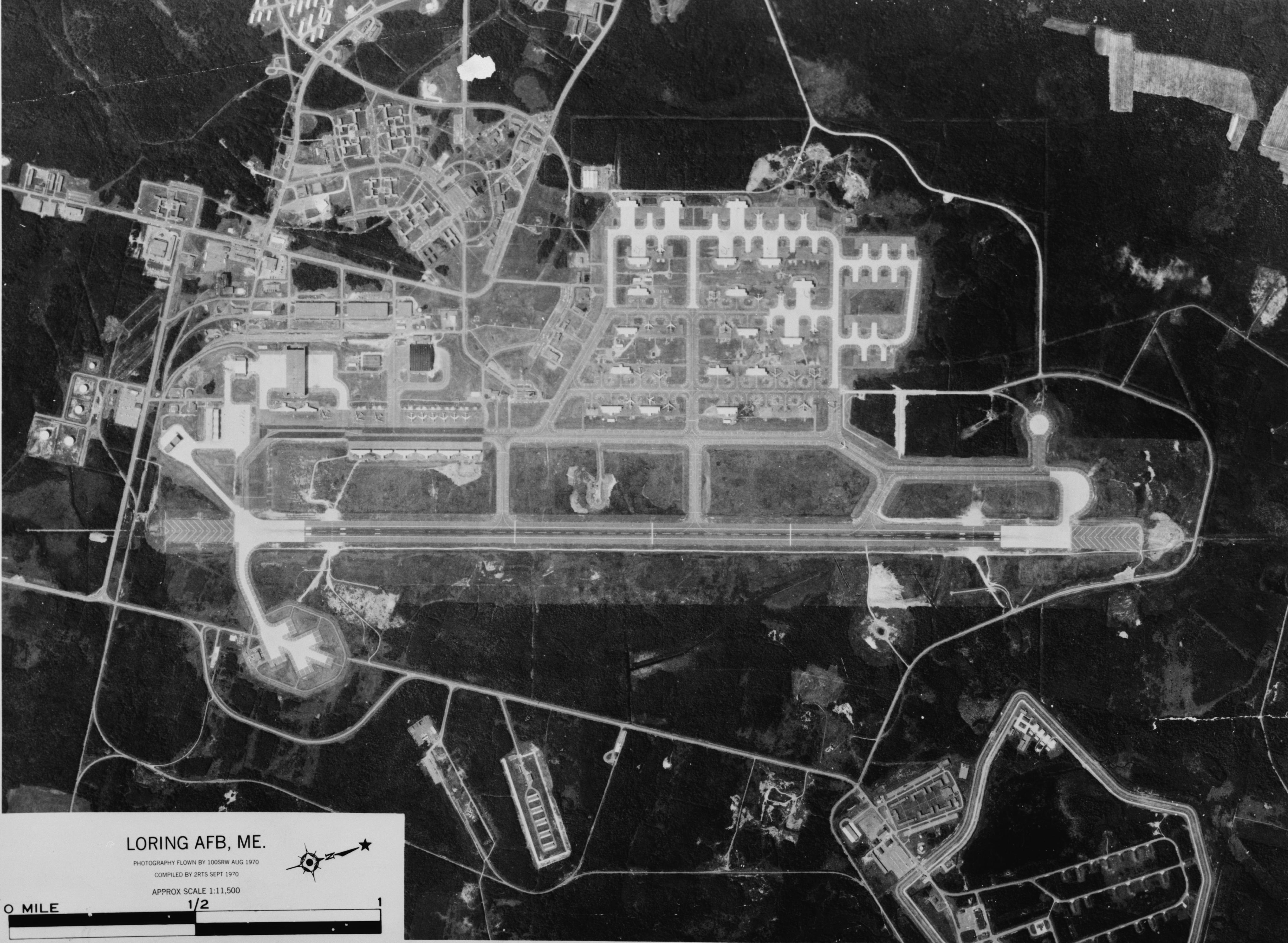
caption = 1970 aerial photograph of Loring Air Force Base
IATA =
ICAO = ME16
FAA =
type = Military/Public
owner = Loring Development Authority
operator =
city-served =
location =Limestone, Maine
built =
used = 1953 - 1994
commander =
occupants =42nd Bomb Wing
elevation-f = 745
elevation-m = 227
coordinates = coord|46|57|00|N|67|53|00|W|type:airport
website =
r1-number = 1/19
r1-length-f = 12,101
r1-length-m = 3,688
r1-surface = Asphalt/Concrete
r2-number = 1/19 (Alternate)
r2-length-f = 13,209
r2-length-m = 4,026
r2-surface = Asphalt
footnotes = Source: http://www.airnav.com/airport/ME16Loring Air Force Base is a former
United States Air Force base that was under the operational control of theStrategic Air Command (SAC) for most of its existence. In 1992, it was transferred to the newly-establishedAir Combat Command , and it was finally closed as an active Air Force installation in 1994. Loring is located in Limestone,Aroostook County, Maine . It is treated for statistical purposes by theUnited States Census Bureau as acensus-designated place . At the 2000 census, the base had a total population of 225. It was named for MajorCharles J. Loring, Jr. ,USAF , aMedal of Honor recipient during theKorean War .History
Beginnings
Loring AFB was carved out of the woods of Maine in 1953. It was named after
Charles J. Loring, Jr. , who was killed in theKorean War . Along with the nearbyPresque Isle Air Force Base , some of its roads were named after states in the Union. It was the closest Air Force base on the east coast to Europe. It was originally built with a capacity of 100B-36 Peacemaker bombers.42nd Bomb Wing
The host wing for Loring AFB throughout its existence was the
42nd Bomb Wing . The wing originally flew theB-36 Peacemaker , upgrading later to theB-52 Stratofortress . The wing also flew theKC-135 Stratotanker .Weapons Storage Area
The Nuclear Weapons Storage Area at Loring once operated as a separate, top secret facility. Originally called Caribou Air Force Station, the remote area to the northeast of Loring’s property was the first U.S. site specifically constructed for the storage, assembly, and testing of atomic weapons.
Historic American Engineering Record . "Loring Air Force Base, Weapons Storage Area, Northeastern corner of base at northern end of Maine Road, Limestone vicinity, Aroostook County, ME". On file withThe Library of Congress .]A parallel ribbon of four fences, one of which was electrified, surrounded the heart of the storage area. This area was nicknamed the “Q” area, which denoted the Department of Energy’s "Q" level security clearance required to enter.
In June 1962, the Atomic Energy Commission released its custody and ownership of the weapons to the Air Force. The personnel and property of Caribou Air Force Station were absorbed into that of the adjacent Loring Air Force Base.
On the nights of October 28th and 29th in 1975, there were two sightings of unidentified helicopters breaching the base perimeter in the area of the WSA just north of Loring AFB. One of the helicopters reported landed within the weapons storage area. [http://www.dod.mil/pubs/foi/ufo/assort1.pdf]
Closure
Loring AFB was first targeted for closure in 1976. The Air Force's primary rationale at that time was the poor condition of Loring AFB's facilities. In 1976, it was estimated that Loring AFB needed up to $300 million in facilities improvements. Between 1976 and 1979, considerable debate took place over the strategic importance of Loring AFB, resulting in a reversal of the Air Force decision to close the base. When the decision to keep Loring AFB open was made in 1979, Congress committed itself to upgrading the base facilities. Since 1981, nearly $300 million in military construction and operations and maintenance funds were spent to upgrade the facilities.
In 1991, the Secretary of Defense, upon the recommendation of the Secretary of the Air Force, identified six Strategic Air Command bases for closure. Loring Air Force Base was one of the six bases on the closure list.
The official base closure date was September 30, 1994.
Geography
Loring AFB is located at coor dms|46|56|13|N|67|54|0|W|city (46.936948, -67.900075).GR|1
According to the
United States Census Bureau , the base CDP has a total area of 8.2 mi² (21.3 km²). 8.2 mi² (21.3 km²) of it is land and 0.04 mi² (0.1 km²) of it (0.36%) is water.Things Unique to Loring [ [http://www.strategic-air-command.com/bases/Loring_AFB.htm Loring AFB - 42nd Bomb Wing - B-36, B-52 ] ]
*Contained convert|14300|acre|km2, making it the biggest SAC base in the country
*2 runways, only two other SAC bases had two runways
*The largest capacity for weapon storage and for fuel storage in all of SAC (Its overall capacity ranked second among all 21 SAC bases)
**Weapons storage capacity was 10,247,882 NEW (Net Explosive Weight) (the highest in all of SAC)
**1st in all of SAC in fuel storage capacity (9,193,374 gallons)
*Ramp space exceeds 1.1 million square yards. (2nd among all SAC bases in total ramp space, 1st in excess ramp space)
*One of two fully capable conventional weapons storage facilities in CONUS maintained by SAC.
*A small downhill ski area provided recreation for personnel and their dependents, operating on the base from the early 1960s until the base's closure in 1994. [ [http://www.nelsap.org/me/loring.html Loring AFB ] ]Units Based at Loring
*
42nd Bomb Wing (1953-1994)
**42nd Air Refueling Squadron (1955-1994)
**69th Bombardment Squadron (1952-1961)
**70th Bombardment Squadron (1953-1966)
**75th Bombardment Squadron (1953-1956)
**407th Air Refueling Squadron (1962-1991)
**42nd Security Police Squadron
**42nd Civil Engineering Squadron
**42nd Maintenance Squadron
**42nd Munitions Maintenance Squadron
**42nd Airborne Missile Maintenance Squadron (1964-1974)
*1st Fighter Wing
**27th Fighter Squadron
*102d Fighter Wing
**101st Fighter Squadron (1992-1993)
*102d Fighter Interceptor Wing
**101st Fighter Interceptor Squadron (1986-1992)Planes Based at Loring [ [http://www.au.af.mil/42abw/42abw_history_aircraft_assigned.asp 42nd Air Base Wing: History: Aircraft Assigned ] ]
*
KC-135R Stratotanker (Jan 1957-7 Jul 1959)
*B-52G Stratofortress (21 May 1959-16 Nov 1993)
*B-52D Stratofortress (25 May 1989-2 Mar 1994)
*KC-135A Stratotanker (16 Oct 1957-7 May 1990)
*B-52C Stratofortress (16 Jun 1956-Jan 1957)
*KC-97G Stratotanker (15 Feb 1955-16 Dec 1957)
*B-36 Peacemaker (Apr 1 1953-6 Sep 1956)Post Base Usage
The convert|9472|acre|km2|sing=on base property is now administered by the Loring Development Authority of Maine. The base is now called the Loring Commerce Center and is marketed as an "aviation and industrial complex and business park".
Military Users to the old base include:
* DFAS Limestone, a major component of theDefense Finance and Accounting Service office (BRAC 2005 consolidated 26 offices into 5 and this was one of the consolidation points
* Maine Military Authority, refurbishesHigh Mobility Multipurpose Wheeled Vehicle s (HMMWV’s) for the US Army and Marine CorpsCivilian users of the facility include:
* Loring Job Corps Center
* U.S. Fish & Wildlife National Wildlife Refuge (administering convert|4700|acre|km2 of the base property)* various call centers, food processing and forestry operations, light manufacturing, and aviation services
The airfield at Loring Commerce Center was used by the popular jam-band
Phish , to hold its massive festival concerts, "The Great Went " in 1997, theLemonwheel in 1998 and "It" in 2003. Estimated attendance was 65,000 and 60,000 concert-goers respectively and Phish was the only band at both events. Fans camped on-site in tents, creating a community of fans that became the second largest city in Maine during both events. Phish is currently planning another festival at the base, name yet to be determined, to close out their upcoming Summer 2009 reunion tour.Demographics
As of the
census GR|2 of 2000, there were 225 people, 82 households, and 57 families residing on the base. Thepopulation density was 27.4/mi² (10.6/km²). There were 355 housing units at an average density of 43.2/mi² (16.7/km²). The racial makeup of the base was 81.33% White, 10.22% African American, 2.22% Asian, 5.33% from other races, and 0.89% from two or more races. Hispanic or Latino of any race were 13.78% of the population.There were 82 households out of which 53.7% had children under the age of 18 living with them, 54.9% were married couples living together, 11.0% had a female householder with no husband present, and 29.3% were non-families. 28.0% of all households were made up of individuals and 1.2% had someone living alone who was 65 years of age or older. The average household size was 2.74 and the average family size was 3.38.
On the base the population was spread out with 37.3% under the age of 18, 5.3% from 18 to 24, 43.6% from 25 to 44, 10.7% from 45 to 64, and 3.1% who were 65 years of age or older. The median age was 29 years. For every 100 females there were 90.7 males. For every 100 females age 18 and over, there were 93.2 males.
The median income for a household on the base was $36,667, and the median income for a family was $39,844. Males had a median income of $33,125 versus $25,724 for females. The
per capita income on the base was $19,888. None of the families and 5.0% of the population were below thepoverty line , including none of those under the age of 18 or ages 65 and older.Gallery
ee also
*
The Cold War
*Eastern Air Defense Force (Air Defense Command)References
External links
* [http://www.globalsecurity.org/wmd/facility/loring.htm Base description on Global Security website]
* [http://www.loring.org/ Loring Commerce Centre]
* [http://www.loringairforcebase.com/ LoringAirForceBase.com]
* [http://www.loringramprats.com/ Loring Ramp Rats - 42nd Security Police Squadron]
* [http://www.all-hazards.com/loring/photos.html Photos of Loring]
* [http://www.au.af.mil/42abw/42cs/index.asp 42nd Air Base Wing Official Page]
* [http://www.loringafbmuseum.org/component/option,com_frontpage/Itemid,1/ Loring AFB Heritage Museum]
Wikimedia Foundation. 2010.