- Deepwater Shoals Light
-
Deepwater Shoals Light 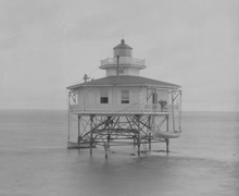
Undated photograph of Deepwater Shoals Light (USCG) Location Off Fort Eustis in the James River, northwest of Newport News, Virginia Coordinates 37°8′11.456″N 76°38′12.476″W / 37.13651556°N 76.63679889°WCoordinates: 37°8′11.456″N 76°38′12.476″W / 37.13651556°N 76.63679889°W Year first lit 1855 Deactivated 1936 Foundation wood-pile Construction cast-iron/wood Tower shape hexagonal house Height 27 ft Original lens sixth-order Fresnel lens Characteristic fixed white The Deepwater Shoals Light was a lighthouse located in the James River upstream from Newport News, Virginia.
History
This light was erected in 1855 to mark the western edge of the channel. Ice damaged the light in the following year, and again in 1867; in the latter case the light had to be rebuilt completely, at which time the light was upgraded to a sixth-order Fresnel from the previous masthead light. During the Civil War the light was extinguished by confederate forces; relit in 1862, the Lighthouse Board reconsidered and removed the lighting apparatus to Fort Monroe for safekeeping.
Decommissioning came in 1936, and the house was torn down in 1966. A steel tower light has been erected on the old iron foundation.
References
- "Historic Light Station Information and Photography: Virginia". United States Coast Guard Historian's Office. http://www.uscg.mil/history/weblighthouses/LHVA.asp.
- Deepwater Shoals Light, from the Chesapeake Chapter of the United States Lighthouse Society
- de Gast, Robert (1973). The Lighthouses of the Chesapeake. Johns Hopkins University Press. p. 150.
 Categories:
- Lighthouses in Virginia
- Buildings and structures completed in 1855
- James River (Virginia)
- Lighthouse stubs

Wikimedia Foundation. 2010.