- Maryland Route 560
-
Maryland Route 560
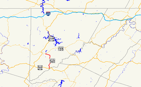
Maryland Route 560 highlighted in redRoute information Maintained by MDSHA Length: 9.32 mi[1] (15.00 km) Major junctions South end:  US 50 in Gorman
North end:  MD 135 in Mountain Lake Park
Location Counties: Garrett Highway system Maryland highway system
Interstate • US • State • Minor • Former • Turnpikes←  MD 559
MD 561  →
→Maryland Route 560 (MD 560) is a state highway in the U.S. state of Maryland. Known for most of its length as Gorman Road, the state highway runs 9.32 miles (15.00 km) from U.S. Route 50 (US 50) in Gorman north to MD 135 in Mountain Lake Park. MD 560 serves as the main street of Loch Lynn Heights. The state highway also provides a connection through southeastern Garrett County between US 50 on the east side of Backbone Mountain and the Oakland area. MD 560 was constructed from both ends beginning in the early 1930s. After the northern segment was extended over Backbone Mountain in the late 1930s, it was not until 1949 that the gap in MD 560 was filled.
Contents
Route description
MD 560 begins at an intersection with US 50 (George Washington Highway) just west of the Potomac River and CSX's Thomas Subdivision in Gorman. After passing through the village and crossing Nydegger Run, the state highway heads north as two-lane Gorman Road through farmland. MD 560 crosses Glade Run and meets White Church Steyer Road next to the hamlet of Kearney before turning northwest and crossing Backbone Mountain at Kelso Gap. After descending the mountain, the state highway turns west toward Loch Lynn Heights. The name of MD 560 changes to Lothian Street upon entering the town limits. At Argyle Street, MD 560 veers west onto Third Street then turns north onto Paull Street. MD 560 leaves Loch Lynn Heights by crossing CSX's Mountain Subdivision at grade and enters Mountain Lake Park, where the state highway immediately reaches its northern terminus at MD 135 (Maryland Highway).[1][2]
History
MD 560 was constructed beginning in 1930 from both the Loch Lynn Heights and Gorman ends.[3] By 1933, the state highway was paved from US 50 north to Le Moyne King Road, and from MD 41 (now MD 135) south to Bethlehem Road just north of Backbone Mountain.[4]/ The northern section was extended over Backbone Mountain to White Church Steyer Road at Kearney by 1939.[5] MD 560 was a two-part route until the gap between Le Moyne King Road and Kearney was filled in 1949.[6][7]
Junction list
The entire route is in Garrett County.
Location Mile
[1]Destinations Notes Gorman 0.00 US 50 (George Washington Highway) – Red House, Gormania, WVSouthern terminus Kearney 4.18 White Church Steyer Road east Former MD 639 Loch Lynn Heights 9.14 Third Avenue west MD 560 turns north onto Paull Street Mountain Lake Park 9.32 MD 135 (Maryland Highway) – Oakland, WesternportNorthern terminus 1.000 mi = 1.609 km; 1.000 km = 0.621 mi References
- ^ a b c "Highway Location Reference: Garrett County" (PDF). Maryland State Highway Administration. 2009. http://www.marylandroads.com/Location/2009_GARRETT.pdf. Retrieved 2010-10-27.
- ^ Google, Inc. Google Maps – Maryland Route 560 (Map). Cartography by Google, Inc. http://maps.google.com/maps?f=d&source=s_d&saddr=MD-560+N%2FGorman+Rd&daddr=Paul+St&geocode=FWqRVwIdFEJF-w%3BFdIiWQIduNpE-w&hl=en&mra=ls&sll=39.392992,-79.367938&sspn=0.015223,0.038581&ie=UTF8&t=h&z=12. Retrieved 2010-10-27.
- ^ Report of the State Roads Commission of Maryland. 1927-1930. Baltimore: Maryland State Roads Commission. 1930-10-01. p. 213. http://www.archive.org/details/reportofstateroa1927mary. Retrieved 2010-10-27.
- ^ Maryland Geological Survey. Map of Maryland Showing State Road System: State Aid Roads and Improved County Road Connections (Map) (1933 ed.).
- ^ Maryland State Roads Commission. General Highway Map: State of Maryland (Map) (1939 ed.).
- ^ Report of the State Roads Commission of Maryland. 1947-1948. Baltimore: Maryland State Roads Commission. 1949-02-15. p. 133. http://www.archive.org/details/reportofstateroa1947mary. Retrieved 2010-10-27.
- ^ Maryland State Roads Commission. Maryland: Official Highway Map (Map) (1949 ed.).
External links
Roads in Garrett County, Maryland State highways 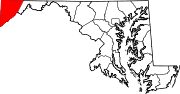
U.S. Highways Interstate Highways Categories:- State highways in Maryland
- Roads in Garrett County, Maryland


Wikimedia Foundation. 2010.