- Geography of Guinea-Bissau
-
 Map Of Guinea Bissau
 Satellite image of Guinea-Bissau
 Topography of Guinea-Bissau
 Typical scenery in Guinea-Bissau
This article describes the geography of Guinea-Bissau.
Contents
Climate
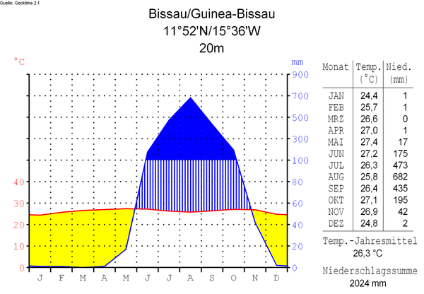
The climate in Guinea-Bissau is tropical. This means it is generally hot and humid. It has a monsoonal-type rainy season (June to November) with southwesterly winds and a dry season (December to May) with northeasterly harmattan winds.[1]
Guinea-Bissau is warm all year around and there is little temperature fluctuation; it averages 26.3 °C (79.3 °F). The average rainfall for Bissau is 2,024 millimetres (79.7 in) although this is almost entirely accounted for during the rainy season which falls between June and September/October. From December through April, the country experiences drought.
Terrain and ecology
The terrain of Guinea-Bissau is mostly low coastal plain with swamps of Guinean mangroves rising to Guinean forest-savanna mosaic in the east.[1]
The lowest point on Guinea-Bissau is at sea level at the Atlantic Ocean.[1] The highest point on Guinea-Bissau is 300 metres above sea level at an unnamed location in the northeast corner of the country.[1]
Natural resources found in Guinea-Bissau include fish, timber, phosphates, bauxite, clay, granite, limestone and unexploited deposits of petroleum.[1] 8.31% of the land is arable and 250 square kilometres is irrigated.[1] Natural hazards include a hot, dry, dusty harmattan haze that may reduce visibility during the dry season and brush fires.[1] Severe environmental issues include deforestation; soil erosion; overgrazing and overfishing.[1]
Near the Senegal border there have been historic sightings of the Painted Hunting Dog, Lycaon pictus, but that endangered canid may now be extirpated in that locale.[2]
Bissagos Islands
Main article: Bissagos IslandsInformation from the CIA World Factbook
- Location
- Western Africa, bordering the North Atlantic Ocean, between Guinea and Senegal
- Geographic coordinates
- 12°00′N 15°00′W / 12°N 15°W
- Map references
- Area
-
- Total: 36,120 km²
- Land: 28,000 km²
- Water: 8,120 km²
- Area—comparative
- Slightly less than three times the size of Connecticut
- Land boundaries
-
- Total: 724 km
- Border countries: Guinea 386 km, Senegal 338 km
- Coastline
- 350 km
- Maritime claims
-
- Exclusive economic zone: 200 nmi (370.4 km; 230.2 mi)
- Territorial sea: 12 nmi (22.2 km; 13.8 mi)
- Terrain
- Mostly low coastal plain rising to savanna in east
- Elevation extremes
-
- Lowest point: Atlantic Ocean 0 m
- Highest point: Unnamed location in the northeast corner of the country 300 m
- Natural resources
- Fish, timber, phosphates, bauxite, unexploited deposits of petroleum
- Land use
-
- Arable land: 11%
- Permanent crops: 1%
- Permanent pastures: 38%
- Forests and woodland: 38%
- Other: 12% (1993 est.)
- Irrigated land
- 17 km² (1993 est.)
- Natural hazards
- Hot, dry, dusty harmattan haze may reduce visibility during dry season; brush fires
- Environment—current issues
- Deforestation; soil erosion; overgrazing; overfishing
- Environment—international agreements
-
- Party to: Biodiversity, Climate Change, Desertification, Endangered Species, Law of the Sea, Wetlands
- Signed, but not ratified: None of the selected agreements [1]
Extreme points
This is a list of the extreme points of Guinea-Bissau, the points that are farther north, south, east or west than any other location.
- Northern-most point – the northern section of the border with Senegal*
- Eastern-most point – unnamed location on the border with Guinea immediately south-west of the Guinean village of Sofan, Gabú Region
- Southern-most point – unnamed headland on Ilha Cataque, Tombali Region
- Western-most point - Cap Roxo at the point where the border with Senegal enters the Atlantic Ocean, Cacheu Region
- *Note: Guinea-Bissau does not have a northern-most point, the border here being formed by a straight horizontal line
See also
Line notes
References
- C. Michael Hogan. 2009. Painted Hunting Dog: Lycaon pictus, GlobalTwitcher.com, ed. N. Stromberg
- U.S. Central Intelligence Agency. [2]
Guinea-Bissau Politics President · Prime Minister · Parliament · Elections · Political parties · Military · Coat of arms · Human rights · Foreign relations
History Regional history · Kaabu · African slave trade · Portuguese Guinea · War of Independence · PAIGC · Civil War · UNOGBIS · 2010 military unrestGeography Economy Society Sovereign
states- Algeria
- Angola
- Benin
- Botswana
- Burkina Faso
- Burundi
- Cameroon
- Cape Verde
- Central African Republic
- Chad
- Comoros
- Democratic Republic of the Congo
- Republic of the Congo
- Côte d'Ivoire (Ivory Coast)
- Djibouti
- Egypt
- Equatorial Guinea
- Eritrea
- Ethiopia
- Gabon
- The Gambia
- Ghana
- Guinea
- Guinea-Bissau
- Kenya
- Lesotho
- Liberia
- Libya
- Madagascar
- Malawi
- Mali
- Mauritania
- Mauritius
- Morocco
- Mozambique
- Namibia
- Niger
- Nigeria
- Rwanda
- São Tomé and Príncipe
- Senegal
- Seychelles
- Sierra Leone
- Somalia
- South Africa
- South Sudan
- Sudan
- Swaziland
- Tanzania
- Togo
- Tunisia
- Uganda
- Zambia
- Zimbabwe
States with limited
recognition- Sahrawi Arab Democratic Republic
- Somaliland
Dependencies and
other territories- Canary Islands / Ceuta / Melilla / Plazas de soberanía (Spain)
- Madeira (Portugal)
- Mayotte / Réunion (France)
- Saint Helena / Ascension Island / Tristan da Cunha (United Kingdom)
- Western Sahara
Climate of Africa Sovereign
states- Algeria
- Angola
- Benin
- Botswana
- Burkina Faso
- Burundi
- Cameroon
- Cape Verde
- Central African Republic
- Chad
- Comoros
- Democratic Republic of the Congo
- Republic of the Congo
- Côte d'Ivoire (Ivory Coast)
- Djibouti
- Egypt
- Equatorial Guinea
- Eritrea
- Ethiopia
- Gabon
- The Gambia
- Ghana
- Guinea
- Guinea-Bissau
- Kenya
- Lesotho
- Liberia
- Libya
- Madagascar
- Malawi
- Mali
- Mauritania
- Mauritius
- Morocco
- Mozambique
- Namibia
- Niger
- Nigeria
- Rwanda
- São Tomé and Príncipe
- Senegal
- Seychelles
- Sierra Leone
- Somalia
- South Africa
- South Sudan
- Sudan
- Swaziland
- Tanzania
- Togo
- Tunisia
- Uganda
- Zambia
- Zimbabwe
States with limited
recognition- Sahrawi Arab Democratic Republic
- Somaliland
Dependencies and
other territories- Canary Islands / Ceuta / Melilla / Plazas de soberanía (Spain)
- Madeira (Portugal)
- Mayotte / Réunion (France)
- Saint Helena / Ascension Island / Tristan da Cunha (United Kingdom)
- Western Sahara
Categories:- Islands of Guinea-Bissau
- Geography of Guinea-Bissau


Wikimedia Foundation. 2010.