- Coyote Point Park
-
Coyote Point Park 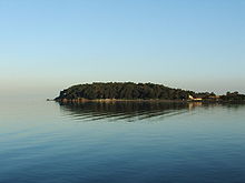
Coyote PointType Parkland, woodland, museum & zoo Location San Mateo County, California, USA Coordinates 37°35′22″N 122°19′34″W / 37.5893796°N 122.3260810°WCoordinates: 37°35′22″N 122°19′34″W / 37.5893796°N 122.3260810°W Area 670 acres (270 ha)[1] Created 1962 Operated by San Mateo County, California Open All year Coyote Point Park is a 670-acre (270 ha) park in San Mateo County, California, United States. Located on San Francisco Bay, it is south of San Francisco International Airport on the border of Burlingame and San Mateo.
The distinctive point, covered by a grove of eucalyptus trees, can be seen from airplanes approaching San Francisco International Airport and is a good point for airplane watching.[1][2]
Contents
History
Coyote Point was originally an island in San Francisco Bay with a marsh connecting it to the mainland. Because it has no fresh water, it is doubtful that Native Americans lived here, but shell mounds on the point indicate that it was at least occasionally used, possibly for special ceremonies or feasts.[3]
Coyote Point was part of the Presidio and Mission lands until it passed to Mexico. The Governor of Mexico then granted the land to Coyetano Arenas, to which the name can probably be traced. The Arenas family sold it to the firm of Mellus and Howard, and Howard purchased it from the firm in 1850. The land remained in the Howard family until it was sold to the county and the federal government in 1942.[3]
In the late 19th century, the Howard family built a pier at Coyote Point for lumber loading. They also reclaimed the marsh between the island and the mainland (now a golf course) to create dairy pasture. They built a bathhouse and pool on the beach in 1880, and had Eucalyptus, Cypress and Pine trees planted on the knoll.[3]
In 1922, a group of promoters created the "Pacific City Amusement Park" on about 90 acres (36 ha) of land along the beach leased from the Howard family. The park included a boardwalk, children's playground, scenic railway, merry-go-round, Ferris wheel, dancing pavilion and several food concessions. Although it was reputed to have had one million visitors in the first season, a fire during the second season destroyed about one quarter of the development, and it never opened for a third season. The reasons give for the closure were strong afternoon winds and sewage contamination in the bay.[3]
In 1942, the federal government purchased the original Coyote Point for a Merchant Marine Cadet School. In 1946, the buildings were purchased by the College of San Mateo, and this became the college campus until the land was acquired by San Mateo County in 1962.[3]
Facilities
The park contains many trails for walking and bicycling, and includes sections of the San Francisco Bay Trail. In addition, there are many small picnic areas throughout the park, eight larger picnic areas available by registration, the Captains House Conference Facility, the Coyote Point Pistol and Rifle Range, the Coyote Point Museum for Environmental Education, and the Coyote Point Marina.[4]
CuriOdyssey
Main article: CuriOdysseyCuriOdyssey, formerly the Coyote Point Museum for Environmental Education is a hands-on science museum and native animal zoo located in the park at 1651 Coyote Point Drive in San Mateo, California, United States.
- The Main Concourse Science Exhibits offer a variety of hands-on science exhibits that allow children and families to experience natural phenomena up-close.
- The Wildlife Habitats consist of 25 naturalistic habitats that house over 50 non-releasable animals native to California, including a bobcat, river otter, snakes, golden eagles, Channel Island fox, banana slugs, turtles, owls, snowy egret, tarantula, Western toads, herons, turkey vultures, raccoons, badger, porcupine, coyote and others.
- The Aviary is a 4,000-square-foot (370 m2) walk-through facility that houses over a dozen non-releasable, native California birds.[5]
- The Invertebrate Corner houses a live beehive and a variety of native invertebrates including a California blond tarantula, black widow spider, dermestid beetles and others.
- The Gardens cover about 1.3 acres (0.53 ha) and consist of a variety of plants, some native. They include a hummingbird garden, butterfly habitat, and the Nature's Marketplace Garden which features native plants used by Native Californians.
Notes
- ^ a b "Coyote Point Park". baytrail.abag.ca.gov. Ronald Horii. http://baytrail.abag.ca.gov/vtour/map2/access/CoyotePt/CoyotePt.htm. Retrieved 12 June 2011.
- ^ "Coyote Point Recreation Area". co.sanmateo.ca.us. San Mateo County. http://www.co.sanmateo.ca.us/portal/site/parks/menuitem.f13bead76123ee4482439054d17332a0/?vgnextoid=563bc8909231e110VgnVCM1000001d37230aRCRD&cpsextcurrchannel. Retrieved 16 April 2010.
- ^ a b c d e "Coyote Point Recreation Area:History". co.sanmateo.ca.us. San Mateo County. http://www.co.sanmateo.ca.us/portal/site/parks/menuitem.f13bead76123ee4482439054d17332a0/?vgnextoid=563bc8909231e110VgnVCM1000001d37230aRCRD&cpsextcurrchannel=1#History. Retrieved 16 April 2010.
- ^ "Coyote Point Recreation Area:Facilities". co.sanmateo.ca.us. San Mateo County. http://www.co.sanmateo.ca.us/portal/site/parks/menuitem.f13bead76123ee4482439054d17332a0/?vgnextoid=563bc8909231e110VgnVCM1000001d37230aRCRD&cpsextcurrchannel=1#Facilities. Retrieved 16 April 2010.
- ^ "Our Animals". coyoteptmuseum.org. Coyote Point Museum. http://www.coyoteptmuseum.org/exhibits-and-animals/our-animals. Retrieved 11 April 2010.
External links
Categories:- San Mateo, California
- Burlingame, California
- Parks in San Mateo County, California
- San Francisco Bay
- Regional parks in California

Wikimedia Foundation. 2010.