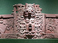
Chaa Creek

Chaa Creek

Chaa Creek is a tributary of the Macal River in the Cayo District in western Belize. One of the official gauging stations of the Macal is located near the confluence with Chaa Creek.[1] There are also Maya ruins that remain largely unexcavated in the Chaa Creek catchment basin; certain early research was conducted on the archaeology at Chaa Creek in 1997 by Harvard University.[2] Significant pottery finds and other artifacts have been recovered at the Chaa Creek site, which is posited to be a satellite site of Xunantunich.[2][3] The Chaa Creek Nature Reserve is a noted area in western Belize for birding and other natural history study. (Milwaukee, 2000) The underlying geology of this watershed can be characterised as limestone associations of foothills of the Maya Mountains.[4]

See also

References


Wikimedia Foundation. 2010.

Игры ⚽ Поможем сделать НИР

Look at other dictionaries:

  • Arroyo Chaa — (también Chaa Creek en Belice) es una corriente de agua afluente del Río Macal, en el Distrito de Cayo en el oeste de Belice. Una de las estaciones hidrológicas de control del río Macal se encuentra ubicada muy cerca de la confluencia del arroyo… …   Wikipedia Español

  • Caracol — This article is about the Maya archaeological site in Belize. For the military manoeuver, see Caracole. For other uses, see El Caracol (disambiguation). Coordinates: 16°45′50.14″N 89°7′3.33″W /  …   Wikipedia

  • Cayo District — is a district in the west of the nation of Belize. The District capital is the town of San Ignacio. Geography The Cayo District is the largest district in Belize. Within the Cayo District are the national capital of Belmopan, the district capital …   Wikipedia

  • Cahal Pech — is a Maya site located near the Town of San Ignacio in the Cayo District of Belize. The site was a palacio home for an elite Maya family, and though most major construction dates to the Classic period, evidence of continuous habitation has been… …   Wikipedia

  • Belize River — The Belize River Origin Confluence Mopan and Macal rivers …   Wikipedia

  • Macal River — Infobox River river name = Macal caption = Macal River in Belize origin = Maya Mountains mouth = Caribbean Sea basin countries = Belize length = 320 kilometers elevation = 953 meters (Cooma Cairn) discharge = watershed = 1492 km²The Macal River… …   Wikipedia

  • Актун-Туничиль-Мукналь — «Хрустальная д …   Википедия

  • Montes Maya — País(es)  Belice …   Wikipedia Español

  • Xunantunich — (shoo NAHN too nich) is a Maya archaeological site in western Belize, about 80 miles (130 km) west of Belize City (Latitude : 17.083 , Longitude : 89.133), in the Cayo District. Xunantunich is located atop a ridge above the Mopan River, within… …   Wikipedia

  • Tipu — This article is about a Mayan archaeological site; for the sultan see Tippu Sultan. Tipu is a Mayan archaeological site [ [http://ambergriscaye.com/earlyhistory/8.html Early History of Belize] ] in the Maya Mountains near the Belize Guatamala… …   Wikipedia

Share the article and excerpts

Direct link
Do a right-click on the link above
and select “Copy Link”