- Karratha, Western Australia
-
Karratha
Western Australia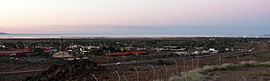
Karratha at dusk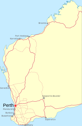
 Karratha
Population: 11,728(2006)[1] Established: 1960s Postcode: 6714 Coordinates: 20°44′11″S 116°50′47″E / 20.73649°S 116.84638°ECoordinates: 20°44′11″S 116°50′47″E / 20.73649°S 116.84638°E Time zone: AWST (UTC+8) Location: 1575 km (979 mi) from Perth LGA: Shire of Roebourne State District: North West Federal Division: Durack Mean max temp Mean min temp Annual rainfall 32.3 °C
90 °F20.7 °C
69 °F271.7 mm
10.7 inKarratha is a town adjoining the port of Dampier in the Pilbara region of Western Australia which was developed from the 1960s to accommodate the processing and exportation workforce of the Hamersley Iron mining company and, in the 1980s, the petroleum and liquefied natural gas operations of the North West Shelf Venture. The town's name comes from the cattle station from which land was reclaimed for the development. Karratha in the local Aboriginal language means 'God's country' or 'Sacred Earth' .[2] The town is the seat of government of the Shire of Roebourne.
Contents
Geography
Karratha is located approximately 1,535 kilometres (954 mi) north of Perth and 850 kilometres (528 mi) south of Broome on the North West Coastal Highway.
Suburbs
Karratha is composed of 9 main suburbs: Karratha Town Centre, Bulgarra, Pegs Creek, Millars Well, Nickol, Nickol West, Baynton, Baynton West, Tambrey and one industrial area, known as both the LIA (Light Industrial Area) and KIE (Karratha Industrial Estate). Karratha's housing development continues, with new villages and suburbs being built.. Nickol has been expanded, with Nickol West completed in 2008. Baynton West is also being developed, and the expectation is that a 75% of the 523 lots will be built and occupied by early 2012.
Economy
Karratha's economic base includes the iron ore operations of the Rio Tinto Group, sea-salt mining, ammonia export operations, North West Shelf Natural Gas Project, Australia's largest natural resource development and the newest Natural Gas Project called Pluto LNG which is situated adjacent the existing North West Shelf LNG facility. Karratha came into being in the late 1960s due to the tremendous growth of the iron-ore industry and the need for a new regional centre caused by a shortage of land in Dampier. Karratha only has 4 major food stores such as KFC, Mc Donalds, Chicken Treat and Subway. Also grocery stores like Coles and Woolworths. There is also a K-Mart.
Karratha has the largest shopping centre in the Pilbara, Centro Karratha, which has major food and grocery retailers and department store chains.[3] It was opened in 1986 as Karratha City and expanded in 2005. The centre also serves the neighbouring towns of Dampier, Wickham and Roebourne. There is also a smaller centre, Karratha Village, which has health services including pharmacy, medical and dental practices. There is only one hospital in Karratha.
A new shopping centre has been proposed for the Tambrey area. It is currently under review by the Shire of Roebourne and looks set to begin construction late 2011.[dated info]
Climate
Climate data for Karratha Month Jan Feb Mar Apr May Jun Jul Aug Sep Oct Nov Dec Year Average high °C (°F) 36.1
(97.0)35.4
(95.7)36.0
(96.8)34.2
(93.6)30.1
(86.2)26.4
(79.5)26.2
(79.2)28.0
(82.4)30.6
(87.1)33.8
(92.8)34.9
(94.8)35.8
(96.4)32.3 Average low °C (°F) 26.8
(80.2)26.7
(80.1)25.7
(78.3)22.6
(72.7)18.2
(64.8)14.9
(58.8)13.6
(56.5)14.2
(57.6)17.0
(62.6)20.5
(68.9)22.9
(73.2)25.4
(77.7)20.7 Precipitation mm (inches) 40.7
(1.602)75.4
(2.969)53.9
(2.122)18.8
(0.74)22.2
(0.874)30.3
(1.193)15.0
(0.591)5.1
(0.201)1.0
(0.039)0.4
(0.016)0.6
(0.024)12.2
(0.48)278.5
(10.965)Source: [4] Facilities
A range of hotel, motel, B&B and caravan/RV accommodation is available for visitors. However, as the town is booming, accommodation is often hard to come by.
The town has restaurants, a tavern, two hotels and two night clubs. It also has a large shopping centre an 8 story apartment and shopping complex named Pelago.
Education is provided through four public primary schools and one private primary school, one public and one private high school, a TAFE centre with remote university facilities, and a library.
As well as its professional medical services, the district is served by the Nickol Bay Hospital which provides a comprehensive array of services, facilities and training.[5]
Karratha Airport with frequent services to and from Perth, is the second busiest in Western Australia; it has three passenger airlines servicing the town with regular schedules: Qantas, Skywest Airlines and Virgin Australia. Qantas also flies twice-weekly services between Brisbane and Karratha—the first direct link between the Pilbara region and Australia's east coast.[6] The airport also serves as the hub of the Pilbara's light-aircraft and helicopter services,[7] enabling contractors to access destinations offshore and in other parts of the region.
Annual Festivals & Events
FeNaClNG
Each year in August Pilbara Iron, Dampier Salt, Woodside Petroleum Limited (WEL), and other smaller companies sponsor one of the largest festivals in the North West, over two days. The name FeNaClNG Festival is derived from Fe (iron), NaCl (salt) and NG (natural gas).Christmas Lights
Beginning in December 2009, the town of Karratha is also host to one of Australia's largest Christmas lights competitions, with a total of $6,000 cash prizes (First prize of up to $3,000). The competition is a partnership between the local newspaper Pilbara Echo [1], Woodside Energy, and Horizon Power.Media
Radio
Radio services available in Karratha:
- Karratha FM 93.7 - "Today`s Hot Country" [8] (country music format)
- ABC North West WA (6KP: 702 AM) - (Part of the ABC Local Radio Network).
- ABC News Radio (6PNN: 104.1 FM)
- ABC Radio National (6ABCRN: 100.9 FM) - Speciality talk and music.
- TAB Racing Radio - FM 101.7 [9]
- Triple J (6JJJ: 103.3 FM) - Alternative music
- WAFM (106.5) - Top 40 Music
- The Spirit Network - Radio 6KA (1260 AM) - Classic Hits / Adult Contemporary Music format aimed at 35 years + audience.
Television
Television services available:
- The Australian Broadcasting Corporation (ABC) - ABC1, ABC2/4 (Extension of ABC TV/Young children), ABC3 (Tween/Teen), ABC News 24 (digital channels)
- The Special Broadcasting Service (SBS) - SBS One, SBS Two, SBS HD (digital channels)
- WIN Television, a dual affiliate of both the Nine Network and Network Ten.
- GWN7, an affiliate of the Seven Network.
The programming schedule is mainly the same as the Seven, Nine and Ten stations in Perth with variations for News bulletins, sport telecasts such as the Australian Football League and National Rugby League, children's and lifestyle programs and infomercials or paid programming.
Both GWN7 and WIN provide local news services that screen Monday to Friday. GWN7 News screens at 5.30pm before Seven News Perth. WIN News screens at 5.30pm before Nine News Perth.
New Digital television services from GWN7 and WIN are now broadcasting in Karratha. A new digital-only channel branded Ten West commenced transmission on Thursday 10 June 2010, it is a sole Network Ten affiliated channel.
Newspapers
The current local classifieds for Karratha and the wider Pilbara region is the weekly publication The Pilbara Echo. [10] The Local Newspaper is "The Pilbara News" (Owned by The West Australian) Newspapers from Perth including The West Australian and The Sunday Times are also available, as well as National Newspaers such as The Australian and The Australian Financial Review.
References
- ^ Australian Bureau of Statistics (25 October 2007). "Karratha (Urban Centre/Locality)". 2006 Census QuickStats. http://www.censusdata.abs.gov.au/ABSNavigation/prenav/LocationSearch?collection=Census&period=2006&areacode=UCL512800&producttype=QuickStats&breadcrumb=PL&action=401. Retrieved 2008-10-02.
- ^ Western Australian Land Information Authority. "History of country town names". http://www.landgate.wa.gov.au/corporate.nsf/web/History+of+country+town+names. Retrieved 2007-06-08.
- ^ "Centro Karratha Overview". Centro Properties Group. http://www.centro.com.au/Shopping+Centres/Shopping+Centre+Directory/Centro+Karratha/Centro+Karratha+Overview.htm. Retrieved 2008-12-23.
- ^ "BOM". August 2011. http://www.bom.gov.au/climate/averages/tables/cw_004083.shtml.
- ^ WA Consumer Health Services Directory: Nickol Bay Hospital Dept of Health, WA Government
- ^ Qantas spreads its wings to KarrathaThe Australian, 5 October 2007
- ^ Bower S Bristow delivers WA Business News, 13 November 2002
- ^ URL link to Karratha FM 93.7 - Today's Hot Country" http://local.fm/karratha/announcers.html
- ^ W.A. TAB Racing Radio list of frequncies page http://www.ozbet.com.au/UI/ContentUI/AllContent.aspx?contentCode=Racing Radio Information&contentMenuType=About Content Menu
- ^ The Pilbara Echo website http://pilbaraecho.com.au/echo/
External links
Towns in the Pilbara region of Western Australia Cossack · Dampier · Goldsworthy · Jigalong · Karratha · Marble Bar · Newman · Nullagine · Onslow · Pannawonica · Paraburdoo · Point Samson · Port Hedland · Roebourne · Shay Gap · South Hedland · Telfer · Tom Price · Whim Creek · Wickham · Wittenoom
Cities of Western Australia Capital city Metropolitan cities Regional cities Large towns Categories:- Australian Aboriginal placenames
- Port cities in Australia
- Towns in Western Australia
- Mining towns in Western Australia
- Pilbara
- Coastal towns in Western Australia


Wikimedia Foundation. 2010.